Final snow total, 6.3" here, 15"+ on Long Island


nan said:
spontaneous said:
Crap, I have a doctor's appointment tomorrow at 11. And he's usually booked for weeks in advance and I know my tsh level off and my synthroid needs to be adjusted. Ugh.
Did you get your blood work done? If so, he can look at it and adjust without your coming in the office. Might not be until Friday though.
I'm hoping he can. He is great in person, but his office staff are sometimes a little difficult to get messages through.


Jitney is running. Just took the Wyoming one. And my 629 train was on time.


In the words of the NWS: "THIS IS A DANGEROUS STORM...PLEASE DO NOT TRAVEL IF AT ALL
POSSIBLE."
With temps now below freezing, precipitation is all snow. Changeover happened between 5:00 and 6:00 this morning, there might be a bit of ice glaze but no significant accumulation.
Forecast:
Snow, heavy at times, throughout the day. The storm has slowed a bit; heaviest snow midmorning to late afternoon. Both rush hours will be affected.
Total snowfall still 10 - 12" but I would not be surprised if we come in towards the higher end. Snowfall rates of 1-2"/hour at the height of the storm will challenge road crews, possible rates of 2-3" in heaviest banding with overwhelm them, at least in the short term. In Maplewood, crews are already out.
Wind 20 - 25 mph with gust to 35 mph at the height of the storm. There is a possibility of thundersnow, lightening strikes were reported early this morning as the front passed through Virginia and Maryland.
From the NWS:
"URGENT - WINTER WEATHER MESSAGE...CORRECTEDNational Weather Service New York NY
534 AM EST Thu Feb 9 2017
...Powerful Winter Storm Today...
...WINTER STORM WARNING REMAINS IN EFFECT UNTIL 6 PM EST THIS
EVENING...
* Snow Accumulations...10 to 14 inches.
* Locations...New York City, Southern Connecticut, the Lower
Hudson Valley and Northeastern New Jersey.
* Hazard type...Heavy snow.
* Timing...Today.
* Impacts...Hazardous/dangerous travel due to snow covered roads
and poor visibilities. Blowing and drifting snow is likely.
Local power outages with downed trees and power lines possible.
* Winds...North 15 to 25 mph with gusts 30 to 35 mph.
* Visibilities...one quarter mile or less at times.
* Temperatures...Falling into the 20s.
PRECAUTIONARY/PREPAREDNESS ACTIONS...
A Winter Storm Warning for Heavy Snow means severe winter weather
conditions are expected or occurring. Significant amounts of snow
are forecast that will make travel dangerous. Only travel in an
emergency. If you must travel...keep an extra flashlight...food...
and water in your vehicle in case of an emergency."
If you can possible stay home today, stay home.
If you can possibly stay off the roads today, stay home.

I agree, I stayed in the city last night, close to work, got to the office at 5:30 and the snow, big flakes, already blowing sideways, good day to stay in with some hot chocolate.
Thundersnow reported in the city and Long Island, including at NWS office in Upton, with at least one lightening strike on Long Island. Probably not going to happen here at this point.
The storm is moving through very quickly. While there are still a few serious bands to come through, this is the worst of it unless it slows and backs on us. We will know if that is happening fairly soon.
At 7:00am we had 1.8"
I suppose I could go out and measure again. that would give me an excuse to have another cup of coffee, so it might be worth it....
So... we don't have to worry about 12" this time, which is quite a relief!
10:00 am reading:
5.1" snow
0.56" water
Ratio = 9:1 this is fairly heavy snow. Will clog the snowblower a bit.
At this rate we will come in on the lower end of the forecast snowfall.
case said:
So... we don't have to worry about 12" this time, which is quite a relief!
I would say 8-10" based on current observation.

Just went out for round one. Even with blower it is was hard. So second round this afternoon should not be bad.


Just finished first pass, we have two snowblowers, large and small, so while not easy, wasn't as bad as I expected. I also have a 25 year old today, so that helped a lot. 
I did round one (shoveled deck, cleared driveway and sidewalks with blower) starting at 10am. Had to run the blower in lowest and next-to-lowest gear. Slow, but otherwise not terrible.
Looks like one last heavy band on the radar. Should arrive shortly.

Tapering off dramatically in WO. Just light snow now, plus the wind-blown stuff.

max_weisenfeld said:
Looks like one last heavy band on the radar. Should arrive shortly.
Are we still waiting on another heavy band of snow?
mammabear said:
max_weisenfeld said:
Looks like one last heavy band on the radar. Should arrive shortly.
Are we still waiting on another heavy band of snow?
No, it passed through quickly. We are into the tapering off period for snowfall. For the rest of the afternoon, blowing and drifting are the main concerns.

... Along with snowplows pushing a new pile of sludge & frozen ice blocks onto the driveway apron you just finished clearing 5 minutes ago....

sprout said:
... Along with snowplows pushing a new pile of sludge & frozen ice blocks onto the driveway apron you just finished clearing 5 minutes ago....
Always!
Would rather have had 10 inches of fluffy snow then 6.1 of heavy wet snow.

jim4284 said:
Would rather have had 10 inches of fluffy snow then 6.1 of heavy wet snow.
Agreed! I think it was probably about the same amount of moisture.
sac said:
jim4284 said:
Would rather have had 10 inches of fluffy snow then 6.1 of heavy wet snow.
Agreed! I think it was probably about the same amount of moisture.
No, it wasn't.
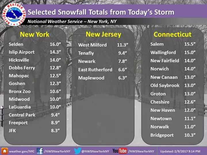
We got 0.71" of water in the storm, and NWK got 0.81" but NWK reported 8" of snow so there is that, but
Central Park: 1.16" water
Islip: 1.30"
New London, Conn: 1.7"
The storm stalled in the early afternoon, and a band set up west of us that never really hit us, while the heaviest band stalled on a line from central Long Island up through central Conn then moved out east and north. Central Mass got 15 - 17 while the Boston area got about a foot.
I suspect western areas had a longer period of rain/sleet at the beginning of the storm, and snow yield went up as the storm moved east.

I measured close to 10 inches of snow in Morristown in a part of my lawn that is sheltered from the wind.
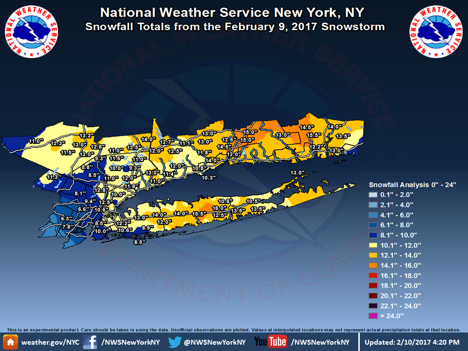
Map from the NWS:
"Here is a map showing snowfall totals from yesterday's storm. Amounts ranged from 6-8" in parts of northeast NJ to over a foot across much of Long Island and southern CT. Islip, NY set a new daily snowfall record with 14.3" of snow."
Here
is a map showing snowfall totals from yesterday's storm. Amounts ranged
from 6-8" in parts of northeast NJ to over a foot across much of Long
Island and southern CT. Islip, NY set a new daily snowfall record with
14.3" of snow.

Employment Wanted
Latest Jobs
Employment Wanted
-
Our amazing driving nanny is available for work.
Apr 28, 2024 at 8:05am
-
(No Fees) Hire A Baby Nurse Here for Your New Borns! (732)-737-7165
Apr 27, 2024 at 1:46am
-
(NO FEES) Hire A Fresh Energetic Nanny/ Housekeeper Here ! (732)-737-7165
Apr 27, 2024 at 1:46am
-
(NO Fees) Hire Housekeepers Here! ( 732)-737-7165
Apr 27, 2024 at 1:46am
-
(No Fees) Hire Home Health Aides Here! (732)-737-7165
Apr 27, 2024 at 1:46am
-
Summer Private Speech Therapist
Apr 26, 2024 at 9:12pm
-
Apr 26, 2024 at 1:58pm
-
(Classic Painting and Materials) Fair Prices. Spring and Summer Specials
Apr 25, 2024 at 5:14pm
Help Wanted
-
Part Time help for special needs young adult
Apr 27, 2024 at 4:43pm
-
Apr 25, 2024 at 6:15pm
Lessons/Instruction

Sponsored Business


Promote your business here - Businesses get highlighted throughout the site and you can add a deal.

Advertisement


NJ State offices closed Thursday, February 9, 2017
https://local.nixle.com/alert/5846178/?sub_id=2186554