Warning Ends, Snow Showers now, and again on Wednesday

If she can walk home from the Maplewood or South Orange train station, it will probably be fine. Trains handle snow pretty well - better than cars.
Otherwise, what meganlibrarian said above.


finnegan said:
If she can walk home from the Maplewood or South Orange train station, it will probably be fine. Trains handle snow pretty well - better than cars.
Otherwise, what meganlibrarian said above.
But in this scenario, she should go on in to New York Penn and then take NJT out, because otherwise she'll likely be having to walk from Newark Penn to Newark Broad.

The storm will hit in DC before it hits here and she might check to see if the presentation will be cancelled. Or, can she deliver the presentation via Skype or similar service? This is a blizzard and the winds are quite strong. There may be places along the route where the trains may be delayed. And in blizzards, power lines go down, sometimes across RR tracks. If she must go, a good bet is to get a hotel room for Monday night.

Sorry, of course, you're right. Missed the part about landing at Newark Penn. Go to the city, then catch the train to town.
But, of course, who knows what things will be like mid-day Tuesday... Still I would have more confidence in trains than cars in snow storms.
sac said:
finnegan said:
If she can walk home from the Maplewood or South Orange train station, it will probably be fine. Trains handle snow pretty well - better than cars.
Otherwise, what meganlibrarian said above.
But in this scenario, she should go on in to New York Penn and then take NJT out, because otherwise she'll likely be having to walk from Newark Penn to Newark Broad.


Trains will be impacted as they rely on overhead lines for power and staff (who has to drive to get to work to run the trains). I would not bet on the trains.
finnegan said:
Sorry, of course, you're right. Missed the part about landing at Newark Penn. Go to the city, then catch the train to town.
But, of course, who knows what things will be like mid-day Tuesday... Still I would have more confidence in trains than cars in snow storms.
sac said:
finnegan said:
If she can walk home from the Maplewood or South Orange train station, it will probably be fine. Trains handle snow pretty well - better than cars.
Otherwise, what meganlibrarian said above.
But in this scenario, she should go on in to New York Penn and then take NJT out, because otherwise she'll likely be having to walk from Newark Penn to Newark Broad.

Trains do stop running in severe weather. Heavy snow fall can block the tracks and suspend rail service, switches can be frozen, strong winds can topple trees across tracks, etc. Best to leave before the storm is scheduled to start. Blizzard conditions are now projected for our area on Tuesday.


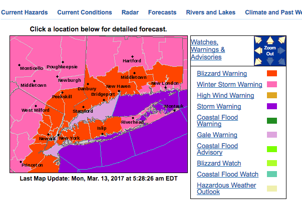
Over the last 24 hours, multiple models have indicated a shift in storm track to the north and west, along with an overall intensification of the storm. As a result, the blizzard warning has been moved west over our area.
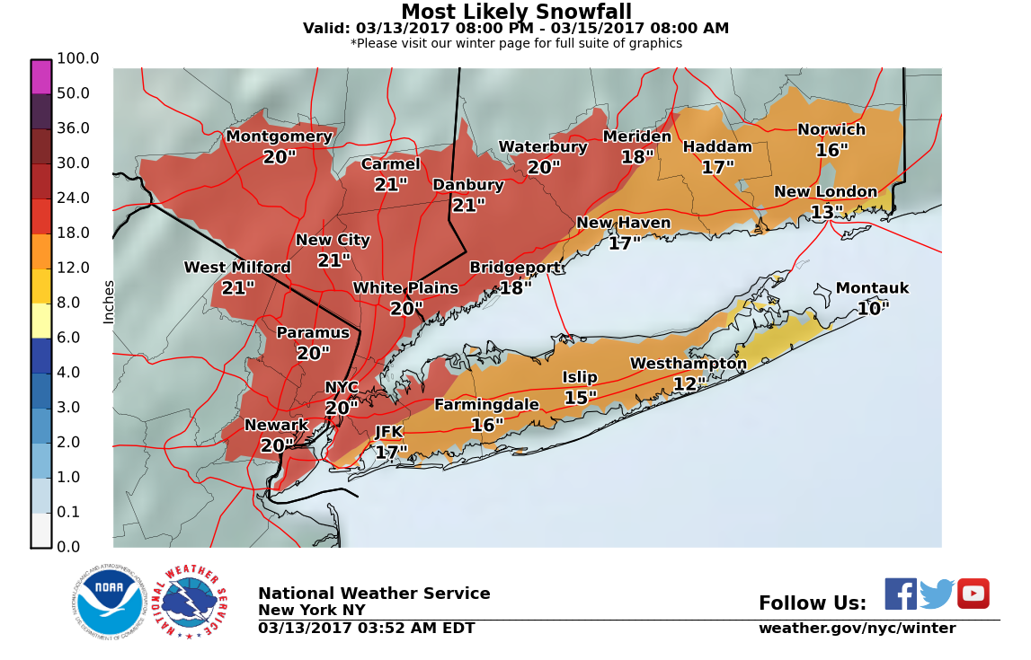
Forecast: Snow, heavy at times, starting after midnight tonight and continueing into tomorrow afternoon, then tapering off but some snow showers could persost into Wednesday. Accumulations of 18 - 24" likely. The core snowfall period, from early morning to early afternoon, could see several hours of 2+ inch/hour accumulation.
Wind: 25 - 30 mph with gusts to 40 mph means significant blowing and drifting likely, with whiteout conditions possible.
Travel: As I said yesterday, travel of any sort tomorrow morning will be inadvisable. With this upgrade, it is likely that travel tomorrow morning will be impossible.
From the NWS:
Blizzard Warning
URGENT - WINTER WEATHER MESSAGE
National Weather Service New York NY
418 AM EDT Mon Mar 13 2017
...Major Winter Storm Late Tonight into Tuesday Evening...
...BLIZZARD WARNING IN EFFECT FROM MIDNIGHT TONIGHT TO MIDNIGHT
EDT TUESDAY NIGHT...
The National Weather Service in Upton has issued a Blizzard
Warning, which is in effect from midnight tonight to midnight EDT
Tuesday night. The Winter Storm Warning is no longer in effect.
* Locations...Portions of northeastern New Jersey, Northern
Westchester, Northern Fairfield, and Northern New Haven
counties.
* Hazard Types...Heavy Snow and Blizzard Conditions.
* Snow Accumulations...18 to 24 inches.
* Snowfall Rates...2 to 4 inches per hour early Tuesday morning
into Tuesday afternoon.
* Timing...Late Tonight through Tuesday evening.
* Impacts...Dangerous travel due to whiteout conditions at times.
Several roads may become impassable. Power outages possible.
* Winds...Northeast 20 to 30 mph with gusts up to 40 mph on
Tuesday.
* Temperatures...In the mid 20s.
* Visibilities...One quarter mile or less at times.
PRECAUTIONARY/PREPAREDNESS ACTIONS...
A Blizzard Warning means severe winter weather conditions are
expected or occurring. Falling and blowing snow with strong winds
and poor visibilities are likely. This will lead to whiteout
conditions...making travel extremely dangerous. Do not travel. If
you must travel...have a winter survival kit with you. If you get
stranded...stay with your vehicle.

Mrs GoSlugs rescheduled and will be coming back this evening. Thank you all for your advice.

It sounds to me like walking even just from the train station will be potentially hazardous tomorrow. I think we're looking at some serious Jack London territory.
I'm glad Mrs GoSlugs rescheduled.

Thanks as always, Max, for making MOL the "go-to" place for reliable (and sometimes entertaining!) forecasting!

anyone know if this will be the light, fluffy, stuff, or wet and heavy ?

Here an excerpt of an alert I just got from my company's travel desk:
Airports
As of March 13, airlines had pre-emptively canceled more than 2,200 flights throughout the affected area. Extensive flight cancellations and lengthy delays are likely at airports throughout the northeast, including those serving Washington, DC (IAD, DCA), Baltimore (BWI), Philadelphia (PHL), New York (EWR, LGA, JFK), and Boston (BOS). Other airports where numerous cancellations will likely occur include those serving Albany (ALB), Bangor (BGR), Fredericton (YFC), Halifax (YHZ), Hartford (BDL), Providence (PVD), Moncton (YQM), Montreal (YUL), Portland (PWM), and Quebec City (YQB).
Flight operations will likely come to a standstill at airports experiencing blizzard conditions. Disruptions will likely persist into March 15 as airlines clear backlogs of stranded passengers. Many major carriers are offering flexible rebooking options for flights scheduled for March 14-15.
Roads
Heavy snowfall and blizzard conditions will cause significant ground transport, public transit, and commuting disruptions throughout the Mid-Atlantic and New England regions of the US, as well as in southeastern Canada. Hazardous road conditions are likely, especially in areas where strong winds complicate efforts to keep roads clear. Commercial trucking and traffic could be significantly impacted on area interstates, including on large portions of the I-64, I-66, I-70, I-76, I-80, I-81, I-83, I-84, I-86, I-87, I-88, I-90, I-91, I-93, and I-95 corridors, as well as along numerous other US and state highways. In Canada, similar disruptions are possible on the Trans-Canada Highway and provincial routes in Nova Scotia, New Brunswick, Quebec, and Prince Edward Island. Secondary and rural routes could become impassable.
High-profile vehicles may be subject to wind restrictions on some exposed bridges along the East Coast, and some bridges may temporarily close to traffic. The Washington DC, Philadelphia, New York City, and Boston metropolitan areas could enact snow emergencies/parking restrictions to assist in snow removal efforts. Mass transit in these cities, including bus services, could also experience delays and service changes, especially on March 14.
Rail
Amtrak Acela Express and Northeast Regional services may be significantly delayed or canceled during the storm. Metro, subway, and light rail services could operate on modified schedules in the Baltimore-Washington, DC; Philadelphia; New York City; and Boston metropolitan areas on March 14. Freight disruptions are possible along Norfolk Southern and CSX rail lines through the affected area.
Maritime
Strong winds and storm surge could cause some maritime disruptions at ports along the Atlantic coastline; however, disruptions to cargo-handling operations will likely be minor. Ferry services in the New York City and Boston metropolitan areas could be suspended while the system transits the region.

lazydog said:
anyone know if this will be the light, fluffy, stuff, or wet and heavy ?
Dear lord I hope it's just fluffy ;(
That may not be enough.
How much syrup?
drummerboy said:
I don't care what it is. I'm not leaving the house til it melts. I've got french toast supplies for a week.
dano said:
lazydog said:
anyone know if this will be the light, fluffy, stuff, or wet and heavy ?
Dear lord I hope it's just fluffy ;(
syrup? Yikes! Have to check.
mrincredible said:
That may not be enough.
How much syrup?
drummerboy said:
I don't care what it is. I'm not leaving the house til it melts. I've got french toast supplies for a week.
dano said:
lazydog said:
anyone know if this will be the light, fluffy, stuff, or wet and heavy ?
Dear lord I hope it's just fluffy ;(

dano said:
Powdered sugar or cinnamon is an acceptable substitute.
Keep your alternative facts in check please. You're close to blasphemy here.

School's cancelled for tomorrow. Time for the kids to rejoice!

meganlibrarian said:
School's cancelled for tomorrow. Time for the kids to rejoice!
For which town? I'm in SOMA and haven't gotten any calls (yet)....

oakland2 said:
meganlibrarian said:
School's cancelled for tomorrow. Time for the kids to rejoice!
For which town? I'm in SOMA and haven't gotten any calls (yet)....
.
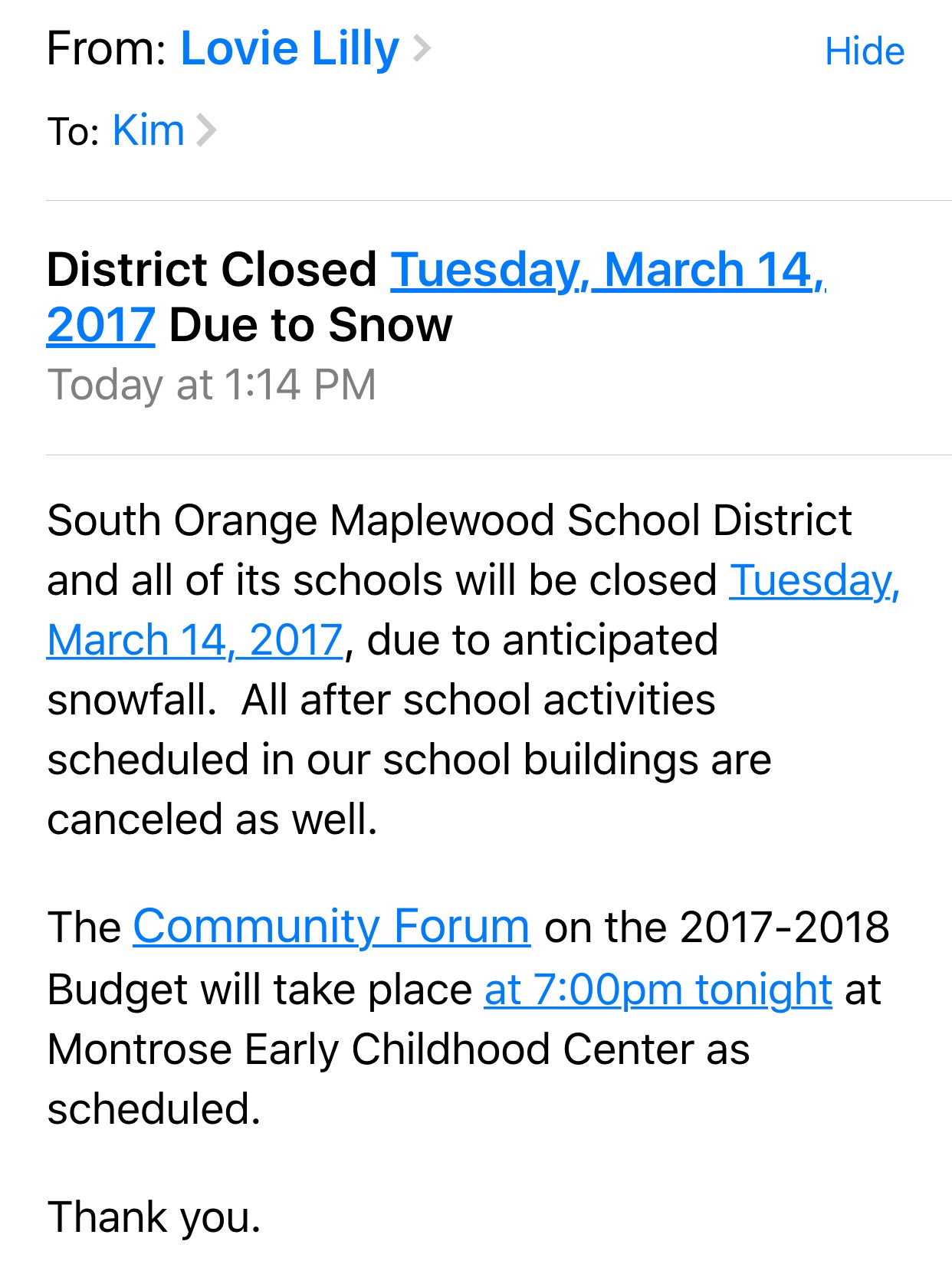
oakland2 said:
meganlibrarian said:
School's cancelled for tomorrow. Time for the kids to rejoice!
For which town? I'm in SOMA and haven't gotten any calls (yet)....
The email from SOMSD arrived in my inbox at 1:15pm.

No news on the Library yet but I did get a called from JOw D to stay off of country roads. And then this.
Posted on: March 13, 2017March 14th Winter Storm Stella
The
Township of South Orange Village Office of Emergency Management is
monitoring the impending Winter Storm Stella. Traveling Tuesday will be
hazardous for both the morning and evening commute with large amounts of
snow and blizzard like conditions expected. The indication is for
heavy, wet snow and snow packed on roadways with winds gusting to 30-35
mph range. The National Weather Services has warned of some possible
power outages. Please see detailed forecast below:
Weather:
PRECIPITATION
DEVELOPING AS: Snow ON (DAY): Tuesday AT APPROXIMATELY: 2-4am
ACCUMULATING SNOW OR SNOW/ICE OR ICE EXPECTED TO END: 4-6pm AT
APPROXIMATELY: Tuesday
FIRST INCH ON PAVEMENT EXPECTED BETWEEN: 3-5am
THREE INCHES ON PAVEMENT EXPECTED BETWEEN: 4-6am
SIX INCHES ON PAVEMENT EXPECTED BETWEEN: 5-7am
TOTAL SNOW ACCUMULATION: 14-21 INCHES
TOTAL ICE ACCUMULATION: Trace
TEMPERATURE
AT THE ONSET OF PRECIPITATION: 26-30 DEGREES AVERAGE TEMPERATURE DURING
PRECIPITATION: 30-34 DEGREES TEMPERATURE AT THE END OF PRECIPITATION:
30-34 DEGREES
AVERAGE WIND DIRECTION AND SPEED: NE/E 15-30 GUSTS TO 35 MPH
REMARKS:
Snow, heavy at times tomorrow into early tomorrow afternoon. Snow
continues tomorrow afternoon before tapering off to snow
showers/flurries tomorrow evening into Wednesday morning. Little
additional accumulation expected tomorrow night. Snow showers are
possible again Wednesday afternoon with up to an inch possible. Skies
clear our Wednesday night. Whiteout conditions likely at times tomorrow.
More weather information: http://www.google.org/publicalerts/alert?aid=c41ebc4e0744ab9b&hl=en&gl=US&source=wweather
SO Alerts: Emergency Alerts and Non-Emergency Notifications:
The Village's SOALERTS system allows residents to subscribe to our
notification service for all levels of Emergency Alerts as well as
subscribe to specific non-emergency Notifications covering a variety of
Village services and topics. Please update and check your subscription
to ensure that you are getting all requested notifications. https://nj-southorange.civicready.com/
Emergency Protocols:
On street parking is prohibited and travel is highly discouraged. If you
have an on street parking permit, please move your vehicle to the
nearest municipal lot.
If you have a fire hydrant in front of
your home please keep it clearly visible and accessible as it could save
your home – or even your life.
Residents are required to
clear snow as best as possible from their sidewalks within 12 daylight
hours following snowfall. Do not shovel snow into roadways, as it puts
emergency vehicles in danger. Please be careful when shoveling and take
frequent breaks.
Shoveling snow into the street is prohibited
and will result in the issuance of a summons which will require a court
appearance and fine.
Warming Centers/Sheltering
The South Orange Performing Arts Center (SOPAC) located at 1 SOPAC Way,
will be open as a warming center / shelter at 8 a.m. Tuesday, March
14th. If you need assistance in getting there, please contact SOPD at
973 763 3000.
Closings/Cancellations
Village Non-Essential Departments will be closed tomorrow March 14, 2017.
South
Orange Court Session for Tuesday, March 14, 2017 held in the Maplewood
Police and Court Building located at 1618 Springfield Ave, Maplewood, NJ
07040 has been cancelled.
Parking Authority:
Senior Bus Service will be cancelled tomorrow Tuesday, March 14th. Service will resume on Wednesday weather permitting.
All
Jitney Commuter Service will be cancelled tomorrow Tuesday, March 14th
(am, pm and late night). Service will resume on Wednesday weather
permitting.
All vehicles with On-Street parking permits must
move their vehicle(s) to the nearest municipal lot or the Third Street
Garage to allow for snow plowing.
All enforcement will be suspended during the storm.
The SOPA office will be closed on Tuesday, March 14th.
Any parking requests or issues should be called into the So Police Department at 973.763.3000.
The SOPA office and all services will resume on Wednesday weather permitting.
Third party reporting:
Please report any power outages to PSEG at: 1-800-436-PSEG (7734)
You can view the PSEG outage map: http://outagecenter.pseg.com/external/default.html
Additional information:
If there are power outages, the Village asks all residents and
neighborhood associations and groups to do their best to check on any
residents that may be elderly or have special needs
Emergency calls for police, fire or medical service will be triaged and high priority calls will be answered first
Non-emergency information and requests for service can be submitted via SOConnect at http://www.southorange.org/597/SO-Connect
or by downloading the app GovAlert on your mobile phone. Understand non
high priority requests may not be responded to immediately.
The
Police Department, Fire Department, Rescue Squad, Department of Public
Works and Office of Emergency Management are all staffed up to handle
emergent conditions throughout the duration of the storm and operations
are being coordinated through the Office of Emergency Management’s
Emergency.
Next update will be Monday, March 13, 2017 6 p.m.

Featured Events
-
Stephen Whitty Presents - Hometown Movie Stars: The Celebrated Actors Of CHS
May 6, 2024 at 7:00pm


Employment Wanted
Latest Jobs
Employment Wanted
-
Our amazing driving nanny is available for work.
Apr 28, 2024 at 8:05am
-
(NO FEES) Hire A Fresh Energetic Nanny/ Housekeeper Here ! (732)-737-7165
Apr 27, 2024 at 1:46am
-
(No Fees) Hire A Baby Nurse Here for Your New Borns! (732)-737-7165
Apr 27, 2024 at 1:46am
-
(NO Fees) Hire Housekeepers Here! ( 732)-737-7165
Apr 27, 2024 at 1:46am
-
(No Fees) Hire Home Health Aides Here! (732)-737-7165
Apr 27, 2024 at 1:46am
-
Summer Private Speech Therapist
Apr 26, 2024 at 9:12pm
-
Apr 26, 2024 at 1:58pm
-
(Classic Painting and Materials) Fair Prices. Spring and Summer Specials
Apr 25, 2024 at 5:14pm
Help Wanted
-
Part Time help for special needs young adult
Apr 27, 2024 at 4:43pm
-
Apr 25, 2024 at 6:15pm
Lessons/Instruction

Advertisement


Is there any way for her to try and catch an Amtrak back on Monday afternoon/evening? If I were in her shoes and had no Tuesday morning obligations, I'd probably try to head back early and beat the snow.