Tropical Storm Warning ENDED for the Jersey Shore and Eastern Essex County: Tropical Storm Hermine

Technically, the watch is for Eastern Essex County, which ends at the Irvington/Maplewood border. This is the watch statement:
HERMINE LOCAL WATCH/WARNING STATEMENT/ADVISORY NUMBER 21
NATIONAL WEATHER SERVICE NEW YORK NY AL092016
1207 PM EDT FRI SEP 2 2016
NJZ106-030000-
/O.NEW.KOKX.TR.A.1009.160902T1607Z-000000T0000Z/
EASTERN ESSEX-
1207 PM EDT FRI SEP 2 2016
...TROPICAL STORM WATCH IN EFFECT...
A TROPICAL STORM WATCH MEANS TROPICAL STORM WIND CONDITIONS ARE
POSSIBLE SOMEWHERE WITHIN THIS AREA AND WITHIN THE NEXT 48 HOURS
* LOCATIONS AFFECTED
- NEWARK
- BELLEVILLE
- NUTLEY
* WIND
- LATEST LOCAL FORECAST: BELOW TROPICAL STORM FORCE WIND
- PEAK WIND FORECAST: 10-20 MPH WITH GUSTS TO 30 MPH
- CURRENT THREAT TO LIFE AND PROPERTY: ELEVATED
- REMAIN BRACED AGAINST THE REASONABLE THREAT FOR TROPICAL
STORM FORCE WIND OF 39 TO 57 MPH.
- TO BE SAFE, EFFORTS SHOULD FULLY FOCUS ON AVOIDING INJURY.
PROPERTIES REMAIN SUBJECT TO LIMITED WIND IMPACTS.
- NOW IS THE TIME TO HIDE FROM THE WIND. FAILURE TO
ADEQUATELY SHELTER MAY RESULT IN SERIOUS INJURY. REMAIN
SHELTERED UNTIL THE HAZARDOUS WIND SUBSIDES.
- POTENTIAL IMPACTS: UNFOLDING
- POTENTIAL IMPACTS FROM THE MAIN WIND EVENT ARE UNFOLDING.
- THE EXTENT OF REALIZED IMPACTS WILL DEPEND ON THE ACTUAL
STRENGTH, DURATION, AND EXPOSURE OF THE WIND AS EXPERIENCED
AT PARTICULAR LOCATIONS.
* STORM SURGE
- LATEST LOCAL FORECAST: LIFE-THREATENING STORM SURGE POSSIBLE
- PEAK STORM SURGE INUNDATION: THE POTENTIAL FOR 2-4 FEET
ABOVE GROUND SOMEWHERE WITHIN SURGE PRONE AREAS
- WINDOW OF CONCERN: BEGINS SATURDAY EVENING
- CURRENT THREAT TO LIFE AND PROPERTY: MODERATE
- EMERGENCY PLANS SHOULD INCLUDE A REASONABLE THREAT FOR
DANGEROUS STORM SURGE FLOODING OF GREATER THAN 3 FEET ABOVE
GROUND.
- TO BE SAFE, EARNESTLY PREPARE FOR THE POTENTIAL OF
SIGNIFICANT STORM SURGE FLOODING IMPACTS. EVACUATION
EFFORTS SHOULD NOW BE BROUGHT TO COMPLETION. EVACUATIONS
MUST BE COMPLETE BEFORE DRIVING CONDITIONS BECOME UNSAFE.
- LIFE THREATENING INUNDATION IS POSSIBLE. FAILURE TO HEED
EVACUATION ORDERS MAY RESULT IN SERIOUS INJURY OR LOSS OF
LIFE. LEAVE IF EVACUATION ORDERS ARE GIVEN FOR YOUR AREA.
CONSIDER VOLUNTARY EVACUATION IF RECOMMENDED. POOR
DECISIONS MAY NEEDLESSLY RISK LIVES.
- POTENTIAL IMPACTS: SIGNIFICANT
- AREAS OF INUNDATION WITH STORM SURGE FLOODING ACCENTUATED
BY WAVES. DAMAGE TO SEVERAL BUILDINGS, MAINLY NEAR THE
COAST.
- SECTIONS OF NEAR-SHORE ESCAPE ROUTES AND SECONDARY ROADS
BECOME WEAKENED OR WASHED OUT, ESPECIALLY IN USUALLY
VULNERABLE LOW SPOTS.
- FLOOD CONTROL SYSTEMS AND BARRIERS MAY BECOME STRESSED.
- MAJOR BEACH EROSION WITH HEAVY SURF BREACHING DUNES. VERY
DANGEROUS SURF AND RIP CURRENTS.
- MODERATE DAMAGE TO MARINAS, DOCKS, BOARDWALKS, AND PIERS.
SEVERAL SMALL CRAFT BROKEN AWAY FROM MOORINGS, ESPECIALLY
IN UNPROTECTED ANCHORAGES.
* FLOODING RAIN
- LATEST LOCAL FORECAST:
- PEAK RAINFALL AMOUNTS: AROUND 1 INCH
- CURRENT THREAT TO LIFE AND PROPERTY: NONE
- EMERGENCY CONSIDERATIONS NEED NOT INCLUDE A THREAT FOR
RAINFALL FLOODING. LOCALLY HEAVY RAIN AND NUISANCE FLOODING
MAY STILL OCCUR.
- LITTLE TO NO PREPARATIONS NEEDED TO GUARD AGAINST EXCESSIVE
TROPICAL RAINFALL.
- ENSURE READINESS FOR THE NEXT TROPICAL RAINFALL EVENT.
- POTENTIAL IMPACTS: LITTLE TO NONE
- LITTLE TO NO POTENTIAL IMPACTS FROM FLOODING RAIN.
* TORNADO
- LATEST LOCAL FORECAST:
- SITUATION IS UNFAVORABLE FOR TORNADOES
- CURRENT THREAT TO LIFE AND PROPERTY: NONE
- EMERGENCY CONSIDERATIONS NEED NOT INCLUDE A THREAT FOR
TORNADOES. SHOWERS AND THUNDERSTORMS WITH STRONG GUSTY
WINDS MAY STILL OCCUR.
- LITTLE TO NO PREPARATIONS NEEDED TO GUARD AGAINST TROPICAL
TORNADOES.
- ENSURE READINESS FOR THE NEXT TROPICAL TORNADO EVENT.
- POTENTIAL IMPACTS: LITTLE TO NONE
- LITTLE TO NO POTENTIAL IMPACTS FROM TORNADOES.
* FOR MORE INFORMATION:
- HTTP://WWW.ESSEXSHERIFF.COM/INDEX.PHP?OPTION=COM_CONTENT&TASK=CATEGORY&SECTIONID=10&ID=21&ITEMID=64
- HTTP://WEATHER.GOV/NYC
- HTTP://READY.GOV/HURRICANES
In MAPSO, this is our Hurricane Statement:
Hurricane Local Statement
TROPICAL STORM HERMINE LOCAL STATEMENT ADVISORY NUMBER 20
DEZ001>004-MDZ008-012-015-019-020-NJZ001-007>010-012>027-PAZ054-055-060>062-070-071-101>106-021830-
TROPICAL STORM HERMINE LOCAL STATEMENT ADVISORY NUMBER 20
NATIONAL WEATHER SERVICE MOUNT HOLLY NJ AL092016
623 AM EDT FRI SEP 2 2016
THIS PRODUCT COVERS NEW JERSEY...DELAWARE...SOUTHEASTERN PENNSYLVANIA AND NORTHEAST MARYLAND.
**TROPICAL STORM HERMINE WILL IMPACT THE REGION OVER LABOR DAY WEEKEND AND POSSIBLY INTO THE MIDDLE OF NEXT WEEK**
NEW INFORMATION
---------------
* CHANGES TO WATCHES AND WARNINGS:
- NONE
* CURRENT WATCHES AND WARNINGS:
- A TROPICAL STORM WATCH REMAINS IN EFFECT FOR INLAND
SUSSEX...DELAWARE BEACHES...WESTERN MONMOUTH...EASTERN
MONMOUTH...OCEAN...ATLANTIC...CAPE MAY...ATLANTIC COASTAL CAPE
MAY...COASTAL ATLANTIC...COASTAL OCEAN AND SOUTHEASTERN
BURLINGTON
* STORM INFORMATION:
- ABOUT 780 MILES SOUTHWEST OF ATLANTIC CITY NJ OR ABOUT 730
MILES SOUTHWEST OF DOVER DE
- 30.8N 83.6W
- STORM INTENSITY 70 MPH
- MOVEMENT NORTH-NORTHEAST OR 25 DEGREES AT 14 MPH
SITUATION OVERVIEW
------------------
HERMINE MADE LANDFALL IN FLORIDA LAST NIGHT AND HAS WEAKENED. AS A RESULT,
IT HAS BEEN DOWNGRADED TO A TROPICAL STORM. HERMINE IS EXPECTED TO MOVE
NORTHEASTWARD INTO THE CAROLINAS ON SATURDAY AND OFF THE MID-ATLANTIC COAST
SATURDAY NIGHT. THE STORM IS THEN EXPECTED TO STALL OFF THE COAST SUNDAY AND
MONDAY BEFORE GRADUALLY MOVING AWAY FROM THE AREA DURING THE MIDDLE
OF NEXT WEEK.
A TROPICAL STORM WATCH REMAINS IN EFFECT FOR PORTIONS OF THE MID-
ATLANTIC COAST INCLUDING SOUTHERN DELAWARE AND COASTAL NEW JERSEY FROM
CAPE MAY TO SANDY HOOK. THIS WATCH ALSO INCLUDES COASTAL WATERS AND
THE LOWER DELAWARE BAY. SUSTAINED TROPICAL STORM FORCE WINDS ARE
POSSIBLE OVER IMMEDIATE COASTAL AREAS INCLUDING COASTAL WATERS AND
TOWARD THE LOWER DELAWARE BAY. SOME TROPICAL STORM FORCE GUSTS ARE
POSSIBLE FARTHER INLAND.
HAZARDOUS SEAS AND DANGEROUSLY ROUGH SURF CAN BE EXPECTED
THROUGHOUT THE HOLIDAY WEEKEND AND POSSIBLY INTO THE MIDDLE OF NEXT
WEEK. A MODERATE TO HIGH RIP CURRENT RISK CAN BE EXPECTED AT THE
BEACHES DURING THIS TIME.
MINOR TO MODERATE COASTAL FLOODING IS POSSIBLE AROUND THE TIMES OF
HIGH TIDE FROM LATE SATURDAY ONWARD. SOME LOCALIZED MAJOR COASTAL
FLOODING CAN NOT BE RULED OUT, ESPECIALLY IN THE BACK BAYS WHERE
WATER ACCUMULATES WITH EACH SUCCESSIVE HIGH TIDE. THE MAGNITUDE OF
THE COASTAL FLOODING WILL ULTIMATELY DEPEND ON THE PATH AND
STRENGTH OF THE STORM. THERE IS A POTENTIAL FOR MORE THAN 2 INCHES
OF RAINFALL. SOME AREAS NEAR THE COAST IN DELAWARE AND SOUTHERN NEW
JERSEY MAY RECEIVE 4 TO 6 INCHES WITH LOCALLY HIGHER AMOUNTS,
WHICH COULD LEAD TO FLOODING.
POTENTIAL IMPACTS
-----------------
* WIND:
PREPARE FOR HAZARDOUS WIND HAVING POSSIBLE LIMITED IMPACTS ACROSS NEW
JERSEY...DELAWARE...SOUTHEASTERN PENNSYLVANIA AND NORTHEAST
MARYLAND.. POTENTIAL IMPACTS INCLUDE:
- DAMAGE TO PORCHES, AWNINGS, CARPORTS, SHEDS, AND UNANCHORED
MOBILE HOMES IS POSSIBLE. UNSECURED LIGHTWEIGHT OBJECTS COULD
BE BLOWN AROUND.
- MANY LARGE TREE LIMBS MAY BE BROKEN OFF. A FEW TREES COULD BE
SNAPPED OR UPROOTED. SOME FENCES AND ROADWAY SIGNS MAY BE BLOWN
OVER.
- A FEW ROADS COULD BE IMPASSABLE FROM DEBRIS. HAZARDOUS DRIVING
CONDITIONS ARE POSSIBLE ON BRIDGES AND OTHER ELEVATED ROADWAYS.
- SCATTERED POWER AND COMMUNICATIONS OUTAGES ARE POSSIBLE.
* SURGE:
PREPARE FOR LOCALLY HAZARDOUS SURGE HAVING POSSIBLE LIMITED IMPACTS
ACROSS COASTAL LOCATIONS OR AREAS PRONE TO TIDAL FLOODING, INCLUDING
THE BACK BAYS. POTENTIAL IMPACTS IN THIS AREA INCLUDE:
- LOCALIZED INUNDATION IS POSSIBLE WITH STORM SURGE FLOODING
MAINLY ALONG IMMEDIATE SHORELINES AND IN LOW-LYING SPOTS, OR IN
AREAS FARTHER INLAND NEAR WHERE HIGHER SURGE WATERS MOVE ASHORE.
- SECTIONS OF NEAR-SHORE ROADS AND PARKING LOTS COULD BECOME
OVERSPREAD WITH SURGE WATER. DANGEROUS DRIVING CONDITIONS ARE
POSSIBLE IN PLACES WHERE SURGE WATER COVERS THE ROAD.
- MODERATE BEACH EROSION IS EXPECTED. HEAVY SURF ALSO BREACHING
DUNES, MAINLY IN USUALLY VULNERABLE LOCATIONS. STRONG RIP
CURRENTS ARE ANTICIPATED.
- MINOR TO LOCALLY MODERATE DAMAGE TO MARINAS, DOCKS, BOARDWALKS,
AND PIERS IS POSSIBLE. A FEW SMALL CRAFT MAY BE BROKEN AWAY
FROM MOORINGS.
THERE IS A POTENTIAL FOR TIDAL FLOODING FARTHER UP THE DELAWARE
BAY AND DELAWARE RIVER. SEEMINGLY MINOR SHIFTS TO THE STORM TRACK
COULD LEAD TO CONSIDERABLE CHANGES TO THE COASTAL FLOODING
POTENTIAL. ELSEWHERE ACROSS NEW JERSEY...DELAWARE...SOUTHEASTERN
PENNSYLVANIA AND NORTHEAST MARYLAND., LITTLE TO NO IMPACT IS
ANTICIPATED.
* FLOODING RAIN:
PREPARE FOR LOCALLY HAZARDOUS RAINFALL FLOODING HAVING POSSIBLE
LIMITED IMPACTS ACROSS THE COASTAL PLAIN. POTENTIAL
IMPACTS INCLUDE:
- LOCALIZED RAINFALL FLOODING MAY PROMPT A FEW EVACUATIONS.
- RIVERS AND TRIBUTARIES MAY QUICKLY RISE WITH SWIFTER CURRENTS.
SMALL STREAMS, CREEKS, CANALS, AND DITCHES MAY BECOME SWOLLEN
AND OVERFLOW IN SPOTS.
- FLOOD WATERS CAN ENTER A FEW STRUCTURES, ESPECIALLY IN
VULNERABLE SPOTS. RAPID PONDING OF WATER MAY OCCUR AT
UNDERPASSES, LOW-LYING SPOTS, AND POOR DRAINAGE AREAS. SEVERAL
STORM DRAINS AND RETENTION PONDS BECOME NEAR-FULL AND BEGIN TO
OVERFLOW. SOME BRIEF ROAD AND BRIDGE CLOSURES ARE POSSIBLE.
ELSEWHERE ACROSS NEW JERSEY...DELAWARE...SOUTHEASTERN PENNSYLVANIA
AND NORTHEAST MARYLAND., LITTLE TO NO IMPACT IS ANTICIPATED.
PRECAUTIONARY/PREPAREDNESS ACTIONS
----------------------------------
* OTHER PREPAREDNESS INFORMATION:
NOW IS THE TIME TO CHECK YOUR EMERGENCY PLAN AND TAKE NECESSARY
ACTIONS TO SECURE YOUR HOME OR BUSINESS. DELIBERATE EFFORTS SHOULD BE
UNDERWAY TO PROTECT LIFE AND PROPERTY. ENSURE THAT YOUR EMERGENCY
SUPPLIES KIT IS STOCKED AND READY.
WHEN MAKING SAFETY AND PREPAREDNESS DECISIONS, DO NOT FOCUS ON THE
EXACT FORECAST TRACK AS THERE ARE INHERENT FORECAST UNCERTAINTIES
WHICH MUST BE TAKEN INTO ACCOUNT.
IF YOU LIVE IN A PLACE PARTICULARLY VULNERABLE TO FLOODING, SUCH AS
NEAR THE OCEAN, IN A LOW LYING OR POOR DRAINAGE AREA, IN A VALLEY, OR
NEAR AN ALREADY SWOLLEN RIVER, PLAN TO MOVE TO SAFE SHELTER ON HIGHER
GROUND
ALWAYS HEED THE ADVICE OF LOCAL OFFICIALS AND COMPLY WITH ANY ORDERS
THAT ARE ISSUED. DO NOT NEEDLESSLY JEOPARDIZE YOUR LIFE OR THE LIVES
OF OTHERS.
WHEN SECURING YOUR PROPERTY, OUTSIDE PREPARATIONS SHOULD BE CONDUCTED
AS SOON AS POSSIBLE BEFORE CONDITIONS DETERIORATE. THE ONSET OF
STRONG GUSTY WINDS AND HEAVY RAIN CAN CAUSE CERTAIN PREPAREDNESS
ACTIVITIES TO BECOME UNSAFE.
BE SURE TO LET FRIENDS AND OTHER FAMILY MEMBERS KNOW OF YOUR
INTENTIONS AND WHEREABOUTS FOR SURVIVING THE STORM. FOR EMERGENCY
PURPOSES, HAVE SOMEONE LOCATED AWAY FROM THE THREATENED AREA SERVE AS
YOUR POINT OF CONTACT. SHARE VITAL CONTACT INFORMATION WITH OTHERS.
KEEP CELL PHONES HANDY AND WELL CHARGED.
VISITORS TO THE AREA SHOULD BECOME FAMILIAR WITH NEARBY SURROUNDINGS.
IF YOU ARE A VISITOR, KNOW THE NAME OF THE COUNTY IN WHICH YOU ARE
LOCATED AND WHERE IT IS RELATIVE TO CURRENT WATCHES AND WARNINGS. IF
STAYING AT A HOTEL, ASK THE MANAGEMENT STAFF ABOUT THEIR ONSITE
DISASTER PLAN. LISTEN FOR EVACUATION ORDERS, ESPECIALLY PERTAINING TO
AREA VISITORS.
CLOSELY MONITOR NOAA WEATHER RADIO OR OTHER LOCAL NEWS OUTLETS FOR
OFFICIAL STORM INFORMATION. LISTEN FOR POSSIBLE CHANGES TO THE
FORECAST.
* ADDITIONAL SOURCES OF INFORMATION:
- FOR INFORMATION ON APPROPRIATE PREPARATIONS SEE READY.GOV
- FOR INFORMATION ON CREATING AN EMERGENCY PLAN SEE GETAGAMEPLAN.ORG
- FOR ADDITIONAL DISASTER PREPAREDNESS INFORMATION SEE REDCROSS.ORG
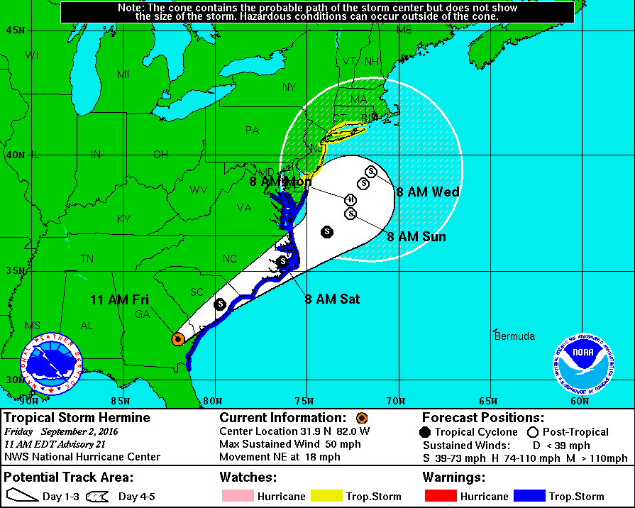
With the 11am advisory, the NHC extended the warnings up the coast as far as Delaware, and the watches as far north as Connecticut. The forecast now indicates that Hermine is likely to regain Hurricane strength for a period on Monday, while likely to remain well offshore. These two things go together -- if the storm tracks further inland, it will not gain strength but the net effect of an inland track on us could be more rain rather than less.
Hermine is currently over southeast Georgia heading northeast, heading back out to sea over coastal South Carolina sometime later today..


So what are the chances by Sunday 9pm flight from JFK to Europe is not cancelled? 50/50?

it really doesn't look like it's going to impact us much at all. Even rain for Sunday is only 50% chance.im going to bet you'll be fine.

I'll ask: Max, are "the weather officials" anticipating that we will see the effects of this Sunday afternoon/evening? We will be on the road back from Mass. and want to leave early enough to avoid trouble.

According to this website it doesn't seem that bad at all. However, the tv news just now suggested a windy, rainy, strong rip-tide/dangerouse swimming and likely flooding weekend through Monday along the Shore.
anniesimms - here's the same site's forecast for Boston, if that is helpful.
That's mainly for the Jersey shore. It really looks like all we'll be seeing is possibly some wind and rain but nothing significant.


Let it rain Monday. I have to work and I'd love to get one more good weekend in at my pool!
Forecasting the exact effects of this storm on our immediate area is going to be difficult, at least for the next 24 - 36 hours.
The most likely scenario is that we get rain and wind, neither of tropical storm force, Sunday night, then sporadically through Tuesday night. There is a possibility weather could arrive as early as tomorrow night, and last through Wednesday, but these are less than 50% possibilities. An actual tropical storm-level strike on the SOMA area is right now at just under a 50% possibility for wind and much less than that for rain.
The situation for the airports is more serious, as higher altitude winds will be more effected, and it is possible that all offshore flight paths, and perhaps even many coastal routes, will be closed for two or three days. The impact over that time period is beyond my ability to forecast, but it could be ugly.
At this time, I would be very careful regarding mass media forecasts, as the effects of the storm are not only unpredictable but will vary greatly throughout our region depending on the storm track. The current track is being forecast to be significantly affected by two other systems. For the track to perform in any given way, all three systems have to conform to model projections, which is unlikely to happen. In most scenarios, this storm will return to hurricane strength off the New Jersey Coast for a period during the day on Monday. Please pay attention to the radio or other reliable source of information during this period. Please be alert for warnings, and please don't just depend on me!
Make sure any source you are following for updates during the Sunday - Tuesday period are (1) forecasting for western Essex County (there could be a significant difference in the effects of the storm between here and Long Island, or even Newark Airport), and (2) that they are coming from either the National Weather Service or National Hurricane Center (it is ok if they are coming through a third party or Facebook weather site as long as they originate with NOAA).
~~~~~~~~~~~~~~~~~~~~~~~~~~~~
You may remember during Sandy there were problems with watches and warnings because, as the storm moved north, it technically became a post-tropical storm, and for bullsh*t technical reasons was no longer the responsibility of the NHC. As a result, a$$e$ were kicked and names were taken, and we have been assured that no such foolishness will recur. NHC will track the storm for its entire duration and issue watches and warnings as needed.
~~~~~~~~~~~~~~~~~~~~~~~~~~~~
The responsible thing to do at this point is go forward with your weekend plans but be aware the potential exists that you will have to react to this storm, and that there is a small but very real possibility that the storm could be a very serious one for us.

This is gonna sound stupid. We're supposed to be in a rental beachfront house in South Bethany, DE tomorrow, for a week. We're supposed to have family from Philly coming overnight on Sunday into Monday.
That said, I vote to ride things out HERE, rather than in a storm-besieged rental... and head South when it's not CRAZY to do so, for the remaining days of our "vacation". Am I stupid, Max?
-s


Anyone know the best way to get up-to-date info about transit - in particular NJT and LIRR, since that will be our way to get to and from the US Open? We have tickets to Ashe Stadium, so (thanks to the new roof), rain alone shouldn't be a huge problem. I assume that if we are there we will get warning if we should leave.
soda said:
This is gonna sound stupid. We're supposed to be in a rental beachfront house in South Bethany, DE tomorrow, for a week. We're supposed to have family from Philly coming overnight on Sunday into Monday.
That said, I vote to ride things out HERE, rather than in a storm-besieged rental... and head South when it's not CRAZY to do so, for the remaining days of our "vacation". Am I stupid, Max?
-s
I can't tell you what to do -- you have to know your own level of comfort with risk. there is a very real possibility you will be evacuated. I don't know the area you are talking about, though. Is is under a Trop Storm Warning right now?
Update -- with the 8pm advisory, all of the Delaware coast is under a warning. If it were me, I would go, but then I would be going to see the storm! ;-) Normal people should probably stay home.
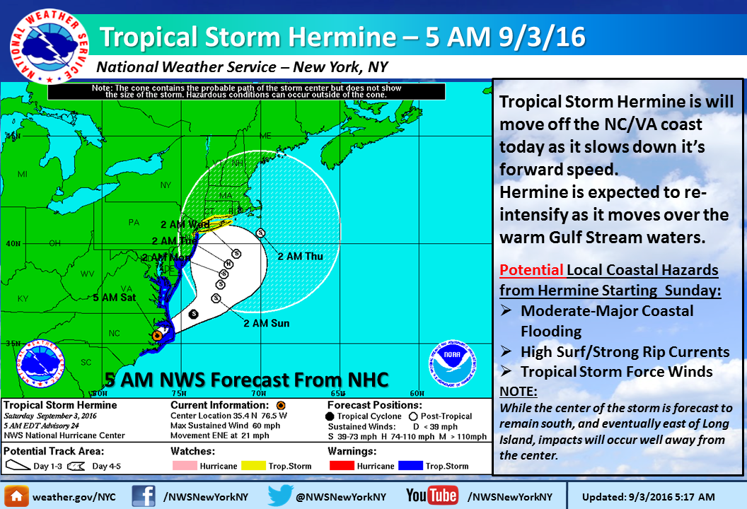
With this evening's guidence, possibility of TS Hermine making landfall on the Jersey shore have marginally increased, and the storm watch has been upgraded to a warning. This is still explicitly only for the shore, but are instructive for us as well.

The roof will not be much help if wind conditions are serious enough for you to get a warning to leave the stadium as opposed to waiting out the storm in place. Were conditions to get that serious, it is likely that public transit will have stopped running and there will not be a safer place with large enough capacity for you and everyone else in the stadium to get to safely. Chances are, the event will be postponed or canceled if weather conditions are expected get that bad by the time the event would begin.
sac said:
We have tickets to Ashe Stadium, so (thanks to the new roof), rain alone shouldn't be a huge problem. I assume that if we are there we will get warning if we should leave.
In this morning's guidance, TS Hermine has tracked further east, more out to sea, in the Sunday/Monday timeframe. This lowers the chance of landfall on the Jersey shore. There is also less chance of gale force winds and flooding in the local area.
None the less, high surf and dangerous tides are almost a certainty Sunday - Tuesday at the shore.
Tropical Storm Hermine crossed back over water near Cape Lookout, North Carolina, a short whilr ago. The storm should track northeast, just off the coast, gaining strength, until stalling off Virginia early Sunday morning. Hermine will then move very slowly northeast for several days.
The most likely effects in our SOMA area would be heavy rain Sunday night and Monday. Rain is possible, however, through Tuesday or even Wednesday if the track shifts. High winds are also possible in this time frame, though most likely Monday.

I am in MD for the weekend and planning to drive back to NJ in the early afternoon on Sunday. Hoping to make it back to Maplewood by 5-6pm. Will the I-95 corridor be ok driving-wise with respect to Hermine?

Suggestion --- not weather related. Get off of 95 after you leave the Del. Mem. bridge. Take 295 north to Trenton and then take 195 to turnpike. Save yourself a few $$
julieK said:
I am in MD for the weekend and planning to drive back to NJ in the early afternoon on Sunday. Hoping to make it back to Maplewood by 5-6pm. Will the I-95 corridor be ok driving-wise with respect to Hermine?
Probably. Might get some rain and gusts.
Does it look like we will at least get some very needed rain? If so, any idea of when and how much?
Thanks!
Forecast still on track.
Key elements:
-- Stay away from the shore, the tidal surge will be significant, especially with the overnight tides tonight through the second full tide Monday.
-- Effects inland in the MAPSO area are likely to be moderate but there is a real chance of heavy rain if one of the bands swings over us. There is also a real chance we will get little or nothing. The middle ground, that Sunday night through Monday morning have periods of rain and wind but nothing catastrophic, is the most likely but not the only plausible scenario.
-- There is a better than 50/50 chance of gusty winds in the 30 - 40 mph range.
-- As I said before, unless you are going down the shore, I wouldn't worry too much about this storm being an Irene- or Sandy-level crises, but normal nor'easter prudence is called for. Don't have more people over Monday than you can fit in the house. Have water and candles available (you should always do this anyway) in case the power goes out for a few hours. Pay attention to the local weather.
-- Local weather means right here, or Newark, as a storm like this can have very different effects between here and Long Island, or even the city.
~~~~~~~~~~~~~~~~~~
One of the many models is projecting the storm to take a very different track, hooking in and making landfall on the Jersey shore. The NWS is discounting that guidance as all other models are tightly clustered around an offshore track east of us and south of Long Island. I would not even mention this except the outlier is the Euro, and many meteorologists take the Euro very seriously. One usually reliable internet weather site has been calling for coastal evacuations based on this model alone. If the guidance was supported, in any way, by any other model, I would include it in my thinking, but I have to agree with the NWS here that the likelihood that the Euro, and the Euro alone, has this right and every other model is 200 miles off on the track, is very slim. That said, you will hear about it if you follow commercial weather forecasters, and you can choose to take this information as seriously as you feel is prudent.
Wasn't the Euro the model that accurately predicted the track of Hurricane Joaquin last year when most other models were predicting a direct hit on NYC/NJ?

bluepool said:
Wasn't the Euro the model that accurately predicted the track of Hurricane Joaquin last year when most other models were predicting a direct hit on NYC/NJ?
Yes, but as you said, it was most, not all, models going the other way. If this weren't the Euro, it would not even deserve a mention, but it still has zero support from any other model.
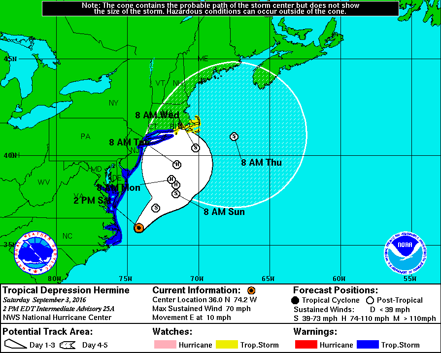
With the eight o'clock guidence, the models have diverged some from their earlier consensus, with the Euro now trending more to the east (away from us) and faster, and the GFS and the UKMet slower and more westward. The graphic (posted below) shows a middle path.
The good news is this now takes the Euro away from its position of forecasting a potential landfall or major sideswipe of New Jersey. It is not reassuring, though, to have the models diverging on an active storm as it runs up the coast.
Here are the key points from the latest NHC discussion:
"1. The slow motion and large wind field associated with Hermine will result in a long duration of hazardous conditions along much of the mid-Atlantic coast extending into southern New England through the holiday weekend and into midweek.
2. Small changes in the meandering track of Hermine could result in large differences in the impacts along the mid-Atlantic coast during the next several days. In addition, there could be multiple occurrences of tropical storm conditions in some locations within the warning area during this time.
3. Although Hermine has become a post-tropical cyclone, NHC will continue to issue its full suite of advisory and warning products as long as the system remains a significant threat to land areas."
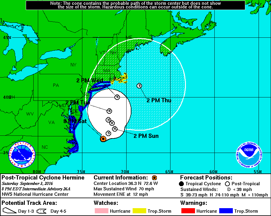
Somrthing to note about the graphic is the sheer size of the 5 day cone of uncertainty, which now again includes significant inland areas including MAPSO.

Featured Events


Employment Wanted
Latest Jobs
Employment Wanted
-
Math Tutoring with Certified Teacher
May 7, 2024 at 7:16pm
-
On call house cleaning service
May 6, 2024 at 7:17pm
-
May 6, 2024 at 10:11am
-
Experienced Summer Nanny Available: Thursdays & Fridays ;)
May 6, 2024 at 8:56am
-
Brazilian cleaning 973 776 2481
May 5, 2024 at 7:35pm
Help Wanted
-
HF801 PT Nanny for 1 Infant (ASAP)
May 9, 2024 at 1:18pm
-
Very Rewarding Position as a Dog Walker/Pet Sitter
May 8, 2024 at 11:37am
-
SF5002 PT or FT Nanny/FA for 3 (Aug/Sept Start)
May 8, 2024 at 10:59am
-
CF583 PT Nanny for 2 (July Start)
May 7, 2024 at 2:07pm
-
May 7, 2024 at 7:32am
Lessons/Instruction

Advertisement


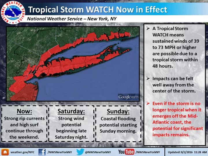
Tropical Storm Watch for our area