Winter Storm Warning - Wednesday Dec 16 into Thursday Dec 17


bikefixed said:
drummerboy said:
Now that I take a closer look, the big brown splotch looks like a vulture.
Perhaps one of the more astute assessments from those of us not Wx-ucated. ;-)
Thank you. I do my best.

I think that WxNut2.0's definition of "failure mode" and mine are not really the same thing.

Definitely a well pronounced jog north on the 12z GFS. Still bringing about 1.5" liquid QPF (in this case, about 10" of snow) to Maplewood on this run, but wouldn't need much more of a northward push to get us into mostly rain.

HatsOff said:
I think that WxNut2.0's definition of "failure mode" and mine are not really the same thing.
Fair -- you should see me during tornado season.
Now that the morning suite of models has come in, I'm really starting to be of the belief that the worst of this thing will be to our north. Right now I'm thinking Maplewood picks up in the ballpark of 6-10 inches. We would need either a persistent band of heavy snow (very hard to predict until pretty much as it's occurring) or quick reversal of the northwest trend in order for higher totals to be realized.
Of note, the ECMWF is a holdout on the northwest trend and slams maplewood with a foot plus. I'm not sold however as I think it's not doing a great job initializing the current observations.


The NWS has issued a WINTER STORM WARNING for our area from Wednesday at 2:00 pm until Thursday at 1:00pm
Winter Storm Warning
URGENT - WINTER WEATHER MESSAGE
National Weather Service New York NY
340 PM EST Tue Dec 15 2020

CTZ005>010-NJZ002-004-103>108-NYZ067>071-161200-
/O.UPG.KOKX.WS.A.0001.201216T1900Z-201217T1800Z/
/O.NEW.KOKX.WS.W.0001.201216T1900Z-201217T1800Z/
Northern Fairfield-Northern New Haven-Northern Middlesex-
Northern New London-Southern Fairfield-Southern New Haven-
Western Passaic-Eastern Passaic-Western Bergen-Eastern Bergen-
Western Essex-Eastern Essex-Western Union-Eastern Union-Orange-
Putnam-Rockland-Northern Westchester-Southern Westchester-
340 PM EST Tue Dec 15 2020

...WINTER STORM WARNING IN EFFECT FROM 2 PM WEDNESDAY TO 1 PM EST
THURSDAY...

* WHAT...Heavy snow expected. Total snow accumulations of 12 to 16
  inches. Winds gusting as high as 45 mph along the coast.

* WHERE...Portions of northeast New Jersey, southern Connecticut
  and southeast New York, including the Lower Hudson Valley.

* WHEN...From 2 PM Wednesday to 1 PM EST Thursday.

* IMPACTS...Travel could be very difficult to impossible. The
  hazardous conditions could impact the morning or evening
  commute. Gusty winds and heavy wet snow could bring down
  scattered to numerous tree branches along the coast.

PRECAUTIONARY/PREPAREDNESS ACTIONS...

If you must travel, keep an extra flashlight, food, and water in
your vehicle in case of an emergency.

Check local Department of Transportation information services for
the latest road conditions.
I am thoroughly shocked at the moment that the NWS is sticking with 12-16. But they know better than me and I’ll happily defer to them.
I have been playing with my favorite swirly-color toy, Ventusky, and it is pretty fun. Click on "snow cover" starting tomorrow at noon-ish then turn on the animation and watch the snow pile up over the east coast. Cool!! Also you can click on "precipitation" instead and watch the storm run up the east coast. You can see how fast it is predicted to go.
FWIW they have our total at about 6". The weather guys can probably figure out which model(s) they are using. I like Ventusky's total a lot better than NWS. And I mean that the normal way - I like it. To me, meteorology is a valuable but completely inscrutable art. I respect it but by no means understand it.
HatsOff said:
I have been playing with my favorite swirly-color toy, Ventusky, and it is pretty fun. Click on "snow cover" starting tomorrow at noon-ish then turn on the animation and watch the snow pile up over the east coast. Cool!! Also you can click on "precipitation" instead and watch the storm run up the east coast. You can see how fast it is predicted to go.
FWIW they have our total at about 6". The weather guys can probably figure out which model(s) they are using. I like Ventusky's total a lot better than NWS. And I mean that the normal way - I like it. To me, meteorology is a valuable but completely inscrutable art. I respect it but by no means understand it.
Hmmm it looks like they have an “automatic” setting for which model they use. I’d imagine that the GFS or NAM, but not sure (and again I’d caution not to pay too much attention to what snow totals it shows!). Cool little tool!
As to your last point about it being an art that’s difficult to understand, when I was going for my PhD I had to take an exam to get into the program. My roommate and I had an inkling on what one of the questions would be so we practiced it on a 4’x6’ whiteboard until it was muscle memory. Thankfully we were right and it showed up. This was it. And I’m not sure I understand it anymore.
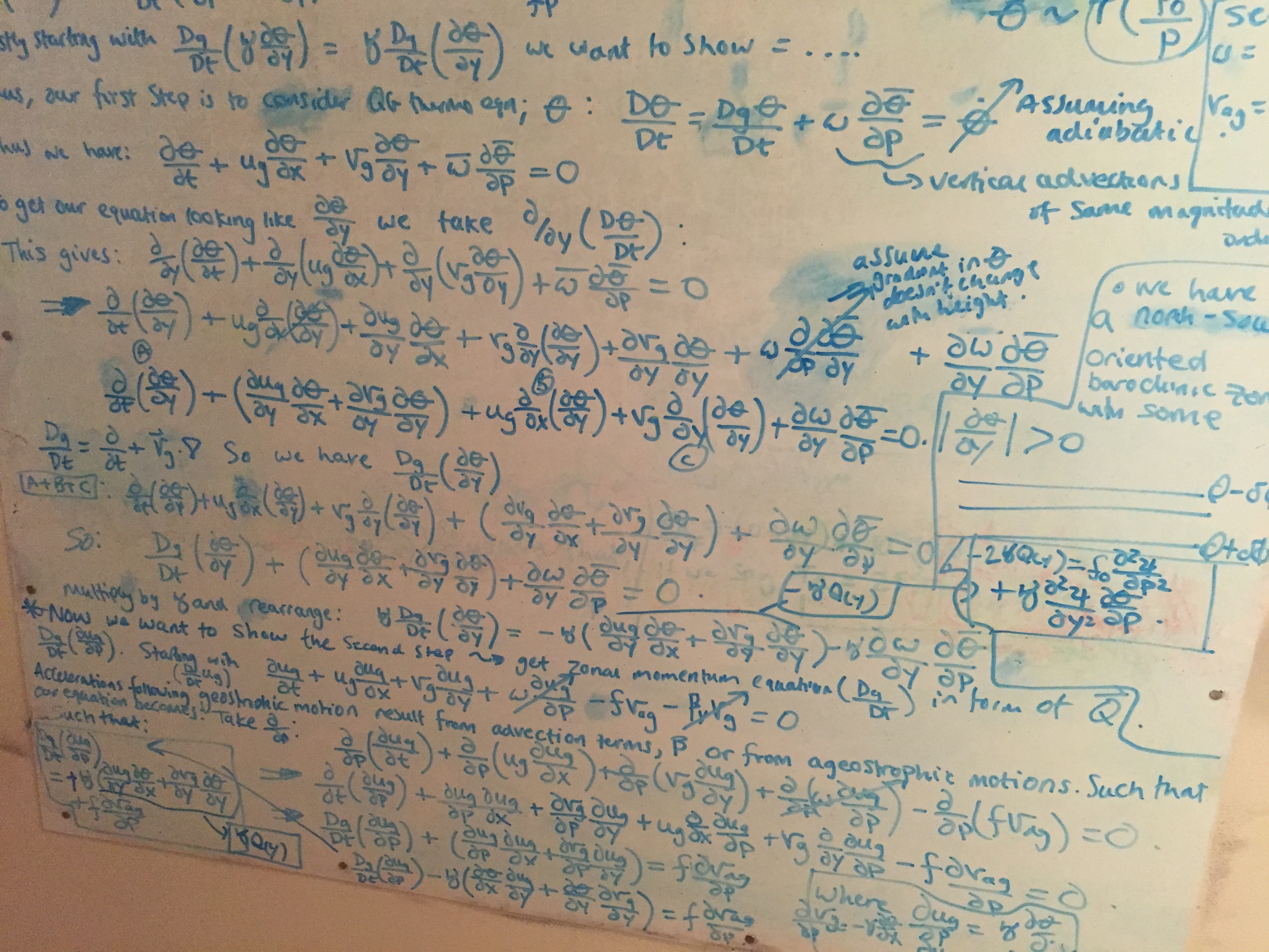

Impressive!!
One of the great things about reading these weather threads is seeing the true & geeky (in all the best ways) love for the science. You have to love it to study that intensely, and it comes across in other ways, too.
I ran into the end of my advanced science career when I could not understand differential equations as seen in the above post. Some friends said it was not hard, but I never got it. Hats off to those who understand this math.

Check the very nice intro into differential equations at https://youtube.com/playlist?list=PLZHQObOWTQDNPOjrT6KVlfJuKtYTftqH6
RobertRoe said:
I ran into the end of my advanced science career when I could not understand differential equations as seen in the above post. Some friends said it was not hard, but I never got it. Hats off to those who understand this math.
RobertRoe said:
I ran into the end of my advanced science career when I could not understand differential equations as seen in the above post. Some friends said it was not hard, but I never got it. Hats off to those who understand this math.
Diff eq was definitely a pretty nasty challenge. But you’d be surprised how quickly it turns into algebra.

I majored in math and used to be able to understand all that. But math is definitely a "use it or lose it" proposition and by the time my kids were in high school, I couldn't even help them with their math there.
WxNut2.0 said:
I am thoroughly shocked at the moment that the NWS is sticking with 12-16. But they know better than me and I’ll happily defer to them.
What do you make of the difference right now between the NAM and the Globals? Why would the NAM be the outlier?

That reminds me, after running a statistical simulation over a decade ago, I found a hint of an interesting relationship - like a type of reliability coefficient. But I didn't (and still don't) have the mathematical chops to try to prove it, or determine if it was an artifact of the data generation. Searched for a bit for a mathematician who likes vectors, but that didn't come to fruition. That simulation study is collecting dust now....
Tuesday evening update.
The forecast remains status quo with a few adjustments. The bottom line is it is going to snow tomorrow (Wed) afternoon and keep snowing all night until there is between 6" - 16" on the ground.
There may be some snow showers during the morning on Wednesday with a steady snow overspreading the area midafternoon becoming heavy after 4:00pm and continuing most of the night and possibly into the morning. While the models remain in good agreement on the major features of the storm there are differences on a couple of smaller features that could have some impact on both total precipitation and snow density, so I have stayed with a rather large range of possible outcomes for now and I really don't anticipate being able to narrow it much before the storm starts. I have lowered both ends of the range by 2" based on the latest runs, but the NWS has not lowered their numbers and they are real meteorologists (and I am not) so be forewarned.There may be some sleet mixing in at then end, but I do not expect significant icing.
Temperatures will remain at or near freezing through Saturday do do not expect much melting before Sunday.
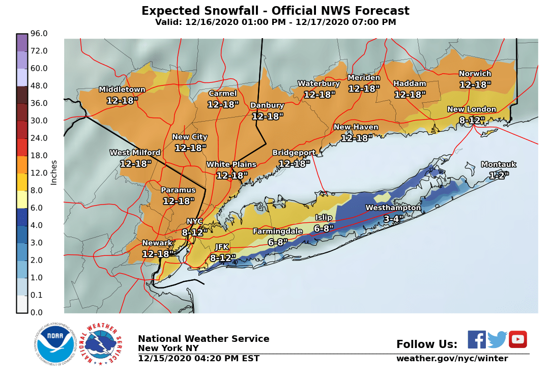
Below I have the NWS snowmap (the 4:00 -- I will note it is after 9:00 and they have not updated it which they would usually do at around 8:00) which shows their more aggressive forecast of 12 - 18"
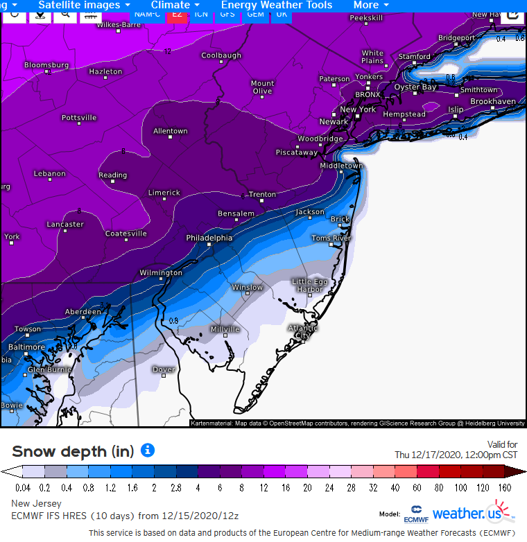
I have also included a snowmap from the EURO. Please note that snowmaps taken directly from models are NOT forecasts, they are mechanical data outputs. I am including this one to show how sharply the snow cuts off, and to note that should this line move (and it almost certainly will) that cut off could make a huge different in snow totals. On this particular map, the difference between 6" and 16" is 15 miles.
max_weisenfeld said:
WxNut2.0 said:
I am thoroughly shocked at the moment that the NWS is sticking with 12-16. But they know better than me and I’ll happily defer to them.
What do you make of the difference right now between the NAM and the Globals? Why would the NAM be the outlier?
This is an interesting question -- it was pointed out earlier that the NAM was doing a better job initializing the downstream ridge ahead of the trough that will help spin up the surface cyclone. Why that is is a different question altogether and one that's a little tough to discern without a dynamical sensitivity analysis.
One thing to note on this evenings runs of the NAM and some of the high-res CAMs: its further south. We needed a southward shift/end to the northward trend and we may have gotten it. The GFS and EC will be very interesting to watch, given the fact that the NAM seems to be what's leading the trends on this event. I'll be very curious to see if they follow suit or continue to trend north. This is an excruciatingly annoying storm to forecast.
Edited to add: the NAM12 brings a hellacious frontogenetic band over our area tomorrow that would pump up accumulations. Something to watch.
max_weisenfeld said:
I have also included a snowmap from the EURO. Please note that snowmaps taken directly from models are NOT forecasts, they are mechanical data outputs. I am including this one to show how sharply the snow cuts off, and to note that should this line move (and it almost certainly will) that cut off could make a huge different in snow totals. On this particular map, the difference between 6" and 16" is 15 miles.
Something to note with that Euro snow map: it may include sleet.
Wed morning update
12/16/20
Last forecast. After this we watch the snow fall.
The forecast is still on track for a major winter storm today and tonight, with minor adjustments to timing and a caveat about the back end.
In the MAPSO area, we expect 8 - 16" of snow (the NWS is still posting 12 - 18").
Snow could begin as early as noon but should not become heavy until around 6pm. Heaviest snow from 6 to midnight, could see accumulations of over an inch an hour for three hours or more. Snow eases some after midnight but could continue through the morning Thursday.
Caveats: some of the models are showing either a backend dry slot or some backend sleet mixing in. This signal has been persistent enough that I continue to hedge the bottom end. Either way I still do not expect ice accumulation as the snowpack will absorb any sleet that falls. On the other hand, some of the short range models are hinting at major snow bands forming that could add a couple of inches.
There is a Winter Storm Warning in effect from the NWS from 2:00 this afternoon until tomorrow at 1:00.
I miss snow & snow discussions. Sounds like you’ve got a fun one coming!

With all the different types of precipitation forecasted I’m thinking of just waiting until the storm has passed before I start shoveling.


Jaytee said:
With all the different types of precipitation forecasted I’m thinking of just waiting until the storm has passed before I start shoveling.
Since it looks to be heavy snow, I’m planning on shoveling every 2 inches or so.
metaphysician said:
Jaytee said:
With all the different types of precipitation forecasted I’m thinking of just waiting until the storm has passed before I start shoveling.
Since it looks to be heavy snow, I’m planning on shoveling every 2 inches or so.
The eternal debate ... shovel soon, shovel later, shovel every hour???

My impression of mid-storm shoveling is that it's largely inefficient. Your work just seems to fill in. At the end of the storm, you don't have X inches less depth from having shoveled X inches mid-storm.

Employment Wanted
Latest Jobs
Employment Wanted
-
Our amazing driving nanny is available for work.
Apr 28, 2024 at 8:05am
-
(No Fees) Hire A Baby Nurse Here for Your New Borns! (732)-737-7165
Apr 27, 2024 at 1:46am
-
(NO FEES) Hire A Fresh Energetic Nanny/ Housekeeper Here ! (732)-737-7165
Apr 27, 2024 at 1:46am
-
(NO Fees) Hire Housekeepers Here! ( 732)-737-7165
Apr 27, 2024 at 1:46am
-
(No Fees) Hire Home Health Aides Here! (732)-737-7165
Apr 27, 2024 at 1:46am
-
Summer Private Speech Therapist
Apr 26, 2024 at 9:12pm
-
Apr 26, 2024 at 1:58pm
-
(Classic Painting and Materials) Fair Prices. Spring and Summer Specials
Apr 25, 2024 at 5:14pm
Help Wanted
-
Part Time help for special needs young adult
Apr 27, 2024 at 4:43pm
-
Apr 25, 2024 at 6:15pm
Lessons/Instruction

Featured Events
-
Stephen Whitty Presents - Hometown Movie Stars: The Celebrated Actors Of CHS
May 6, 2024 at 7:00pm


Advertisement


Perhaps one of the more astute assessments from those of us not Wx-ucated. ;-)