Wind Chill Advisory Thurs - Sat, Jan 4 - 6 (Winter Storm Warning CANCELlED)

I'm in Long Branch, NJ now and 1010 WINS said Monmouth County is going to get it much worse than NYC or areas west.


Dr. Peter Venkman: Human sacrifice, dogs and cats living together... mass hysteria

Updated model runs are holding, with only slight variations in track and intensity. So still 3 - 5" and windy tomorrow, but if you want to place a bet on the over/under, take over by an inch or two.
We are soon moving into a real-time monitoring situation, where watching the radar and looking out the window are about the most accurate readings. I'll update in the morning from the models, but by then it will be mostly trying to predict where the heavier bands of snowfall will set up.

I wonder if Millburn will change their minds tonight?
wendyn said:
Millburn schools 2 hr delayed opening.


So far I'm very disappointed with this bomb cyclone, bombed is more fitting. Nary a flake in sight. I give it 1 out of 5 stars, wouldn't recommend.


Not seeing any accumulation yet either (I am slightly south and west of you). Heaviest snow is forecast for between 8 am and 2 pm so we shall see.
It's definitely a pretty slow Act 1.
spontaneous said:
So far I'm very disappointed with this bomb cyclone, bombed is more fitting. Nary a flake in sight. I give it 1 out of 5 stars, wouldn't recommend.
Winter Storm Warning
URGENT - WINTER WEATHER MESSAGE
National Weather Service New York NY
401 AM EST Thu Jan 4 2018
NJZ004-103>105-107-NYZ068>070-050600-
/O.UPG.KOKX.WW.Y.0001.000000T0000Z-180105T0600Z/
/O.EXA.KOKX.WS.W.0001.000000T0000Z-180105T0600Z/
Eastern Passaic-Western Bergen-Eastern Bergen-Western Essex-
Western Union-Putnam-Rockland-Northern Westchester-
401 AM EST Thu Jan 4 2018
...WINTER STORM WARNING IN EFFECT UNTIL 1 AM EST FRIDAY...
* WHAT...Heavy snow and blowing snow expected. Plan on difficult
travel conditions, including during the morning commute.
Snowfall rates of up to 1 inch per hour are possible this
morning into early afternoon. Total snow accumulations of 4 to 8
inches are expected.
* WHERE...Portions of northeast New Jersey and southeast New
York.
* WHEN...Until 1 AM EST Friday.
* ADDITIONAL DETAILS...Be prepared for significant reductions in
visibility at times. Wind gusts as high as 45 mph will causing
local areas of blowing and drifting snow, and bring down a few
tree limbs and powerlines.
PRECAUTIONARY/PREPAREDNESS ACTIONS...
A Winter Storm Warning for snow and blowing snow means severe
winter weather conditions are occurring. If you must travel, keep
an extra flashlight, food and water in your vehicle in case of an
emergency. The latest road conditions for the state you are
calling from can be obtained by calling 5 1 1.
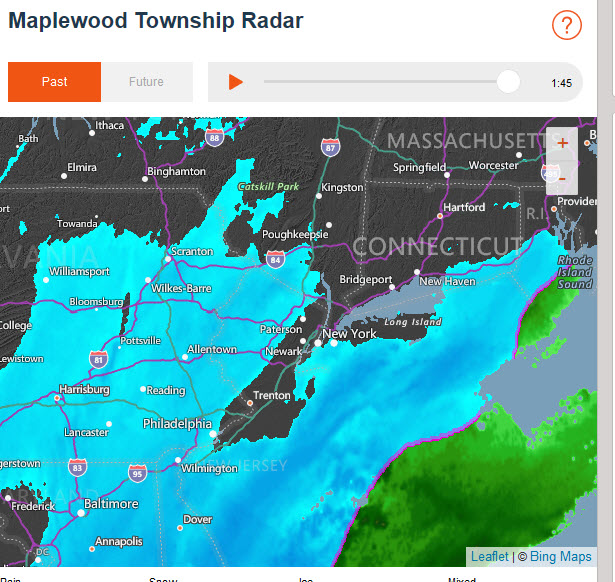
As the atmosphere has saturated, the virga has ended and snow is now reaching the ground.
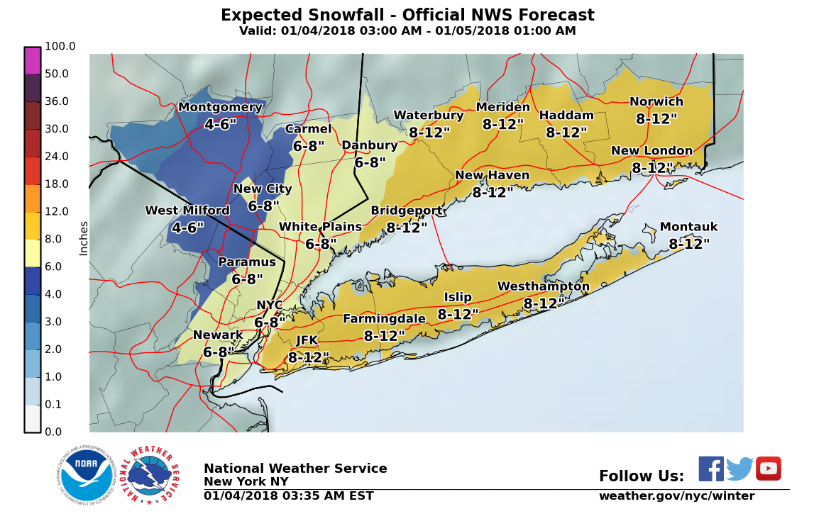
The latest observations support snow formation. What that means is that, although we are still getting the same half inch of water thet has been the forecast for the last 18 hours, it will yield lighter, and therefore deeper, snow. With the top end of the yield now over 6", and the winds arriving a bit earlier than forecast, the NWS has extended the WINTER STORM WARNING west to include our area.

thoughts about getting in and out of the city for work today? I am a bit concerned about the snow and winds knocking out NJT service, which is already sketchy on a normal day....Don't want to spend the night in Penn Station!!!!


Just took dog to the Reservation. Ir's quite nasty out. Cancelled my own plans to go to NYC.

6:14 AM Train from Morristown and all was quiet--just a few very small snowflakes.
7:14 AM arrived in NY Penn. Blowing and an inch and a half to two inches on the ground.
The City is going to get hit a lot harder than MaSO and Morristown on this one it seems. I think it is a great day to work from home if you can.
About 1/2 of the offices in the Midtown building I manage closed as of last night, and I expect very little foot traffic today. I have to come in to take care of the properties I manage, but for anyone who does not need to come in you should stay home and enjoy the day.

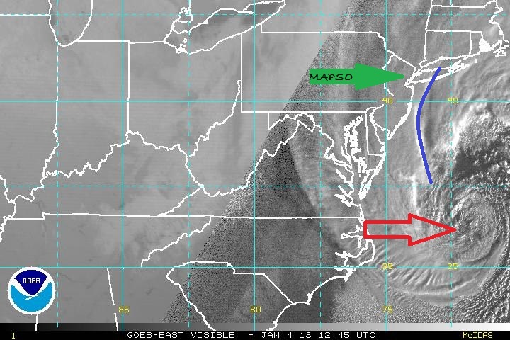
After spending some quality time with the observations and models, and having some coffee, here is how I think this will play out.
The storm is bombing out as advertised. It is developing an eye-like circulation off the North Carolina coast (red arrow on map) that will move northeast this morning, possibly clipping the east end of Long Island before crushing Mass with over a foot of snow. Although the heaviest banding is west of the center (towards land) it is still well offshore (blue line on map).
As the storm moves past us, it is likely now to maintain the forecast track from yesterday. There is good model consensus that the heaviest snow here will be from now through the early afternoon, or perhaps as late as five or so. The winds will be steady 25 - 30 with gusts up to 35 or even close to 40 mph, with highest winds this evening and again during the day tomorrow. Blowing and drifting snow will be an issue for the next 36 - 48 hours, well after snowfall ends.
The storm is moving quickly, and there is no reason to expect it to stall. That and the high winds* will suppress snow depth a bit. QPF (water falling from sky) is still projected to be about 1/2", but with yields only about 10 - 15 to 1, snow depth is likely to still only be 5 - 6" but drifting will make depths variable throughout the area.
~~~~~~~~~~~~~~~~~~~~~~~~~
*high winds break the snowflakes, allowing them to pack tighter and lowering snow depth.


Getting to Summit was a breeze. Easier than usual since no one was on the road.

The wind is playing havoc with the recycling bins out today in SO. We have drifts of newspapers shooting down the street at 20mph. I hope the trucks will come around but I wouldn’t be surprised if they don’t.
We missed our garbage pick up last Monday (Christmas) and again this Monday (New Years) so that is overflowing as well.

Going to work for a couple of hours. If anyone needs a 4th for a bridge game this afternoon, let me know.

GoSlugs said:
The wind is playing havoc with the recycling bins out today in SO. We have drifts of newspapers shooting down the street at 20mph. I hope the trucks will come around but I wouldn’t be surprised if they don’t.
We missed our garbage pick up last Monday (Christmas) and again this Monday (New Years) so that is overflowing as well.
Garbage and recycling were both picked up on the Tuesday following each holiday. At least in Maplewood, they did.
mantram said:
GoSlugs said:
The wind is playing havoc with the recycling bins out today in SO. We have drifts of newspapers shooting down the street at 20mph. I hope the trucks will come around but I wouldn’t be surprised if they don’t.
We missed our garbage pick up last Monday (Christmas) and again this Monday (New Years) so that is overflowing as well.
Garbage and recycling were both picked up on the Tuesday following each holiday. At least in Maplewood, they did.
Yeah, but SO has a completely different system.
From the South Orange Village Website:
Recycling Collection Has Been Suspended for Thursday, January 4th
Giordano Recycling has suspended all further pickups for Thursday, January 4, 2018. Please take the Toters recycling containers in as soon as possible to avoid the wind blowing recycling throughout the neighborhood.
All remaining resident's recycling will be collected on Monday, January 8th.
Please call Giordano for any updates with regards to the collection at 800-216-2250 ext. 2
GoSlugs said:
The wind is playing havoc with the recycling bins out today in SO. We have drifts of newspapers shooting down the street at 20mph. I hope the trucks will come around but I wouldn’t be surprised if they don’t.
We missed our garbage pick up last Monday (Christmas) and again this Monday (New Years) so that is overflowing as well.

Featured Events
-
Stephen Whitty Presents - Hometown Movie Stars: The Celebrated Actors Of CHS
May 6, 2024 at 7:00pm


Employment Wanted
Latest Jobs
Employment Wanted
-
(No Fees) Hire A Baby Nurse Here for Your New Borns! (732)-737-7165
Apr 27, 2024 at 1:46am
-
(NO FEES) Hire A Fresh Energetic Nanny/ Housekeeper Here ! (732)-737-7165
Apr 27, 2024 at 1:46am
-
(NO Fees) Hire Housekeepers Here! ( 732)-737-7165
Apr 27, 2024 at 1:46am
-
(No Fees) Hire Home Health Aides Here! (732)-737-7165
Apr 27, 2024 at 1:46am
-
Summer Private Speech Therapist
Apr 26, 2024 at 9:12pm
-
Apr 26, 2024 at 1:58pm
-
(Classic Painting and Materials) Fair Prices. Spring and Summer Specials
Apr 25, 2024 at 5:14pm
Help Wanted
-
Part Time help for special needs young adult
Apr 27, 2024 at 4:43pm
-
Apr 25, 2024 at 6:15pm
-
PF504 FT Companion/FA for 16 Year Old (ASAP Start)
Apr 25, 2024 at 4:05pm
Lessons/Instruction

Advertisement


dickf3