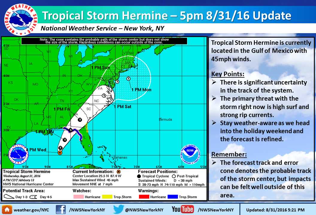
Tropical Storm Warning ENDED for the Jersey Shore and Eastern Essex County: Tropical Storm Hermine


I keep wanting it to be Hermione...
soda said:
Looks like lotsa rain & wind coming this way...
Just in time for Labor Day weekend?


Usually as a TS or TC travels over land it becomes disorganized and weakens. I'm surprised that the NWS models have it staying as a TS for so long over land. It'll be interesting to see how this storm develops after it makes landfall and move north over land.

I agree with Max. Nothing like a tropical storm to help refill the reservoirs.

boo! Rainy Labor Day weekend! We could have filled the reservoirs mid-week!
max_weisenfeld said:
We really need the rain.
Hopefully the recent lack of rain will moderate the effects of heavy rainfall from Hermine... I was sort of traumatized by Irene's impacts in 2011, but recall that the month leading up to the storm was one of the wettest on record in New Jersey.
This storm is no Irene, at least not for us. Irene was at hurricane strength when it made landfall here. To Komarovsky's point, this system will be much weaker. A lot will depend on whether it runs up the coast on shore or off. The models are not clearly forecasting the track yet.

Please get it through and outta here by Sunday night!
Yes, we need the rain, but I have US Open tix for Monday!

Looks to me like since last night, the NHC has adjusted the forecasted track and now they have it moving further offshore after it hits the North Carolina coast. We're still within the cone, but on the western edge, and now the timeline for local impacts seems to have been pushed back a little.
http://www.nhc.noaa.gov/refresh/graphics_at4+shtml/093138.shtml?5-daynl#contents
I'm kind of looking forward to a rainy day, although I feel bad for those with outdoor plans...
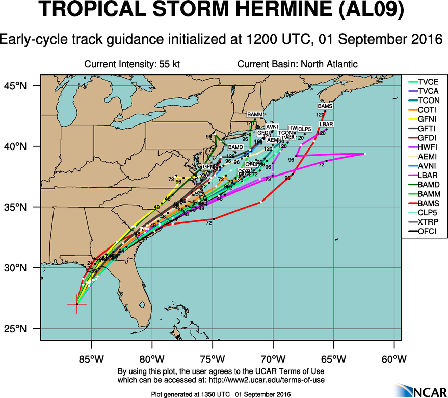
This morning it is farther east, but it is swinging rather widely each forecast run so i would not try to put a pin in it yet.
Just to give you an idea what they are working with, here is just one plot of this morning's model runs. There are several others available.
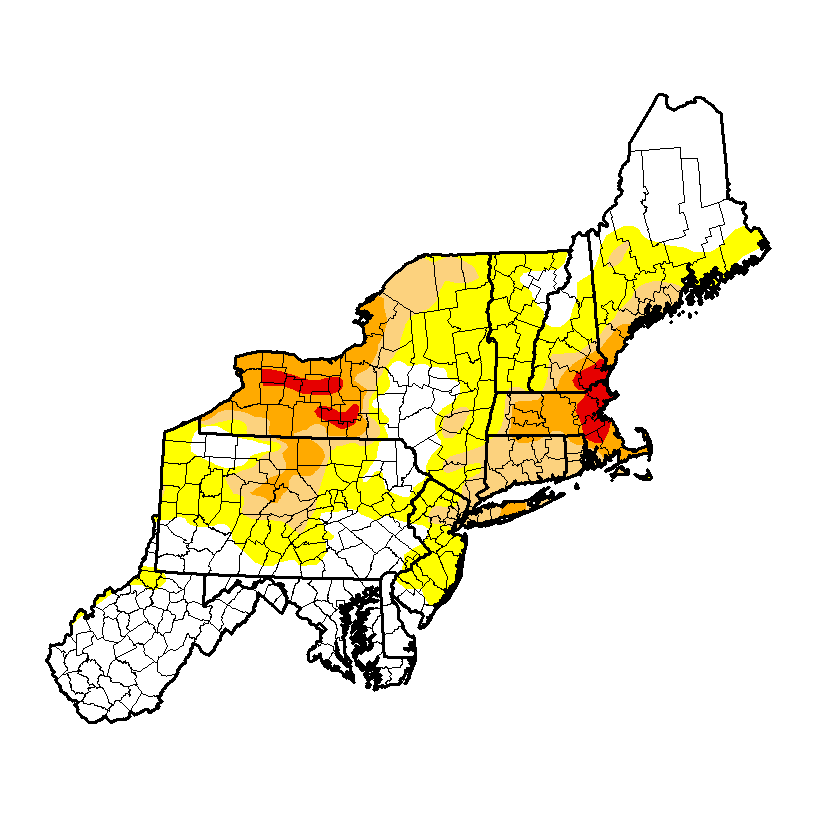
Here is this week's updated drought monitor. Our area remains at stage 1, moderate drought, while stage 0 ("abnormally dry") expands over the rest of New Jersey now. There are areas of stage 2, severe drought, now covering most of Massachusetts, western New York, and Suffolk County on Long Island. Stage 4, extreme drought, is affecting the Boston area and around the Finger Lakes.
Today's rain will have zero effect on these drought conditions. We need two weeks and 6 - 8 inches of rain to get back to normal.

am I correct in recalling that including Irene, our area received roughly 20" of rain over 2 weeks that month?
bluepool said:
max_weisenfeld said:
We really need the rain.
Hopefully the recent lack of rain will moderate the effects of heavy rainfall from Hermine... I was sort of traumatized by Irene's impacts in 2011, but recall that the month leading up to the storm was one of the wettest on record in New Jersey.

ml1 said:
am I correct in recalling that including Irene, our area received roughly 20" of rain over 2 weeks that month?
bluepool said:
max_weisenfeld said:
We really need the rain.
Hopefully the recent lack of rain will moderate the effects of heavy rainfall from Hermine... I was sort of traumatized by Irene's impacts in 2011, but recall that the month leading up to the storm was one of the wettest on record in New Jersey.
August 2011 was one of the wettest on record for New Jersey, especially for the counties effected by Irene. I was not taking official readings yet, but for the state as a whole, the average was 16.64", and in Essex County the monthly total was 17.39" at Cedar Grove and 18.79" at Newark.
More details here: http://climate.rutgers.edu/stateclim/?%20target=aug11
j_r said:
"HER-mah-nee"? "HER-mine"?
Not HermiOne. I am saying HER-mine, but am not an authority on storm pronunciation.

max_weisenfeld said:
j_r said:
"HER-mah-nee"? "HER-mine"?
Not HermiOne. I am saying HER-mine, but am not an authority on storm pronunciation.
My thought is the pronunciation is like "pristine" so "Hermine".
The pronouncer I linked to makes it sound like French-accented "ermine." (AIR-hhhmeen)

I'm out of the country right now and reading this on a phone. Where do we expect Hermine to be by Saturday afternoon?

You say Ih-RIH-nay, I say Eye-REEN
You say Her-MY-nee, I say Er-MEEN
Ih-RIH-nay, Eye-REEN; Her-MY-nee, Er-MEEN
Let's call the whole thing Trough.
Hermine is now a hurricane.
This model cycle the forecast track has remained to the east, just offshore from our area. However, heavy rain and high (while not gale-force) winds are still very much a possibility.
I am becoming concerned that the storm may stall, and even strengthen a bit, Sunday - Tuesday in the waters off NJ. This could lead to several days of heavy rain.
This was included in the latest National Hurricane Center Advisory:
1. As landfall nears, it is important to not focus on the exact
forecast track. Hermine is an extremely asymmetric storm, with a
large extent of dangerous winds, life-threatening storm surge, and
flooding rains well to the east and southeast of the path of the
center.
2. Hermine is expected to become a post-tropical cyclone while still
producing hazardous winds and storm surge over land. NWS policy
allows NHC to write advisories on and issue tropical storm
watches and warnings for post-tropical cyclones, when the system
continues to pose a significant threat to life and property.
NHC and the NWS Eastern Region have decided that this option will be
invoked for Hermine. After Hermine becomes a post-tropical cyclone,
NHC will continue to issue its full suite of advisory and warning
products for as long as the system remains a significant threat to
land.
Note that at this time the Tropical Storm Watch is for the shore counties only. The NWS in Mt. holly (Philadelphia Office) has also issued this statement, covering areas south and west of us. This statement does NOT cover our immediate area at this time, but there is good information in here, and something similar should be coming from Upton (NWS New York) later, bearing in mind that the storm will hit the southern part of the Mt. Holly coverage area 24 - 36 hours before us.
Hurricane Local Statement
TROPICAL STORM HERMINE LOCAL STATEMENT SPECIAL ADVISORY NUMBER 17
DEZ001>004-MDZ008-012-015-019-020-NJZ001-007>010-012>027-PAZ054-055-060>062-070-071-101>106-020500-
TROPICAL STORM HERMINE LOCAL STATEMENT SPECIAL ADVISORY NUMBER 17
NATIONAL WEATHER SERVICE MOUNT HOLLY NJ AL092016
449 PM EDT THU SEP 1 2016
THIS PRODUCT COVERS NEW JERSEY...DELAWARE...SOUTHEASTERN PENNSYLVANIA AND NORTHEAST MARYLAND.
**HERMINE TO AFFECT THE REGION THIS WEEKEND**
NEW INFORMATION
---------------
* CHANGES TO WATCHES AND WARNINGS:
- A TROPICAL STORM WATCH HAS BEEN ISSUED FOR INLAND
SUSSEX...DELAWARE BEACHES...WESTERN MONMOUTH...EASTERN
MONMOUTH...OCEAN...ATLANTIC...CAPE MAY...ATLANTIC COASTAL CAPE
MAY...COASTAL ATLANTIC...COASTAL OCEAN AND SOUTHEASTERN
BURLINGTON
* CURRENT WATCHES AND WARNINGS:
- A TROPICAL STORM WATCH IS IN EFFECT FOR INLAND
SUSSEX...DELAWARE BEACHES...WESTERN MONMOUTH...EASTERN
MONMOUTH...OCEAN...ATLANTIC...CAPE MAY...ATLANTIC COASTAL CAPE
MAY...COASTAL ATLANTIC...COASTAL OCEAN AND SOUTHEASTERN
BURLINGTON
* STORM INFORMATION:
- ABOUT 1020 MILES SOUTHWEST OF ATLANTIC CITY NJ OR ABOUT 970
MILES SOUTHWEST OF DOVER DE
- 27.8N 85.6W
- STORM INTENSITY 70 MPH
- MOVEMENT NORTH-NORTHEAST OR 30 DEGREES AT 14 MPH
SITUATION OVERVIEW
------------------
HERMINE WILL BE AFFECTING COASTAL AREAS OF DELAWARE AND NEW JERSEY
THROUGH THE HOLIDAY WEEKEND. HURRICANE HERMINE IS FORECAST TO MAKE
LANDFALL TONIGHT IN NORTHERN FLORIDA. THE STORM IS THEN EXPECTED
TO MOVE NORTHEASTWARD, MOVING INTO THE ATLANTIC BY SATURDAY AND
STAYING OFF THE THE COAST THROUGH THE WEEKEND.
POTENTIAL IMPACTS
-----------------
* FLOODING RAIN: PREPARE FOR LOCALLY HAZARDOUS RAINFALL FLOODING
HAVING POSSIBLE LIMITED IMPACTS ACROSS COASTAL LOCATIONS AND THE
COASTAL PLAINS. POTENTIAL IMPACTS INCLUDE: - LOCALIZED RAINFALL
FLOODING MAY PROMPT A FEW EVACUATIONS. - RIVERS AND TRIBUTARIES
MAY QUICKLY RISE WITH SWIFTER CURRENTS. SMALL STREAMS, CREEKS,
CANALS, AND DITCHES MAY BECOME SWOLLEN AND OVERFLOW IN SPOTS. -
FLOOD WATERS CAN ENTER A FEW STRUCTURES, ESPECIALLY IN
VULNERABLE SPOTS. RAPID PONDING OF WATER MAY OCCUR AT
UNDERPASSES, LOW-LYING SPOTS, AND POOR DRAINAGE AREAS. SEVERAL
STORM DRAINS AND RETENTION PONDS BECOME NEAR-FULL AND BEGIN TO
OVERFLOW. SOME BRIEF ROAD AND BRIDGE CLOSURES ARE POSSIBLE.
ELSEWHERE ACROSS NEW JERSEY...DELAWARE...SOUTHEASTERN PENNSYLVANIA
AND NORTHEAST MARYLAND., LITTLE TO NO IMPACT IS ANTICIPATED.
* WIND:
PREPARE FOR HAZARDOUS WIND HAVING POSSIBLE LIMITED IMPACTS ACROSS NEW
JERSEY...DELAWARE...SOUTHEASTERN PENNSYLVANIA AND NORTHEAST
MARYLAND.. POTENTIAL IMPACTS INCLUDE:
- DAMAGE TO PORCHES, AWNINGS, CARPORTS, SHEDS, AND UNANCHORED
MOBILE HOMES IS POSSIBLE. UNSECURED LIGHTWEIGHT OBJECTS COULD
BE BLOWN AROUND.
- MANY LARGE TREE LIMBS MAY BE BROKEN OFF. A FEW TREES COULD BE
SNAPPED OR UPROOTED. SOME FENCES AND ROADWAY SIGNS MAY BE BLOWN
OVER.
- A FEW ROADS COULD BE IMPASSABLE FROM DEBRIS. HAZARDOUS DRIVING
CONDITIONS ARE POSSIBLE ON BRIDGES AND OTHER ELEVATED ROADWAYS.
- SCATTERED POWER AND COMMUNICATIONS OUTAGES ARE POSSIBLE.
* SURGE: LITTLE TO NO IMPACTS ARE ANTICIPATED AT THIS TIME ACROSS
NEW JERSEY...DELAWARE...SOUTHEASTERN PENNSYLVANIA AND NORTHEAST
MARYLAND. HOWEVER...TIDAL FLOODING IS POSSIBLE.
PRECAUTIONARY/PREPAREDNESS ACTIONS
----------------------------------
* EVACUATIONS:IF YOU ARE EXCEPTIONALLY VULNERABLE TO WIND OR
WATER HAZARDS FROM TROPICAL SYSTEMS, CONSIDER VOLUNTARY
EVACUATION, ESPECIALLY IF BEING OFFICIALLY RECOMMENDED. RELOCATE
TO A PREDETERMINED SHELTER OR SAFE DESTINATION.
* OTHER PREPAREDNESS INFORMATION: NOW IS THE TIME TO CHECK YOUR
EMERGENCY PLAN AND TAKE NECESSARY ACTIONS TO SECURE YOUR HOME OR
BUSINESS. DELIBERATE EFFORTS SHOULD BE UNDERWAY TO PROTECT LIFE
AND PROPERTY. ENSURE THAT YOUR EMERGENCY SUPPLIES KIT IS STOCKED
AND READY.
VISITORS TO THE AREA SHOULD BECOME FAMILIAR WITH NEARBY
SURROUNDINGS. IF YOU ARE A VISITOR, KNOW THE NAME OF THE COUNTY
IN WHICH YOU ARE LOCATED AND WHERE IT IS RELATIVE TO CURRENT
WATCHES AND WARNINGS. IF STAYING AT A HOTEL, ASK THE MANAGEMENT
STAFF ABOUT THEIR ON SITE DISASTER PLAN. LISTEN FOR EVACUATION
ORDERS, ESPECIALLY PERTAINING TO AREA VISITORS.
CLOSELY MONITOR NOAA WEATHER RADIO OR OTHER LOCAL NEWS OUTLETS
FOR OFFICIAL STORM INFORMATION. LISTEN FOR POSSIBLE CHANGES TO
THE FORECAST.
* ADDITIONAL SOURCES OF INFORMATION:
- FOR INFORMATION ON APPROPRIATE PREPARATIONS SEE READY.GOV
- FOR INFORMATION ON CREATING AN EMERGENCY PLAN SEE GETAGAMEPLAN.ORG
- FOR ADDITIONAL DISASTER PREPAREDNESS INFORMATION SEE REDCROSS.ORG
This morning the models have held pretty steady again with the forecast for our area.
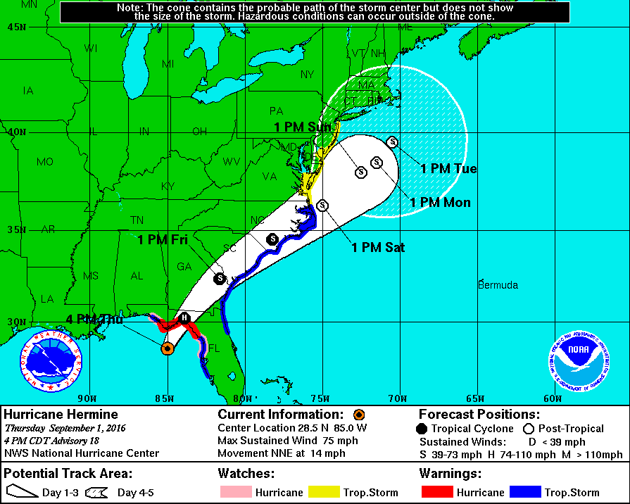
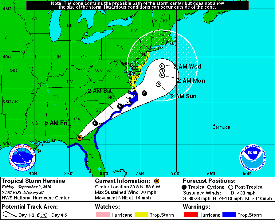
Hermine, now downgraded back to a tropical storm, made landfall on the Florida panhandle about midnight last night. The track then runs inland until Saturday morning, crossing Ga and SC and out to sea near the NC coast. It should then slow, moving northeast and arriving off the Jersey Shore Sunday. The entire Jersey Shore is under a tropical storm watch.
There is at this time a 50/50 chance of the storm impacting our area.
Effects would include moderate to potentially heavy rain and strong, gusty winds.
The storm is likely to stall south of Long Island through midweek.
From the NWS:
Hazardous Weather Outlook
HAZARDOUS WEATHER OUTLOOK
NATIONAL WEATHER SERVICE NEW YORK NY
445 AM EDT FRI SEP 2 2016
445 AM EDT FRI SEP 2 2016
THIS HAZARDOUS WEATHER OUTLOOK IS FOR SOUTHERN
CONNECTICUT...NORTHEAST NEW JERSEY AND SOUTHEAST NEW YORK.
.DAY ONE...TODAY AND TONIGHT.
HAZARDOUS WEATHER IS NOT EXPECTED AT THIS TIME.
.DAYS TWO THROUGH SEVEN...SATURDAY THROUGH THURSDAY.
STARTING LATE SATURDAY...TROPICAL CYCLONE HERMINE COULD IMPACT
THE AREA WITH EFFECTS LASTING THROUGH THE LABOR DAY HOLIDAY
WEEKEND INTO TUESDAY. MODERATE TO MAJOR COASTAL FLOODING
IMPACTS...AS WELL AS HEAVY RAIN AND STRONG WINDS...ARE POSSIBLE
DEPENDING ON THE EXACT TRACK AND STRENGTH OF THE SYSTEM. AT THE
LEAST...A HIGH RISK FOR RIP CURRENTS AS WELL AS BEACH EROSION WILL
EXIST THROUGH THE WEEKEND AND INTO EARLY NEXT WEEK.
.SPOTTER INFORMATION STATEMENT...
SPOTTER ACTIVATION MAY BE NEEDED.
&&
THIS HAZARDOUS WEATHER OUTLOOK PROVIDES A SUMMARY OF POTENTIAL
WIDESPREAD HAZARDOUS WEATHER EVENTS THAT MAY REACH NWS WARNING
CRITERIA. MOST LONG FUSED NWS WATCHES...WARNINGS AND ADVISORIES IN
EFFECT ARE HIGHLIGHTED.
PLEASE REFER TO THE LATEST NWS FORECASTS FOR WEATHER NOT MEETING NWS
WARNING CRITERIA.

For Sale


Sponsored Business


Promote your business here - Businesses get highlighted throughout the site and you can add a deal.

Advertisement


Per the NWS:
"Tropical Depression 9 is now Tropical Storm Hermine. While the forecast track has shifted west, there is still significant uncertainty in the track of this system. Stay tuned to the National Hurricane Center for the latest
updates. hurricanes.gov"