The Idiot's Guide to South Mountain


Actually, we'd like to visit the waterfall - haven't ever done so. When I checked the South Mountain Res. site, it talks about fording a couple of streams - can you give me any info about how wide/slippery are the crossings? I'll pass on options (e) through (g), though!

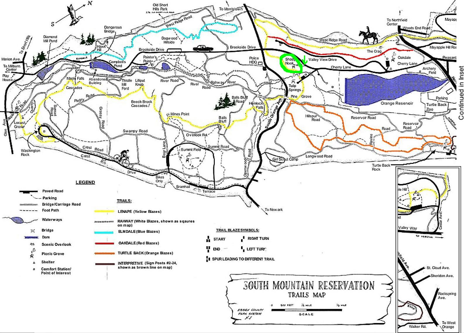
If you go to the Maplewood Library (or probably other places, but I'm not sure where), you can purchase a trail map for about $5, I think. If you can't wait until the library opens, PM me your email address and I will email you the best scanned copy I can manage of mine. It's copyrighted, so I am not going to post it here, but I think you will find it worth the $5 to get the nice laminated copy. And it's supporting a great cause, the South Mountain Conservancy. Their website at http://www.somocon.org/ has LOTS of info on hiking and other activities in the reservation.
There is a trailhead right across Glen Avenue from the Millburn First Aid Squad. There are also a number of trails that go off Crest Drive up on top. (Take South Orange Avenue past the tall condo buildings and then turn left at the Reservation sign.) That's also where the dog park is and where there is a gat across a road that is closed to motor vehicles, but great for biking, walking, skating, dog walking, etc. (We taught our kids to ride bike up there because it is fairly flat.) I'm not sure of the status of the trails connected to the bridge(s) over South Orange avenue at this point, given the construction there. There are also trails that come out on Brookside Drive (above the Papermill Playhouse) and no doubt many other places. If you go north of South Orange Avenue, you get to the more developed section where they now have paddle boats and a paved walkway around the reservoir there ... not far from the zoo, arena and McCloone's restaurant. And I believe that there are more trails in the woods behind that area as well.
Good luck and happy exploring!
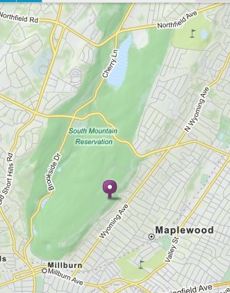
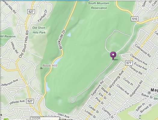
PS - The below two pictures - one covering the total area of the reservation and one of the southern half, showing some of the roads and entrances I mentioned, are from Mapquest. But they don't show trails.

cody said:
Actually, we'd like to visit the waterfall - haven't ever done so. When I checked the South Mountain Res. site, it talks about fording a couple of streams - can you give me any info about how wide/slippery are the crossings? I'll pass on options (e) through (g), though!
The last time I went to the waterfall, I don't recall anything memorable about fording streams. Maybe stepping from one side of a stream to a rock to the other side or similar, but I know I didn't get my feet wet. Of course, that could vary a lot depending on recent weather conditions and I haven't been there in a few months.
You can also get to the waterfall from above (somewhere off Crest Drive, but I'm not exactly sure where ... I always have started near the bottom and then ended up on top and didn't play close attention to where I came out.) I'm pretty sure there wasn't any stream fording in that top section.

Lenape Trail has a few "fords," sort of, but nothing too dramatic.

There's a South Mountain Conservancy meetup group too. Great way to get reminders for the guided hikes.
http://www.meetup.com/somocon/


Red_Barchetta said:
Well, I guess that depends on what you are looking to do. Can you narrow it down: a) go for a hike b) take a bike ride c) take your dog for a walk d) view the waterfall e) hunt deer f) engage in a sex act with a stranger g) hide a body
#winning

Drummerboy,
If you have never been to the reservation, you should start with the paved loop over by the dog run. It's a mile or so walk. I'd be glad to show you if you are not sure. I love going there. Once you master that, then you can try going father afield and hunting for the waterfall or other landmarks. Also, you can join the Sierra Club for about $25 and go on hikes with them (or just pay $5 bucks per hike). They have several throughout the year in the reservation.
The South Mountain conservancy also leads hikes and I don't recall a charge for those. They are written up from time to time in the News-Record and I assume announced on their website.

The paved road is a good option for getting your bearings, because there are a lot of places where you have a great view. Use the loop @nan mentions (park at the dog park and follow the mile-long loop road, which you can circle in your car first if you like). Or go through the gates to the no-cars road, for a two-mile out and back to a lookout over Millburn and Springfield. Or combine the two for a 5k!
If you'd rather hike on a trail, a good place to start is the parking lot across from the Millburn library. Just keep going uphill on one of several trails until you get to the top.
There is also a trail up from Warner Road up above Wyoming Avenue in Maplewood. I think it comes out right near the gate to the no-motor-vehicles section of the road near the dog park.

Red_Barchetta said:
Well, I guess that depends on what you are looking to do. Can you narrow it down: a) go for a hike b) take a bike ride c) take your dog for a walk d) view the waterfall e) hunt deer f) engage in a sex act with a stranger g) hide a body
Hi, could you provide more details on D and F, please? TIA
MOL_Rat said:
Red_Barchetta said:Hi, could you provide more details on D and F, please? TIA
Well, I guess that depends on what you are looking to do. Can you narrow it down: a) go for a hike b) take a bike ride c) take your dog for a walk d) view the waterfall e) hunt deer f) engage in a sex act with a stranger g) hide a body
F -- Ugh, I know too much about this from the years when I had a hyper dog and spent a LOT of time hiking in the res. Watch for cars parked backwards, especially in the evening. I also encountered some sort of religious display involving a pig's head. I can post a picture if anyone is interested.

sac said:
There is also a trail up from Warner Road up above Wyoming Avenue in Maplewood. I think it comes out right near the gate to the no-motor-vehicles section of the road near the dog park.
Yes, you can either go up Warner or Claremont Ave. lots of people drive up to the entrance at the top of Claremont and then walk up the steps. It's very steep. Once you get to the top, the paved loop will be to your left through a gate and the dog run and parking lot will be straight ahead. I like the paved loop--naturey and quiet but I can push a stroller and not get lost in the woods, which I am honestly nervous about if I go on a regular trail
Many thanks to the posters who gave me info on Hemlock Falls! We're looking forward to getting to them very soon.

Red_Barchetta said:
Well, I guess that depends on what you are looking to do. Can you narrow it down: a) go for a hike b) take a bike ride c) take your dog for a walk d) view the waterfall e) hunt deer f) engage in a sex act with a stranger g) hide a body
Hiking and the waterfalls sound like good places to start. Sex can come later.

As someone who does NOT want to have sex with strangers, but who DOES almost always back into parking spaces whenever possible ... should I not be doing that when I park up by the dog park to go running?
kthnry said:
MOL_Rat said:F -- Ugh, I know too much about this from the years when I had a hyper dog and spent a LOT of time hiking in the res. Watch for cars parked backwards, especially in the evening. I also encountered some sort of religious display involving a pig's head. I can post a picture if anyone is interested.
Red_Barchetta said:Hi, could you provide more details on D and F, please? TIA
Well, I guess that depends on what you are looking to do. Can you narrow it down: a) go for a hike b) take a bike ride c) take your dog for a walk d) view the waterfall e) hunt deer f) engage in a sex act with a stranger g) hide a body
There is more than one waterfall in the Res., although Hemlock Falls is obviously the closest to a road. And the only sex I ever saw going on was of the heterosexual variety. Hope that's not TMI.
chopin said:
There is more than one waterfall in the Res., although Hemlock Falls is obviously the closest to a road.
Have hiked extensively in the reservation, and no waterfall comes close to Hemlock Falls.
Try to visit after a big rain, and enjoy a picnic on the rocks at the top.
All I know is that is that other falls are shown on the official map. I seem to remember one called "Maple Falls," but I have not seen it personally.

Helpful hint: If you memorize the location of the major roads, you can use Google Maps on your phone to see where you are relative to the roads and monitor your progress back to your car. If I knew the first thing about app development, I would map the trails and sell an app.
kthnry said:
Helpful hint: If you memorize the location of the major roads, you can use Google Maps on your phone to see where you are relative to the roads and monitor your progress back to your car. If I knew the first thing about app development, I would map the trails and sell an app.
Yes!!
The Maple Falls do indeed cascade more than fall, and sometimes just trickle unless there has been recent rain. If you do the Lenape Trail, which is the hiking-est of the various paths, you'll cross it. It's one of those pseudo-fords, as in, it requires 1.25 of a normal step.

cody said:
Actually, we'd like to visit the waterfall - haven't ever done so. When I checked the South Mountain Res. site, it talks about fording a couple of streams - can you give me any info about how wide/slippery are the crossings? I'll pass on options (e) through (g), though!
So just to clarify... you'd like to Climb Every Mountain? Ford every stream?
SouthernBaron said:
The Maple Falls do indeed cascade more than fall, and sometimes just trickle unless there has been recent rain. If you do the Lenape Trail, which is the hiking-est of the various paths, you'll cross it. It's one of those pseudo-fords, as in, it requires 1.25 of a normal step.
@Jamie - thanks for the color coded map! Mine is black/white and does not show Maple Falls Cascades.
@SouthernBaron - I've hiked the Lenape Trail before and never noticed the Falls - so it must have been during a dry spell. Guess I'll have to go after a big rainfall.

Sponsored Business


Promote your business here - Businesses get highlighted throughout the site and you can add a deal.
For Sale


Advertisement


I'm embarrassed to say that after (very many) years of living in the area, I have never actually visited South Mountain Reservation. I've never hiked through it.
So where should I go?