Old Thread About Snow on Friday, March 10

Thanks Max.
I wonder if the school district will call a snow day since we've only used one.

Max,
Please revise this prediction (we are supposed to take a day trip to the NY Botanical Garden on Friday).
Thank you in advance.

F*cking awesome.  I have to take my kid to the doc up in Clifton on Friday morning to have his stitches removed. The doc is going away so Friday morning is the only day she is available (before Friday would be too soon). If I can't get him up there I was told to bring him back to the ER instead, which I really don't want to have to do since it'll likely mean waiting around for a few hours. I know it isn't anyone's fault and there's nothing that can be done about it, I'm just pissed in general.


@spontaneous - stitches are easy to remove (I've done so with permission from pediatrician). But maybe a diff doc?
doulamomma said:
@spontaneous - stitches are easy to remove (I've done so with permission from pediatrician). But maybe a diff doc?
I discussed it with my husband and if our pediatrician's office closes on Friday he will take our son to the ER himself since he works at the hospital and interacts with the ER staff daily. He assures me he will be able to get in and out quickly.

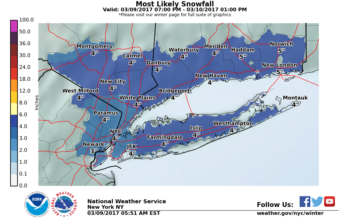
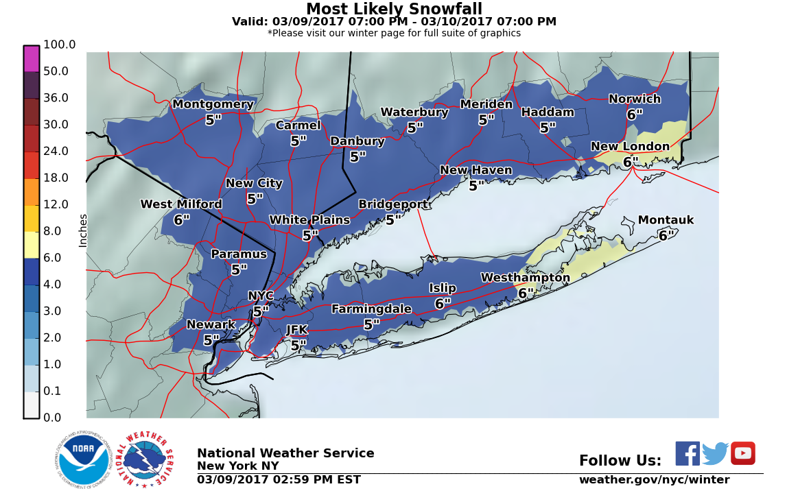
The models are in good agreement on a moderate snowfall of 3" to 5" across the area Friday morning.
Enjoy today, it should be lovely. Temps will drop rapidly overnight, especially once precipitation begins. Any rain will quickly change over, and there could be an inch or two by the morning commute. Snow will continue through the day, tapering off towards evening.
Conditions should exist for bands of heavier snow to pass through. Where and when those bands develop is hard to predict. Snow in one of these bands could get heavier, and totals could go a couple of inches higher than forecast. Bands will be isolated.
From the NWS:
URGENT - WINTER WEATHER MESSAGE
National Weather Service New York NY 327 AM EST Thu Mar 9 2017
...ACCUMULATING SNOW LATE TONIGHT INTO EARLY FRIDAY AFTERNOON... ...WINTER WEATHER ADVISORY IN EFFECT FROM 10 PM THIS EVENING TO 2 PM EST FRIDAY...
The National Weather Service in Upton has issued a Winter Weather Advisory for snow, which is in effect from 10 PM this evening to 2 PM EST Friday.
* Locations...New York City Metro, Northeast New Jersey, Long Island, Lower Hudson Valley, and Southern Connecticut.
* Hazard Types...Snow
* Accumulations...Snow accumulation of 3 to 5 inches.
* Timing...Late tonight into early Friday afternoon.
* Impacts...Hazardous/slippery travel due to snow accumulations.
* Temperatures...Around freezing.
* Visibilities...One half mile at times.
PRECAUTIONARY/PREPAREDNESS ACTIONS... A Winter Weather Advisory means that periods of snow...sleet...or freezing rain will cause travel difficulties. Be prepared for slippery roads and limited visibilities...and use caution while driving. &&
Current NWS snow map. I think the map lowballs us, but only by an inch or two.


Hey spontaneous -
Maybe go to an urgent care center instead of ER. I've been going to the new one on Northfield right by the intersection of Livingston Ave. It is Summit Medical Group. Never had to wait more than 5 - 10 minutes. I think they are equipped for that kind of thing...but call just in case.

doulamomma said:
@spontaneous - stitches are easy to remove (I've done so with permission from pediatrician). But maybe a diff doc?
Agree. I have done it too.

Is it too soon to ask about the possible nor'easter next Tuesday - Wednesday?
finnegan said:
Is it too soon to ask about the possible nor'easter next Tuesday - Wednesday?
Yes.
But since you asked, there is that potential, yes, but as you noted we are still too far out to reliably forecast it.
max_weisenfeld said:
Current NWS snow map. I think the map lowballs us, but only by an inch or two.
As I was saying...
At this time, we are still under an Advisory. If projected snow totals go up any more, though, we will be upgraded to a Watch or Warning. Eastern LI is under a Warning for this storm.

doulamomma said:
@spontaneous - stitches are easy to remove (I've done so with permission from pediatrician). But maybe a diff doc?
I have taken out stitches many times as well. It's super easy. I even have the tool for staples. Haha.
Life is weird in every way, lately. It's like spinning the wheel on the Price is Right!
mammabear said:
doulamomma said:
@spontaneous - stitches are easy to remove (I've done so with permission from pediatrician). But maybe a diff doc?
I have taken out stitches many times as well. It's super easy. I even have the tool for staples. Haha.
Badass! If we ever get staples I'm heading your way when it's time for removal!

Is it me, or is it weird that NOAA is already using Eastern Daylight Time?
ETA and imprecise time, too!

Just checked and it looks like NOAA is adjusting downward:
Tonight
Rain, mainly after 2am. Low around 34. North wind 5 to 8 mph. Chance of precipitation is 80%. New precipitation amounts between a tenth and quarter of an inch possible.
Friday
Rain and snow, becoming all snow after noon. High near 37. North wind 9 to 15 mph becoming northwest in the afternoon. Winds could gust as high as 29 mph. Chance of precipitation is 90%. New snow accumulation of 1 to 3 inches possible.
Latest issued at 9:24pm:
...WINTER WEATHER ADVISORY NOW IN EFFECT UNTIL 2 PM EST FRIDAY...
* Locations...New York City Metro, Northeast New Jersey, Nassau
and Western Suffolk Counties, Southern Westchester County, and
Southern Connecticut west of New London County.
* Hazard Types...Snow.
* Accumulations...Snow accumulation of 3 to 5 inches. <<<<<<
* Timing...Heaviest snow overnight into Friday morning.
* Impacts...Hazardous/slippery travel due to snow accumulations.
* Temperatures...In the low 30s.
* Visibilities...One quarter to one half mile at times.
PRECAUTIONARY/PREPAREDNESS ACTIONS...
A Winter Weather Advisory means that periods of snow...sleet...or
freezing rain will cause travel difficulties. Be prepared for
slippery roads and limited visibilities...and use caution while
driving.
http://www.weather.gov/images/okx/winter/SnowAmt10Prcntl.png
http://www.weather.gov/images/okx/winter/StormTotalSnowWeb1.png
http://www.weather.gov/images/okx/winter/SnowAmt90Prcntl.png
Deb, i think you may be picking up the wrong zip code in your app. Here is what they are saying for Western Essex County:
Tonight
A chance of rain before 2am, then snow, possibly mixed with rain. Patchy
fog after 2am. Low around 32. Wind chill values between 25 and 30.
North wind 6 to 8 mph. Chance of precipitation is 80%. Total nighttime
snow accumulation of around an inch possible.
Friday
Snow, mainly before 11am. Patchy fog before 2pm. High near 38. Wind chill
values between 25 and 30. North wind 7 to 15 mph becoming northwest in
the afternoon. Winds could gust as high as 26 mph. Chance of
precipitation is 90%. New snow accumulation of 3 to 5 inches possible.
That's 4" - 6" which is up an inch from the afternoon.
bets said:
Is it me, or is it weird that NOAA is already using Eastern Daylight Time?
ETA and imprecise time, too!
It's accurate on my computer. As for EDT, they must have changed the tag, but the time is still EST.
Interesting. The radar is showing rain over northwest NJ but nothing on the models and no reports. Must be the dreaded virga!*
* http://earthsky.org/earth/virga-is-rain-that-doesnt-reach-the-ground
max_weisenfeld said:
It's accurate on my computer. As for EDT, they must have changed the tag, but the time is still EST.
Between this and my pixle showing 82 degree temperatures in South Orange yesterday, I'm getting a little paranoid. Is my phone trying to tell me something?
Hopefully tomorrow it'll tell me it's a snow day
Snow is getting a late start but should be here shortly. NWS now back at 2" - 4"
Moderate but steady snow (once it gets started) with possibly a heavier band running from now until mid afternoon.


Employment Wanted
Latest Jobs
Employment Wanted
-
(Classic Painting and Materials) Fair Prices. Spring and Summer Specials
Apr 25, 2024 at 5:14pm
-
Apr 25, 2024 at 8:08am
-
Apr 24, 2024 at 1:13pm
-
****Laundry + Bedrooms Organization : closets,drawers,shelves
Apr 24, 2024 at 8:04am
Help Wanted
-
Apr 25, 2024 at 6:15pm
-
PF504 FT Companion/FA for 16 Year Old (ASAP Start)
Apr 25, 2024 at 4:05pm
-
Apr 25, 2024 at 12:24pm
-
Part-time long term Nanny for toddler boy in Basking Ridge
Apr 24, 2024 at 7:49pm
-
PF802 FT M-Th Nanny for 2 (ASAP Start)
Apr 24, 2024 at 1:21pm
-
Photo Booth Attendant- Great for high school senior, college student, profeessional
Apr 24, 2024 at 5:55am
Lessons/Instruction

Sponsored Business


Promote your business here - Businesses get highlighted throughout the site and you can add a deal.

Advertisement


Models are in decent agreement for a moderate snowfall overnight Thursday into Friday midday. Total accumulation in the 2 - 4" range.
Midday Friday precipitation could change over to rain briefly before ending as temps climb to 40°
Overnight Friday - Saturday there could be icy conditions as temps drop into the teens.