Severe Thunderstorm Watch this afternoon and evening, Monday July 18th

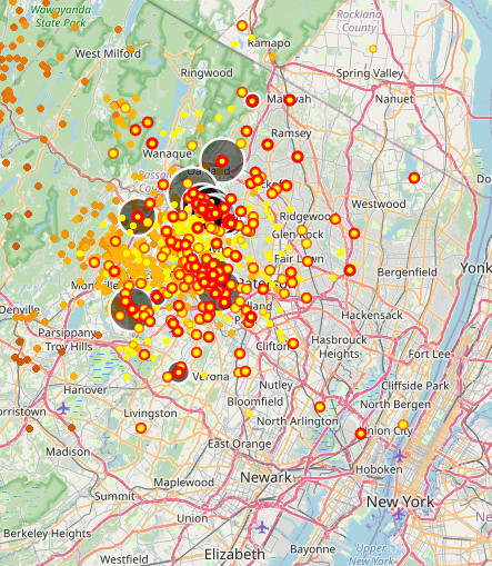
There's a whopper going on north of us right now. Check out this lightening map:


Employment Wanted
Latest Jobs
Employment Wanted
-
(Classic Painting and Materials) Fair Prices. Spring and Summer Specials
Apr 25, 2024 at 5:14pm
-
Apr 25, 2024 at 8:08am
-
Apr 24, 2024 at 1:13pm
-
****Laundry + Bedrooms Organization : closets,drawers,shelves
Apr 24, 2024 at 8:04am
Help Wanted
-
Apr 25, 2024 at 6:15pm
-
PF504 FT Companion/FA for 16 Year Old (ASAP Start)
Apr 25, 2024 at 4:05pm
-
Apr 25, 2024 at 12:24pm
-
Part-time long term Nanny for toddler boy in Basking Ridge
Apr 24, 2024 at 7:49pm
-
PF802 FT M-Th Nanny for 2 (ASAP Start)
Apr 24, 2024 at 1:21pm
-
Photo Booth Attendant- Great for high school senior, college student, profeessional
Apr 24, 2024 at 5:55am
Lessons/Instruction

Featured Events
-
Stephen Whitty Presents - Hometown Movie Stars: The Celebrated Actors Of CHS
May 6, 2024 at 7:00pm
-
'Beethoven's Wrong Note: A Steampunk Opera'
May 12, 2024 at 2:00pm


Advertisement


Severe Thunderstorm Watch this afternoon and evening, Monday July 18th
The NWS has issued a Severe Thunderstorm Watch for most of New Jersey. Thunderstorms will continue to develop and move through the area for the rest of the day. Any storm could present with strong gusty winds, lightening, and hail.
A Watch indicates that conditions exist for a weather event to happen. Please keep an eye on any alerts from your weather app or the NWS for a storm Warning, which would mean a severe storm is in the area or immanent. As always, please don't depend on me for timely warnings.
From the national weather service:
Severe Thunderstorm Watch
SEVERE THUNDERSTORM WATCH OUTLINE UPDATE FOR WS 473NWS STORM PREDICTION CENTER NORMAN OK145 PM EDT MON JUL 18 2022
SEVERE THUNDERSTORM WATCH 473 IS IN EFFECT UNTIL 1000 PM EDT FOR THE FOLLOWING LOCATIONS
NJC003-005-007-013-015-017-019-021-023-025-027-029-031-033-035-037-039-041-190200-/O.NEW.KWNS.SV.A.0473.220718T1745Z-220719T0200Z/
NJ. NEW JERSEY COUNTIES INCLUDED ARE
BERGEN BURLINGTON CAMDEN ESSEX GLOUCESTER HUDSON HUNTERDON MERCER MIDDLESEX MONMOUTH MORRIS OCEAN PASSAIC SALEM SOMERSET SUSSEX UNION WARREN