SEVERE THUNDERSTORM WATCH OVER:

Keep an eye on the weather for alerts, watches, and warnings. Warnings in particular pop up with relatively short notice in these conditions, please do not rely on me getting a warning posted here.
If you hear thunder or see lightning, seek shelter immediately. Storms can move quickly and distant thunder might only be 5 minutes from directly overhead.
There is a 60% chance of precipitation this evening.

Thanks for this info, max. My son has a baseball game in Union County plus I have to be in Caldwell later this evening and wasn't aware of the forecast. You're a gem!
Severe Thunderstorm Watch
SEVERE THUNDERSTORM WATCH OUTLINE UPDATE FOR WS 395
NWS STORM PREDICTION CENTER NORMAN OK
1205 PM EDT MON JUL 18 2016
SEVERE THUNDERSTORM WATCH 395 IS IN EFFECT UNTIL 800 PM EDT
FOR THE FOLLOWING LOCATIONS
NJC003-013-017-019-021-023-025-027-031-035-037-039-041-190000-
/O.NEW.KWNS.SV.A.0395.160718T1605Z-160719T0000Z/
NJ
. NEW JERSEY COUNTIES INCLUDED ARE
BERGEN ESSEX HUDSON
HUNTERDON MERCER MIDDLESEX
MONMOUTH MORRIS PASSAIC
SOMERSET SUSSEX UNION
WARREN
$

This is a watch, keep an eye out for warnings, which would mean severe weather is imminent

Make sure it's at exactly 5:15 as I leave the Library and run to my car to drive home. 
Starting to rain and thunder in South Orange. It's pretty dark out there.

max_weisenfeld said:
...or maybe a bit sooner...
I am planning everything around your earlier estimate of 5-5:30. Mostly because I already had dinner on the grill when the heavens opened.


wow! Just rolled through here and the whole street is flooded and tree branches everywhere! That was really fast and really powerful!
The worst went on either side of MAPSO, especially to the south.
There is still activity to the west -- the watch continues until 8:00

I was talking with a friend in Roselle Park and they got the storm bad.. Heavy rain, wind, thunder and lightning bolts. Hope we escaped !
Thanks for the updates Max !
kthnry said:
We got almost nothing in South Orange.
For this, I am thankful. On Thursday, a branch flew off a big old tree in my backyard and shattered the glass top of the patio table on my deck into eighty bigazillion pieces.


Hazardous Weather Outlook
HAZARDOUS WEATHER OUTLOOK
NATIONAL WEATHER SERVICE NEW YORK NY
537 AM EDT MON JUL 18 2016
CTZ005>012-NJZ002-004-006-103>108-NYZ067>074-078-079-176-177-190945-
NORTHERN FAIRFIELD-NORTHERN NEW HAVEN-NORTHERN MIDDLESEX-
NORTHERN NEW LONDON-SOUTHERN FAIRFIELD-SOUTHERN NEW HAVEN-
SOUTHERN MIDDLESEX-SOUTHERN NEW LONDON-WESTERN PASSAIC-
EASTERN PASSAIC-HUDSON-WESTERN BERGEN-EASTERN BERGEN-WESTERN ESSEX-
EASTERN ESSEX-WESTERN UNION-EASTERN UNION-ORANGE-PUTNAM-ROCKLAND-
NORTHERN WESTCHESTER-SOUTHERN WESTCHESTER-NEW YORK (MANHATTAN)-BRONX-
RICHMOND (STATEN ISLAND)-NORTHWESTERN SUFFOLK-NORTHEASTERN SUFFOLK-
NORTHERN QUEENS-NORTHERN NASSAU-
537 AM EDT MON JUL 18 2016
THIS HAZARDOUS WEATHER OUTLOOK IS FOR SOUTHERN
CONNECTICUT...NORTHEAST NEW JERSEY AND SOUTHEAST NEW YORK.
.DAY ONE...TODAY AND TONIGHT.
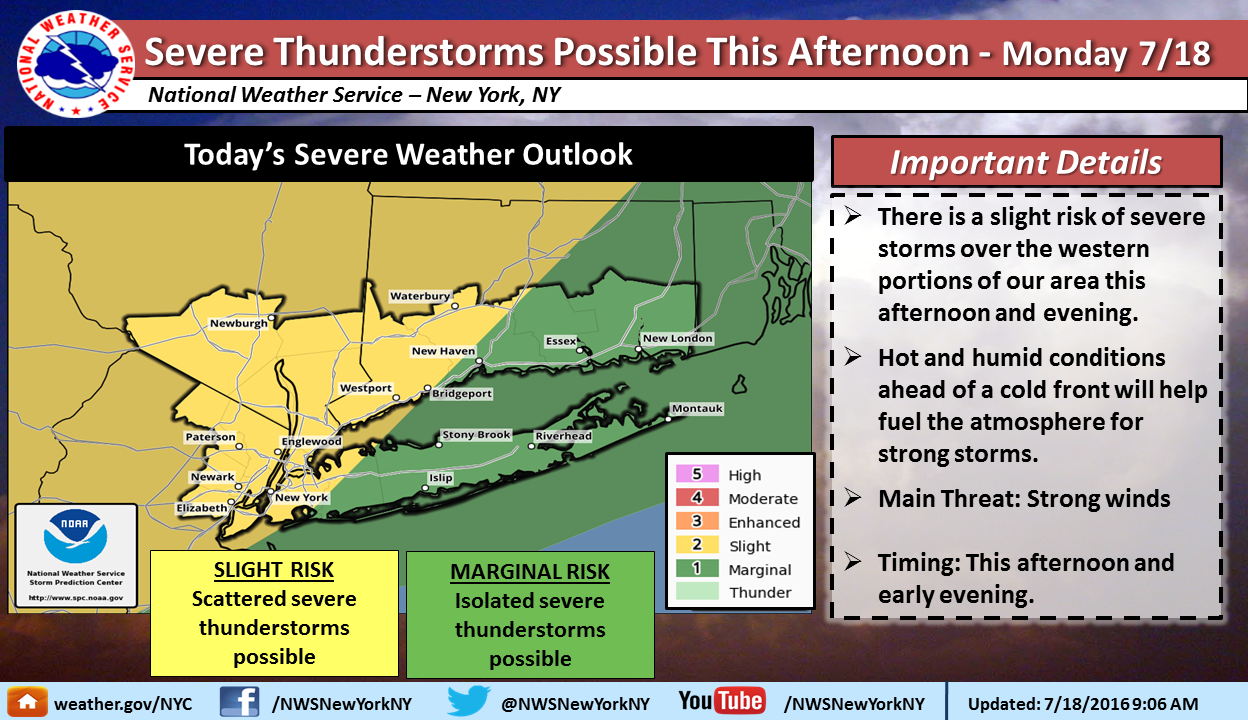
STRONG TO POSSIBLY SEVERE THUNDERSTORMS ARE PROBABLE THIS AFTERNOON
AND EVENING. THE MAIN THREAT IS STRONG DAMAGING WINDS.
.DAYS TWO THROUGH SEVEN...TUESDAY THROUGH SUNDAY.
NO HAZARDOUS WEATHER IS EXPECTED AT THIS TIME THAT WOULD MEET
NATIONAL WEATHER SERVICE WARNING CRITERIA.
.SPOTTER INFORMATION STATEMENT...
SPOTTER ACTIVATION MAY BE NEEDED.
&&
THIS HAZARDOUS WEATHER OUTLOOK PROVIDES A SUMMARY OF POTENTIAL
WIDESPREAD HAZARDOUS WEATHER EVENTS THAT MAY REACH NWS WARNING
CRITERIA. MOST LONG FUSED NWS WATCHES...WARNINGS AND ADVISORIES IN
EFFECT ARE HIGHLIGHTED.
PLEASE REFER TO THE LATEST NWS FORECASTS FOR WEATHER NOT MEETING NWS
WARNING CRITERIA.