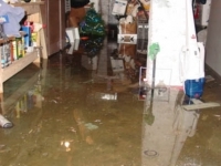
Little-known Ida flood damage in Newstead

That's a very cool website. However, it looks like they are measuring and displaying the risk of flood damage, rather than actual flood damage. It would be interesting to see how actual damage from Ida compared to their maps.

It's quite a problem. I don't think there are any ways to manage most of the flooding when you have a storm like Ida. I suppose that in Millburn, the Army Corp of Engineers scheme to build a large flood control dam in the reservation would work, but on our branch of the Rahway we have no such option.

Yes, you are correct YY. Reading the map heading again indicates that. And when I zoom in on Kendal and surrounding streets, I see that most of the individual homes which first appeared to be Kendal homes are, in fact, on Headley. The map did not capture a good number of Kendal homes that were flooded (based on my observation the day after). Plus, homes everywhere could have had home flooding because of hyper local factors, like grading/downspout discharge/ etc.


Employment Wanted
Latest Jobs
Employment Wanted
-
Begin preparing now for the March 8th SAT.
Jan 4, 2025 at 8:26pm
Help Wanted
Lessons/Instruction

Sponsored Business


Promote your business here - Businesses get highlighted throughout the site and you can add a deal.
Advertisement


I was most familiar with damage in Maplewood, so I wanted to see how accurate and detailed the map was.
https://floodfactor.com/zip/07040/7040_fsid