There is a chance we could wake up to a bit of snow tomorrow morning. There is a very slight chance it could be more than a bit.
A low pressure system developing over the southeastern USA today is likely to become a Winter Storm crossing to our south overnight and tomorrow. Almost all the model elements have the storm passing south of the MAPSO area, but not by much, with parts of Delaware and Maryland forecast for up to 6 - 8" of snow. The chances of this storm ticking north enough to significantly impact us are small but not zero.
Forecast: less than an inch of accumulation over several hours starting in the wee hours Monday morning.
Keeping an eye on Wednesday, too. So far I'm not too impressed.
I mean, we knew we’d get our share eventually. I was just hopeful it might not be for awhile longer…I’m fascinated that Atlantic City could get so much snow. I always forget boardwalk towns get slammed, too.
My spouse and I are flying home Tuesday and we got an alert from United about winter weather in the Northeast with an offer for a free change of reservation by one day in either direction. But it looks to me as if Tuesday is our best bet (also for our connection through Chicago.)
It makes me wonder if United is anticipating more Covid-related cancellations and is using the weather as an excuse to get people to change reservations voluntarily (?)
Forecast for chance of light snow in the MAPSO area is on track this morning.
Reports of snow falling as far north as Seaside and Barnegat at the shore as a winter storm passes south of us today. We remain on the far northern edge of a sharp-edged precipitation shield, and could see anywhere from 0 to 2 inches today, with the probabilities heavily on the 0 to 1/2 inch side. Snow most likely midday.
Mostly Rain tomorrow, Wed Jan 5. Chance of Snow for Fri Jan 7
As of now, Tues morning 1/4, tomorrow morning looks like rain, although in the early hours it might get close to freezing so be careful if you are out before dawn.
There is a fairly good chance we will wake up to an inch or so of snow Fri morning, with more falling to a total of maybe 1 - 3 inches by early afternoon.
URGENT - WINTER WEATHER MESSAGE
National Weather Service New York NY
346 PM EST Tue Jan 4 2022

NJZ002-004-006-103>108-050500-
/O.NEW.KOKX.WW.Y.0002.220105T0900Z-220105T1500Z/
Western Passaic-Eastern Passaic-Hudson-Western Bergen-
Eastern Bergen-Western Essex-Eastern Essex-Western Union-
Eastern Union-
346 PM EST Tue Jan 4 2022

...WINTER WEATHER ADVISORY IN EFFECT FROM 4 AM TO 10 AM EST
WEDNESDAY...

* WHAT...Freezing rain expected. Total ice accumulations of a
  light glaze.

* WHERE...All of northeast New Jersey.

* WHEN...From 4 AM to 10 AM EST Wednesday.

* IMPACTS...Very slippery sidewalks, roads and bridges are
  possible. The hazardous conditions could impact the morning
  commute.

PRECAUTIONARY/PREPAREDNESS ACTIONS...

Slow down and use caution while traveling. Prepare for possible
power outages.

Check local Department of Transportation information services for
the latest road conditions.

&&
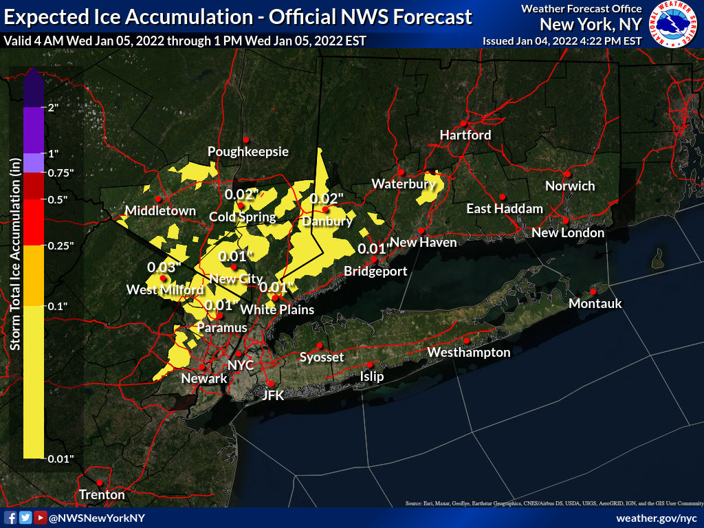
More on the Winter Weather Advisory for tomorrow morning:
Light precipitation will start after midnight tonight. Although precipitation may start as snow, it will change over over the course of the morning to rain. During the transition, there could be a period of 2 - 4 hours of freezing drizzle or light rain. At some point in the early to mid morning a glaze of ice could form, making travel difficult or dangerous.
Precipitation will change to all rain by noon and end by mid afternoon. Icing is more likely at higher elevations.This is not going to be a tree-felling, power outaging ice storm. The main concern here is slippery surfaces -- steps, sidewalks, driveways, and streets could be hazardous for a few hours, so be careful and stay home if you can until midday.
Winter Weather Advisories are issued when snow, blowing snow, ice, sleet, or a combination of these wintry elements is expected but conditions should not be hazardous enough to meet warning criteria. Be prepared for winter driving conditions and possible travel difficulties. Use caution when driving. More details on what the NWS winter weather alerts mean can be found here: https://www.weather.gov/safety/winter-ww
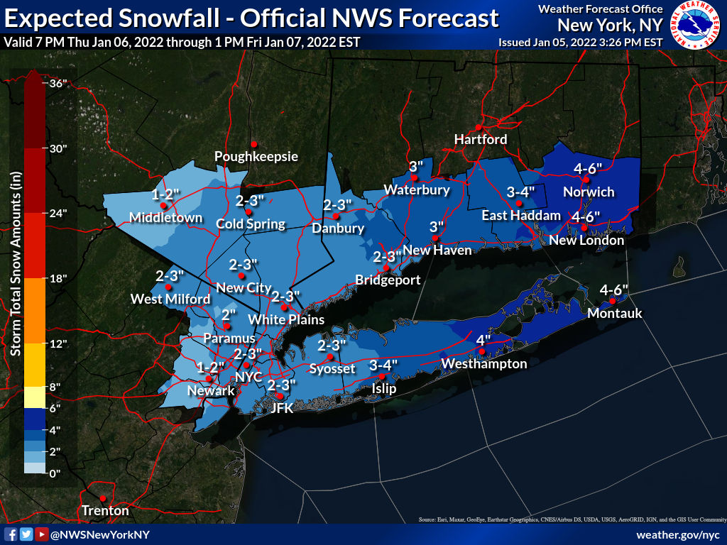
Snow Forecast for Overnight Thursday - Friday, 1/6 - 1/7
A strong winter storm will pass well to our east Thursday night into Friday morning. We will just catch the western edge. Based on the current forecast track, the storm will deposit 1 - 3 inches of snow on our immediate area. There are a couple of factors still at play here, mostly having to do with the storm track, that could increase or decrease the snowfall a bit, another inch or two in either direction. That is likely to be a 'nowcast' situation, as in we will only know the score for sure when the game is over. Part of the issue is temperature -- a slightly colder profile will increase the snow depth without increasing the amount of water that falls (fluffy versus wet snow).At this time I expect the snow to start falling just after midnight and continue into Friday morning, messing up the commute yet again. This forecast puts us just below the NWS Advisory Criteria. Any change though could generate a Winter Weather Advisory. No freezing rain or icing is expected at this time.
A strong winter storm will pass well to our east Thursday night into Friday morning. We will just catch the western edge. Based on the current forecast track, the storm will deposit 1 - 3 inches of snow on our immediate area.
There are a couple of factors still at play here, mostly having to do with the storm track, that could increase or decrease the snowfall a bit, another inch or two in either direction. That is likely to be a 'nowcast' situation, as in we will only know the score for sure when the game is over. Part of the issue is temperature -- a slightly colder profile will increase the snow depth without increasing the amount of water that falls (fluffy versus wet snow).
At this time I expect the snow to start falling just after midnight and continue into Friday morning, messing up the commute yet again. This forecast puts us just below the NWS Advisory Criteria. Any change though could generate a Winter Weather Advisory. No freezing rain or icing is expected at this time.
Overnight model runs have the storm tracking a bit further west so upped the snow totals to 3 - 6 inches. NWS service is a bit more bullish at 4 - 6. Rest of the forecast remains the same, with an all snow event starting about midnight tonight and running through mid morning Friday.
There is a chance of some heavier snowfall during the commute tomorrow morning.
~~~~~~~~~~~~~~~~~
From the NWS:
Winter Weather Advisory
URGENT - WINTER WEATHER MESSAGE
National Weather Service New York NY
355 AM EST Thu Jan 6 2022
NJZ002-004-006-103>108-NYZ069>075-176-178-062100-
/O.NEW.KOKX.WW.Y.0003.220107T0500Z-220107T1700Z/
Western Passaic-Eastern Passaic-Hudson-Western Bergen-


Snow tomorrow (Mon Jan 3)?
There is a chance we could wake up to a bit of snow tomorrow morning. There is a very slight chance it could be more than a bit.
A low pressure system developing over the southeastern USA today is likely to become a Winter Storm crossing to our south overnight and tomorrow. Almost all the model elements have the storm passing south of the MAPSO area, but not by much, with parts of Delaware and Maryland forecast for up to 6 - 8" of snow. The chances of this storm ticking north enough to significantly impact us are small but not zero.
Forecast: less than an inch of accumulation over several hours starting in the wee hours Monday morning.
Keeping an eye on Wednesday, too. So far I'm not too impressed.