Winter Weather Advisory: Snow, Sleet, Rain Tuesday Feb 12

Kids are wondering whether we are going to have any sledding opportunities this year. Its been cold plenty of times, what's with the lack of playable snow?

Winter Weather Advisory Tuesday Feb 12th All Day and Overnight
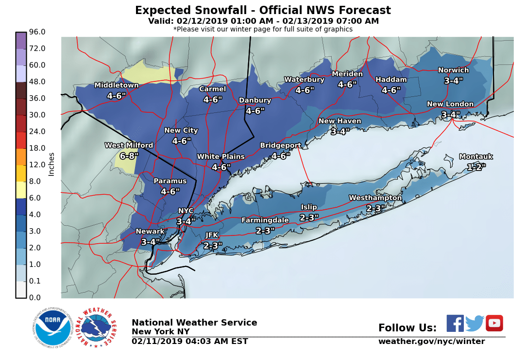
Snow will develop very early Tuesday morning, later mixing with sleet. Possible accumulation of 2 - 6"
Snow and sleet should changeover to rain in the afternoon. There is a possibility of freezing rain during the changeover. Little ice accumulation in the MAPSO area is expectted at this time, however icing could be serious north and west of us. Rain likely Tuesday afternoon and into the night, possible heavy at times.
Although there is good agreement in the forecast that there will be significant water in the storm, 1 - 2", there is wide disagreement in the models as to what form that water will fall at what time of day.
Snow or mixed snow and sleet could make the morning commute messy. Although we are only expecting a couple of hundredths of inches of ice, it is possible the icing could occur around afternoon school dismissal time. The evening commute should be better, with rain.
From the NWS:
Winter Weather Advisory
URGENT - WINTER WEATHER MESSAGE
National Weather Service New York NY
418 AM EST Mon Feb 11 2019
...WINTER WEATHER ADVISORY IN EFFECT FROM 6 AM TUESDAY TO 6 AM
EST WEDNESDAY...
* WHAT...Mixed precipitation expected. Total snow accumulations of
2 to 5 inches and ice accumulations of a light glaze to up to one
tenth of an inch expected.
* WHERE...Portions of northeast New Jersey, southern Connecticut
and southeast New York.
* WHEN...From 6 AM Tuesday to 6 AM EST Wednesday.
* ADDITIONAL DETAILS...Plan on slippery road conditions. The
hazardous conditions could impact the morning and evening
commutes.
PRECAUTIONARY/PREPAREDNESS ACTIONS...
A Winter Weather Advisory means that periods of snow, sleet or
freezing rain will cause travel difficulties. Expect slippery
roads and limited visibilities, and use caution while driving.
Check local Department of Transportation information services for
the latest road conditions.


With all due respect to Max, we don’t need two threads on the same subject. Please post this on the assisted suicide thread where it belongs

spontaneous said:
With all due respect to Max, we don’t need two threads on the same subject. Please post this on the assisted suicide thread where it belongs
I am SO confused.


I believe it is a joke. Read it like a teen saying: "Just kill me now".
sprout said:
I believe it is a joke. Read it like a teen saying: "Just kill me now".
Are you saying I have the maturity level of a 14 year old? 
Eh, I can’t say anything, you’re absolutely right 
The models are coming into better agreement on the timing of tomorrow's (Feb 12th) storm but there is still some uncertainty with the timing of the changeover midday. Models are in good agreement over the overall profile, timing, and amount of water (QPF) in the system.
Light snow should develop in the morning becoming heavier as the morning goes on. By late morning or early afternoon sleet will begin to mix in with the snow. Total accumulation of snow and sleet should be in the 2 - 6" range, with the NWS liking a lower 2 - 4" range on their forecast.
Midday the snow/sleet will start to slowly change over to rain. During the changeover there may be periods of freezing rain. Although not a lot of ice is expected (less than 1/10") there could be enough of a glaze to make untreated surfaces very slippery.
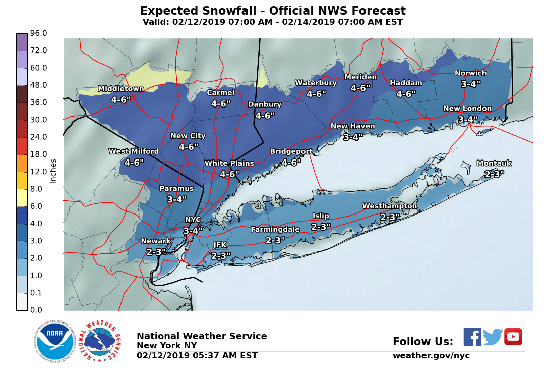
Later Tuesday afternoon precipitation should change over to all rain. Temps will be slow to get far above freezing but once they get there they should stay there for the rest of the day and continue rising as the rain continues Tuesday night.
The morning commute could be impacted by snow falling. In the afternoon, school pickups could be hampered by sleet and freezing rain. The evening commute might still include some sleet and freezing rain but will be heading for all rain a bit later.
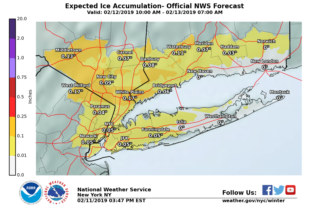

Right now the cold dry air mass is holding position a bit longer than was expected, and the warmer wet air is moving in more slowly with the snow. The latest runs of the short-term models show snow developing from the south before 9:00 this morning and mixing with sleet by midday. Freezing rain could mix in by noon, with the changeover to all rain now not happening until later this afternoon. This would lower the snow/sleet total to 2 - 4" and potentially increase the risk of up to a tenth of an inch of ice. With the overall temperature profile higher here in this scenario, I still think the ice danger is real on the ground but still not a major risk to trees and power lines, but it bears watching over the next few hours. Rain should continue most of the night.


Any thoughts on the best time to shovel? There doesn't seem to be much accumulation, but we don't want to wait until there's a layer of ice.

Oh, I was hoping the rain would be sufficient to wash all the snow/ice away, no shoveling required.
It's ten to two. If you are out now, go home.
The upper air is warming up, and this sleet is going to change over to rain shortly. Since the surface temperature is 25 here in eastern Maplewood, when that rain hits the ground, it is going to freeze. The roads and sidewalks are going to deteriorate pretty quickly, and this could keep up for several hours.
I do not expect the sort of heavy icing that brings down trees and power lines, but I do expect there to be skidding SUVs everywhere. Stay safe. Stay home.
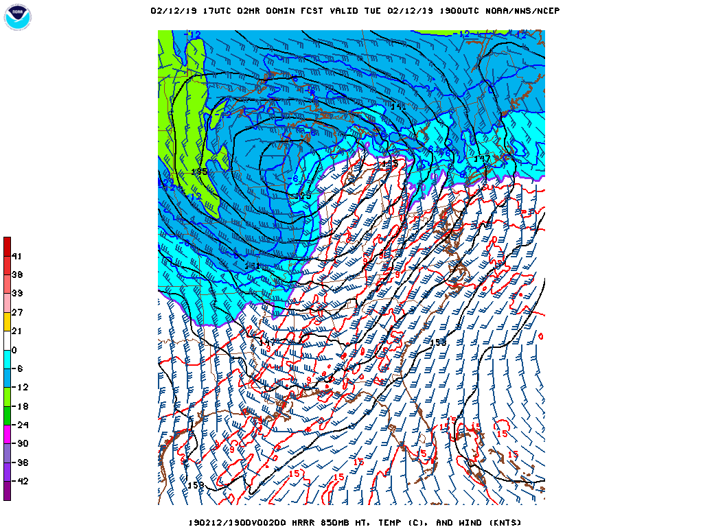
A note on the image. It is the 2:00pm cell from the HRRR model, a very short-range model. If you can find New Jersey, you will see a purple line across the state right about at our latitude. This cell shows the 850 layer, which is the atmospheric layer right above the surface layer, a few hundred feet up. The purple line is the 32 degree line, south of it is above freezing. The precipitation is falling through the 850 layer and melting, which is why we will be having rain. But the surface layer is colder, so the rain freezes on contact with the ground.
Harriet said:
Any thoughts on the best time to shovel? There doesn't seem to be much accumulation, but we don't want to wait until there's a layer of ice.
It is miserable out there now. I am taking the risk and leaving it to tomorrow. Temps will be over freezing by midnight or before, and I am hoping most of it washes away.
Note this is a personal opinion not a forecast! 

Formerlyjerseyjack said: drummerboy said:
Is it over?
max_weisenfeld said:Now?
No
max_weisenfeld said:
....
I do not expect the sort of heavy icing that brings down trees and power lines, but I do expect there to be skidding SUVs everywhere. Stay safe. Stay home. ....
I don't know. People spent a lot of money on their suburban assault vehicles. They are able to go anywheres... deserts, mountains, swamps, King's, Dunk's, Bonji"s.
I see them do it all the time on my tv. A little ice on the road shouldn't be a problem for them.

Formerlyjerseyjack said:
max_weisenfeld said:I don't know. People spent a lot of money on their suburban assault vehicles. They are able to go anywheres... deserts, mountains, swamps, King's, Dunk's, Bonji"s.
....
I do not expect the sort of heavy icing that brings down trees and power lines, but I do expect there to be skidding SUVs everywhere. Stay safe. Stay home. ....
I see them do it all the time on my tv. A little ice on the road shouldn't be a problem for them.
do they show the SUVs stopping when you see them on your TV?

is it the type of rain that will wash away the inch or two that’s on the ground?

Max has a point. I started shoveling at about 2:15 pm and came in about 45 minutes later. The crunchy stuff that I cleared as a test patch filled in with ice. Crunchy is way safer. Guilt ridden or not, I am waiting until tomorrow. Warning: on my block at least, the late arriving plows sprayed ice filled slush the full width of the sidewalk for most of the length of the block. Be very careful if you do decide to walk at this time and make sure you have the right footwear.
well, I called this one wrong. About an inch or two of icy snowy stuff on the driveway. Figured it’d melt. It’s not washing away, is it? No way I’m going out now to shovel.
conandrob240 said:
well, called this one wrong. About an inch or two of icy snowy stuff on the driveway. It’s not washing away, is it? No way I’m going out now to shovel.
No, its not washing away. But it is crunchy. As pointed out earlier, crunchy is safer to walk on than ice.
Let it be and deal with it tomorrow.
“deal with it tomorrow” will mean leaving it until it melts. I’m not going to be breaking up ice, thats for sure. Oh well. I’m comfy here until I fly the coop for warm weather end of the week!

Rentals
-
Huge Brand New construction Apartment in 2 family home with 4 bedrooms 3 bathrooms

4 Bd | 3Full Ba
$4,500
Sponsored Business


Promote your business here - Businesses get highlighted throughout the site and you can add a deal.

Advertisement


I am away traveling and will have limited time to post until late on Monday but you should be aware of the potential for an advisory level (2 - 4") snowfall Tuesday (2/12) morning, likely followed by sleet and rain. I will post when I can.
In the meantime, I recommend this link for the most accurate forcast: https://forecast.weather.gov/MapClick.php?lat=40.73092287349289&lon=-74.26575924279399