Winter Weather Advisory overnight Tuesday Jan 16 into Wednesday

Max can even make some coming snow a "Sunny" Forecast!
Thanks, Max
Ron Carter

Is this forecast different from what they were initially reporting? 2-4 is no biggie but it seems to be more than what I heard on the radio this morning.
Issuing Office: New York City
Source: National.Weather.Service
3:02pm EST, Mon Jan 15
... WINTER WEATHER ADVISORY IN EFFECT FROM 10 AM TUESDAY TO 1 PM EST WEDNESDAY... * WHAT... SNOW EXPECTED TO INCREASE INTO TUESDAY EVENING. PLAN ON SLIPPERY ROAD CONDITIONS. TOTAL SNOW ACCUMULATIONS OF 2 TO 4 INCHES ARE EXPECTED. * WHERE... PORTIONS OF NORTHEAST NEW JERSEY AND SOUTHEAST NEW YORK. * WHEN... FROM 10 AM TUESDAY TO 1 PM EST WEDNESDAY. * ADDITIONAL DETAILS... SNOW MAY INITIALLY BE LIGHT BEFORE BECOMING STEADIER THROUGH THE EVENING. BE PREPARED FOR REDUCED VISIBILITIES AT TIMES. PRECAUTIONARY/PREPAREDNESS ACTIONS... A WINTER WEATHER ADVISORY FOR SNOW MEANS PERIODS OF SNOW WILL CAUSE PRIMARILY TRAVEL DIFFICULTIES. BE PREPARED FOR SNOW COVERED ROADS AND LIMITED VISIBILITIES, AND USE CAUTION WHILE DRIVING.


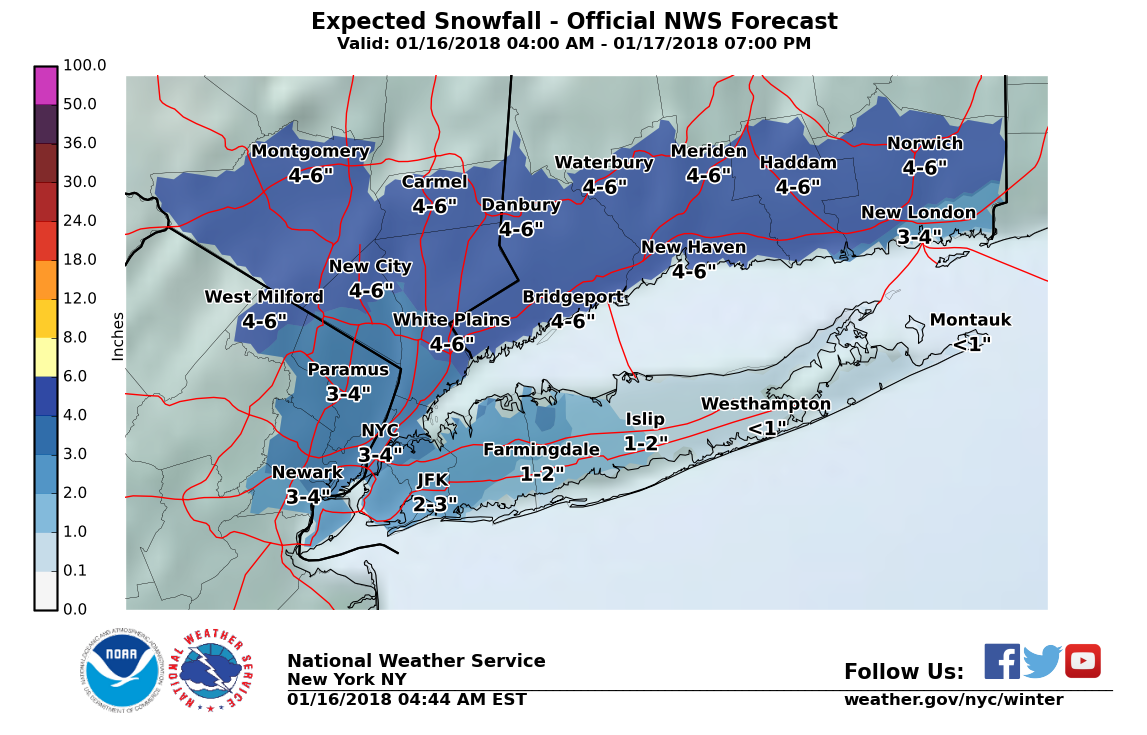
The models have ticked a little west this afternoon, so the NWS has issued a Winter Weather Advisory for our area, showing IMHO an abundance of caution. Snow is likely to begin Tuesday evening or night, and continue into Wednesday morning. Overnight could snow steadily at times, but accumulation of more than 2" is still a long shot. Snow ends by midday Wednesday.


Overnight shifts in the forecast track of the snow have moved things a bit further west, resulting in a bit more snow but also moving us closer to the rain/snow line.
As a result, bumping snow prediction up to 2-4"
Also expecting the snow to start a bit later, mostly after midnight Tuesday into Wednesday.
As luck would have it, I'm planning a conference tomorrow morning that 100 people are attending in East Hanover. Max - I know you don't have a crystal ball but do these storms ever change last minute (hoping for all rain!).
Having run many meetings in NJ Weather, you probably don't have any issues with people coming from the south and west, possibly those from Northern NJ might want to take the train? or Bus?
Study Max's map carefully.
Tell then not to drive but us public trans.
Best Regards,
Ron Carter

When is the snow expected to end? (Trying to gauge likelihood of a delayed opening)
gegreenstein said:
As luck would have it, I'm planning a conference tomorrow morning that 100 people are attending in East Hanover. Max - I know you don't have a crystal ball but do these storms ever change last minute (hoping for all rain!).
All rain is very unlikely for interior NJ

oakland2 said:
When is the snow expected to end? (Trying to gauge likelihood of a delayed opening)
Midday Wednesday

Does anyone know the latest? I have a Conference that was just pushed back from 4:00 today until around 6:00, but I'd rather due it at 9:00 AM tomorrow.

Accuweather is saying 3-5, with snow starting at 6PM. I'd do it tonight rather than tomorrow.

Greeeeeat. Flight to Chicago (of all places) at 3pm, with that plane due in to EWR from ORD only an hour before. Argh.
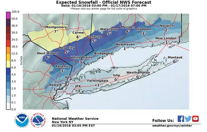
System track has ticked west again, shifting the rain/snow line across our area. This means temperatures are likely to hover at or above freezing for most of the night and Wednesday morning, making snow accumulation less likely. Freeezing rain is possible but serious icing is not likely.
Snow could still be 2-3" but it is very possible it will wash away with the rain. It will be very hard to forecast exactly where the rain/snow line will set up, but overall this will reduce the chances of there being extraordinary issues with the commute tomorrow morning. Further west will be more likely to experience accumulating snow, east more likely to see rain.

or not. looks like somebody's keeping us warm. Maybe we'll luck out and stay rainy.
We are currently sitting right on the rain snow line.
Decreasing precipitation throughout the morning could be in the form of rain or snow. Accumulation of less than an inch if snow occurs.

Does anyone know what the conditions are in Summit? Family member needs to get to Overlook midday.
Changeover happened about 6:30 here in eastern Maplewood.
Snow ends about midday, but snow should continue to be fairly light until then.

Employment Wanted
Latest Jobs
Employment Wanted
-
Nomadic Notary: Professional Notary Services Available!
Apr 22, 2024 at 3:43pm
-
Apr 22, 2024 at 12:46pm
-
Apr 22, 2024 at 10:49am
-
Apr 20, 2024 at 8:18pm
-
Brazilian cleaning 973 776 2481
Apr 20, 2024 at 4:48pm
Help Wanted
-
Part time Driving Sitter Needed (Start ASAP)
Apr 23, 2024 at 1:18pm
-
CKF600 Part Time Nanny for Toddler (ASAP Start)
Apr 22, 2024 at 3:21pm
-
Full Time Nanny Needed for 2 in Essex County (June/July Start)
Apr 20, 2024 at 8:42pm
-
NPF509 FT Nanny/Family Assistant for Twins (ASAP Flex)
Apr 19, 2024 at 12:38pm
-
CF582 FT Nanny/Family Assistant for 2 (Late May Start)
Apr 19, 2024 at 12:18pm
Lessons/Instruction

Featured Events
-
Stephen Whitty Presents - Hometown Movie Stars: The Celebrated Actors Of CHS
May 6, 2024 at 7:00pm


Advertisement


There is a 50/50 chance of light snow Tuesday and Tuesday night. Although total accumulation might reach 1 - 2" this would be over many hours, and should not be disruptive.