More traffic at Parker & Valley-proposed 46 units at Gleason site


mrmaplewood said:
A thought before you express opinions, speak whereof you have experience or knowledge.
Well, it ain't from Fox News.
Parking and traffic ---
Traffic: When school is open, it can take as much as 15 minutes to get from my house, Essex Ave., to Valley and Millburn Ave. -- a distance of about 2 1/2 miles.
Parking, since Covid, at least 25 village parking spaces were eliminated for outdoor dining (Al Fresco, for the more sophisticated, like me. I don''t know why Al needs 25 spaces. Also, the barriers are ugly. But this leads to frustrated searches for parking. Given that a lot of money has been spent by food establishments for the more permanent structures, I doubt they will go away.
But the fact remains: More residents mean more traffic and more people searching for parking.

joan_crystal said:
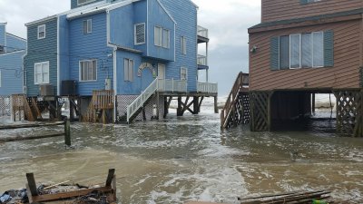
Those of us who experienced flood conditions during the storm in which one resident died trying to clear debris to aid drainage of the flood waters, knew others who were nearly swept away but survived harrowing rescues, know first hand what storms can do given our present climate. We don’t want to see further loss of life. We want to do what we can to reduce the kind of flood damage to public and private property that resulted from Ida. Not all of us are opposed to new construction but most of want to see that construction done responsibly. That means building in such a way as to withstand the storms we are getting now and building with an understanding of what our infrastructure and topography can reasonably be expected to support.
Raising buildings in areas that flood is a solution that is being adopted throughout effected areas and one that is being used in this case as well.
In the years that I have followed MAPSO politics, there has always been a "legitimate objection" to any project that would increase density and provide more housing for people without increasing sprawl. After a while, one begins to suspect that some if not most of these "legitimate objections" are really just NIMBYism.
In this case, the "legitimate objection" is something that is easily solved for and that the builders have, indeed, mitigated by leaving the first floor open for parking.

GoSlugs, what's your perception with regard to the traffic around here?

I don’t think you can look at increased apartment stock as the sole reason for increased traffic over the last, say, 20 years.
I have lived in Maplewood and South Orange since 2000. My job has me in the car almost every day. I have not noticed an appreciable increase in traffic in that time, but maybe it’s a “frog in boiling water” situation where the change has happened gradually enough that I haven’t noticed it. Hard statistics would be helpful. Census data shows an increase of about 1800 people from 2010 to 2020 for both towns.
You can’t ignore the fact that public transit ridership is down since the pandemic. Lots more people in their cars. Likewise more people are in the two towns during the day because of remote work. I don’t know about you but if I am having a home office day, I’m often hopping in the car for a quick local trip to CVS or Stop and Shop. Could that be contributing to more traffic?
I’m not saying another apartment building close to the Valley/Parker intersection won’t cause incrementally more traffic. But there are other factors to consider besides a bunch of apartments (which are largely within walking distance of shopping and dining).
It is also my perception that you can’t swing a dead cat in this area with hitting an Amazon delivery van that’s blocking half (or more) of a travel lane so the driver can make their delivery. Always fun to have to wait to squeeze around one of those. Add in other delivery vehicles and that fabulous Wonder Truck and I think you have another cause for worsening traffic. That has nothing to do with increased apartment stock.

mrincredible said:
I don’t think you can look at increased apartment stock as the sole reason for increased traffic over the last, say, 20 years.
I have lived in Maplewood and South Orange since 2000. My job has me in the car almost every day. I have not noticed an appreciable increase in traffic in that time, but maybe it’s a “frog in boiling water” situation where the change has happened gradually enough that I haven’t noticed it. Hard statistics would be helpful. Census data shows an increase of about 1800 people from 2010 to 2020 for both towns.
You can’t ignore the fact that public transit ridership is down since the pandemic. Lots more people in their cars. Likewise more people are in the two towns during the day because of remote work. I don’t know about you but if I am having a home office day, I’m often hopping in the car for a quick local trip to CVS or Stop and Shop. Could that be contributing to more traffic?
I’m not saying another apartment building close to the Valley/Parker intersection won’t cause incrementally more traffic. But there are other factors to consider besides a bunch of apartments (which are largely within walking distance of shopping and dining).
We moved into S.O. In 1999. I mainly encounter significantly more traffic on the way to and from the train station in SO at peak hours - mostly on 3rd Street in South Orange and also on Walton approaching Third, driven primarily by drop offs at SOMS. I know that Parker approaching CHS is difficult at school open and close as well. Non-commute hours are pretty traffic-free, as long as one avoids Valley and SO Aves, which I think most of us have learned to do.
But to blame the additional traffic on the apartments is not correct, in my somewhat-educated opinion. South Orange’s planners surveyed traffic and found that the significant increases in traffic on Valley Street /Scotland and S.O. Ave. are due to increased through-traffic, people who do not live in our towns just driving through. Waze effect, maybe? Not sure now to stop people driving through…
In the morning, the issue could be alleviated by reducing parents’ dropping their kids at school. A few collector buses on the main drags and maybe some signal timing changes could do a world of good.
As to the flooding, the developers are willing to take the risk and as long as the prospective residents are adequately informed and granted the ability to move their vehicles to higher ground in the event of major storms, who are we to deny people access to greatly-needed housing?
I agree about the school drop-off situation. My SOMS student would usually walk but if it was really cold I would drive. I usually would pull up a side street and park to let them out rather than get into the scrum behind the school. A half block walk was never a big deal. Or I’d park on Mead Street by the duck pond.
There’s also the issue of the crossing guards. But they’re keeping the kids safe.
Parker at Valley is a particularly bad problem because there is no way to widen the street and create turning lanes. It’s one of only a few ways to get from one side of town to the other past the train line, and both streets are major thoroughfares. I’m sure Waze directs people to try and turn left on Valley from Parker which is a recipe for a traffic back-up.

Elle_Cee said
Check out pages 36 and 37 for recommendations with regard to flood mitigation. Again, replacing impervious with pervious pavement is recommended.
Any new construction is required to manage runoff such that there will be minimal if any increase in the amount of runoff compared to previous conditions as per DEP rules. https://www.nj.gov/dep/rules/rules/njac7_8.pdf
I agree that permeable pavement and other runoff mitigation techniques should be used whenever impervious surfaces are rebuilt/modified, that said using permeable pavement at this location won't impact the fluvial risk for the building.
The builder here will be required to follow a great deal of regulation with respect to ensuring that this property doesn't exacerbate existing flood hazard downstream. As pointed out above, the builder will have to ensure that the building's first habitable floor is elevated above the BFE and that any structural or mechanical components below the BFE are floodproofed. Finally, the landlord or their agents will have to disclose to renters that the building is in a flood zone, so tenants can make informed decisions about whether they want to rent there and how they can be ready to protect themselves and their property in advance of a flood.
Part of fixing our climate problems is getting more people to live in places with good public transit and good walkability/bike-ability like Maplewood and South Orange. And part of that is going to be using slightly marginal land to build on, but doing so in a way that doesn't reduce the resilience to natural hazards.

mrmaplewood said:
Who says the housing is "much needed", and yes, I am dismayed at the proposed construction and would like to head it off. Is that clear?
Bloomberg, Forbes, and the Times, to pick three:
https://www.forbes.com/sites/forbesbusinesscouncil/2021/05/19/the-housing-crisis-that-will-hit-home/
https://www.nytimes.com/2022/07/14/upshot/housing-shortage-us.html


We missed the run-off mitigation window on the Rahway River by many, many years. The area around the East Branch has been mostly urban for years. I suppose new construction will have to include run-off mitigation and that will help keep the problem from getting worse.
Interesting to note, the West Branch that runs through the reservation drains a lot of undeveloped land and it still turns into a raging torrent during heavy rains. Trap rock doesn't soak up water very well.
Flood mitigation construction on the Gleason site won't do much good since that site will be underwater during heavy rains.
Given that it is a brownfield site, if apartment buildings can be constructed there (as opposed to better land elsewhere), it seems like a good thing.
Before the latest influx of people, according to the 2020 Census, the town had a population of 25,684 on 3.88 square miles of land. That's about 6877 people per square mile, already a fairly high population density for a small town. Residents need to decide on the town's future. They need to wake up and realize that the proliferation of large multifamily buildings may ultimately change the character of the town from suburban to fully urban. Part of the problem is that the population is so transitory that a group vision is difficult to achieve.
Yes, of course, multifamily housing must be built in the Tristate area, especially in light of climate change, which will inevitably drive refugees here. Must city-adjacent small towns, whose appeal has resided in their slower pace and more spread out landscape, bear the brunt of the housing need? They will if their residents don't establish some sort of barrier to untrammeled growth. I don't know what mechanism can prevent this area from turning urban; maybe it doesn't exist. Maybe it shouldn't exist; maybe we should just accept the change.
I'm glad a new Master Plan is being worked on, and I hope the vision for growth will be addressed during its creation.
The Gleason site apartment building is a done deal, and I hope those of you who believe that the flooding issue will be properly addressed by the developers and that buyers will be fully informed are right. My mind is more focused on flood mitigation closer to the Rahway. I don't think it's too late for flood mitigation, certainly along the east side of the river. There's so much asphalt, from the Y's parking lot, to the parking lot next to the Gleason site, to the Stop-and-Shop parking lot. All of that asphalt could be replaced with permeable pavers. I realize this is pie-in-the-sky talk. It's all about money. The town doesn't seem to have it -- it can barely repair its streets -- and the owners of the parking lots are unlikely to invest in repaving. If action is not taken, though, I do believe, based on climate projections, the damage from Rahway flooding will only worsen.
Elle_Cee said:
I don't think it's too late for flood mitigation, certainly along the east side of the river. There's so much asphalt, from the Y's parking lot, to the parking lot next to the Gleason site, to the Stop-and-Shop parking lot. All of that asphalt could be replaced with permeable pavers. I realize this is pie-in-the-sky talk. It's all about money. The town doesn't seem to have it -- it can barely repair its streets -- and the owners of the parking lots are unlikely to invest in repaving. If action is not taken, though, I do believe, based on climate projections, the damage from Rahway flooding will only worsen.
So, every parking log in the Rahway River Basin needs to be modified to put water catchment tanks under the parking lots which then release the water slowly. And every large building will need catchment tanks to capture rain water which then release the water slowly.

Elle_Cee said:
Before the latest influx of people, according to the 2020 Census, the town had a population of 25,684 on 3.88 square miles of land. That's about 6877 people per square mile, already a fairly high population density for a small town. Residents need to decide on the town's future. They need to wake up and realize that the proliferation of large multifamily buildings may ultimately change the character of the town from suburban to fully urban. Part of the problem is that the population is so transitory that a group vision is difficult to achieve.
The number of households in large multifamily buildings (which is what I assume you mean by "urban") is far less than the number in single-family detached houses ("suburban"). And the population is not "so transitory" as you suggest.
Elle_Cee said:
The Gleason site apartment building is a done deal, and I hope those of you who believe that the flooding issue will be properly addressed by the developers and that buyers will be fully informed are right. My mind is more focused on flood mitigation closer to the Rahway. I don't think it's too late for flood mitigation, certainly along the east side of the river. There's so much asphalt, from the Y's parking lot, to the parking lot next to the Gleason site, to the Stop-and-Shop parking lot. All of that asphalt could be replaced with permeable pavers. I realize this is pie-in-the-sky talk. It's all about money. The town doesn't seem to have it -- it can barely repair its streets -- and the owners of the parking lots are unlikely to invest in repaving. If action is not taken, though, I do believe, based on climate projections, the damage from Rahway flooding will only worsen.
Flooding in that branch of the Rahway River is not caused only by parking lots along the river. It's every storm drain servicing all of the streets on the hills on either side of it. An impermeable surface on North Terrace in Maplewood adds as much run-off as a similarly-sized surface in a parking lot next to the river.

Another thing that is overlooked about permeable pavers is what is under them. If the soil is mostly clay the water soaks down a few inches to that and then sheets off almost the same way as if it was surface water.
DanDietrich said:
Another thing that is overlooked about permeable pavers is what is under them. If the soil is mostly clay the water soaks down a few inches to that and then sheets off almost the same way as if it was surface water.
Which is way the West Branch of the Rahway rises so quickly despite draining a mostly undeveloped basis.
That would be fantastic. Catchment tanks, cisterns, swales, rain gardens, pervious pavement -- all types of flood mitigation measures should be considered. I am not sure why none of the 2009-2010 recommendatons seem to have been implemented. From the Rahway River Corridor Study posted above:
fLood haZard area ControL aCt rULes (nJaC 7:13)
the flood hazard area Control act (fhaCa) rules at n.J.a.C. 7:13 include a number of provisions that
protect existing flood hazard areas (flood fringe and floodway) and the adjacent riparian zone. A regulated
flood hazard area exists along all waters with a drainage area of 50 acres or more. In addition, a riparian
zone exists along every regulated water. the rahway river within maplewood will include both a regulated
flood hazard area and a regulated riparian zone.
The riparian zone along the Rahway River will be measured from the top of bank. Based on our field in-
vestigation, the top of bank is either the water ward edge of the retaining wall or the top of the steep, filled
slopes. in accordance with n.J.a.C. 7:13 the flood hazard area Control act (fhaCa) rules, the rahway
river will include a regulated riparian zone. based on our best professional judgment, the riparian zone
should be 50 feet along the rahway river in maplewood in accord with the following:
• The waters are not classified as Category-1 (C-1)
• The waters are not identified as trout-production or trout-maintenance
• The waters do not flow through areas of acid-producing soils
• The waters are not flowing through an area that contains documented habitat for a threatened
or endangered species of plant or animal, which is critically dependent on the regulated water for
survival*
I just listened to a well-informed expert at the NJ Dept. of Consumer Affairs who is involved in the production of Building Permit reports talk about the development issue. I inferred from what he said that one reason that flood mitigation measures along the Maplewood portion of the Rahway haven't been implemented may be that there are issues that extend to towns, besides South Orange, above and below Maplewood, and the NJ Dep has an overarching concern that whatever flood mitigation measures are undertaken don't have a negative impact elsewhere.
He did point out that the construction of multifamily units will have a substantial impact on sewer systems. I wonder what all the building is doing to Maplewood's sewer infrastructure.
He also said that state regulations have no jurisdiction over buildings constructed on less than an acre of land. I don't know whether this relates to the Gleason property.
tjohn said:
DanDietrich said:
Another thing that is overlooked about permeable pavers is what is under them. If the soil is mostly clay the water soaks down a few inches to that and then sheets off almost the same way as if it was surface water.
Which is way the West Branch of the Rahway rises so quickly despite draining a mostly undeveloped basis.
Per the Army Corp's report, the West Branch is 23.5% impervious surface and the East Branch is 38%, so there's certainly a difference but it's not quite as undeveloped as you're thinking. You're right about the West Branch rising very quickly, the average time of concentration for its three sub-basins is ~1hr vs ~2.2hrs for the East Branch. That's primarily driven by the topography of the basin, the West Branch having steep slopes on both sides vs a much more moderate slope on the eastern side of the East Branch.

We are seeing an increase in our sewer bill because of needed sewer work in the Village and in the area by Boyden Avenue where so many of the new multi family buildings have gone up. If we are going to develop more multi family housing, we need to make sure our infrastructure can handle it.
El Cee
"Catchment tanks, cisterns, swales, rain gardens, pervious pavement"
Sounds good, politically correct. But when the floods from hell come down from West Orange, Orange, and South Orange, all these won't amount to spit in the ocean. Even if those upstream towns installed all of these, I can't imagine them making very much difference in hurricane driven rains.
joan_crystal said:
We are seeing an increase in our sewer bill because of needed sewer work in the Village and in the area by Boyden Avenue where so many of the new multi family buildings have gone up. If we are going to develop more multi family housing, we need to make sure our infrastructure can handle it.
I think a lot of this work is repair and upgrade work required because real work has been deferred for the last 40 years. A new generation In government has realized that we need to do this now, even if it costs us.
nohero said:
In the town where I grew up, in Bergen County, and where my Mom still lives, people move their cars from the low-lying parts of town when there's a risk of flooding. That happens a lot of places.
South Orange DPS always moves their vehicles up the hill when heavy rain is predicted.

joan_crystal said:
We are seeing an increase in our sewer bill because of needed sewer work in the Village and in the area by Boyden Avenue where so many of the new multi family buildings have gone up. If we are going to develop more multi family housing, we need to make sure our infrastructure can handle it.
We expanded our sewage capacity in downtown for the Clarus building. Add that to the list of free stuff we gave the developer.
My house was built in 1900. It was the third or fourth on the block. I wonder if the builder paid for part of the sewer main in the street. I'm sure he profited from building the house.
mrmaplewood said:
El Cee
"Catchment tanks, cisterns, swales, rain gardens, pervious pavement"
Sounds good, politically correct. But when the floods from hell come down from West Orange, Orange, and South Orange, all these won't amount to spit in the ocean. Even if those upstream towns installed all of these, I can't imagine them making very much difference in hurricane driven rains.
And our run-off contributes to downstream areas. That helps account for the flooding in Home Depot last year.


Sponsored Business


Promote your business here - Businesses get highlighted throughout the site and you can add a deal.
Featured Events
-
Stephen Whitty Presents - Hometown Movie Stars: The Celebrated Actors Of CHS
May 6, 2024 at 7:00pm


Advertisement


We are certainly not happy about the proliferation of apartment buildings in South Orange and Maplewood and have witnessed a significant increase in traffic on two of the main arteries between the towns -- Valley and Wyoming. Parking, too, has become more problematic in downtown Maplewood. We don't visit South Orange regularly enough to experience parking issues. I'd like to have more facts about the population increase in our towns and not keep relying on a general sense that this growth is uncomfortable. I do know that our taxes keep increasing every year, the roads are not getting repaved in a timely fashion, the Greenway project is still not complete, so the apartment buildings don't seem to be improving the towns' finances much.
I live close enough to the branch of the Rahway to be a direct witness to the devastating effects when it floods. If the Greenway project were completed, there's a solid possibility that it would mitigate flooding. The Gleason's property would probably benefit if recommendations in the following 2010 study were implemented. I haven't read this carefully yet, but one observation that caught my eye had to do with impervious pavement. The parking lot just west of the Gleason's property is an example of impervious pavement that could be replaced with pervious material.
https://rahwayriver.org/news/rahway-river-corridor-study.PDF
Edited to add a previous 2009 study that dealt with a larger portion of the Rahway River Greenway:
https://rahwayriver.org/images/RRAGreenwayPlan.pdf
Check out pages 36 and 37 for recommendations with regard to flood mitigation. Again, replacing impervious with pervious pavement is recommended.