Rain & Breezy Today, Worst of the Nor'easter is Over


Hope we get the much-needed rain without having to deal with downed trees or significant flooding.

As long as the forecast holds, flooding would be limited to small stream and roads that normally flood in heavy rain.

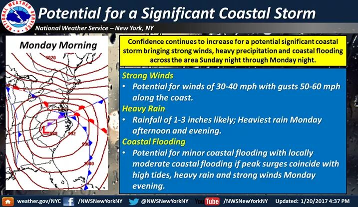
Forecast continues on track for a major nor'easter Sunday night into Tuesday moring, with the highest winds and heaviest rains Monday afternoon.
A slow-moving storm will come up the coast late this weekend, dropping 1 - 3" of rain over about 36 hours. Winds at the height of the storm are now forecast in the 10 - 20 mph range Sunday afternoon and night, rising to 25 - 35 mph during the day Monday, and continuing 10 - 20 mph well into the day on Tuesday.
Storm is expected to be worse nearer the coast, with tidal and coastal flooding. In our area, expect flash flood advisories warning about small stream flooding and ponding on roads.
Temps will start in the low 50s, and drop during the storm into the low 40s.

Max how many inches if this was snow please? Will we even get snow this year? or can I just plant tomatoes now? Thanks!

mem said:
Max how many inches if this was snow please? Will we even get snow this year? or can I just plant tomatoes now? Thanks!
That is what I was wondering as well.
Tonight, Dense Fog Advisory
Dense Fog Advisory
URGENT - WEATHER MESSAGE
NATIONAL WEATHER SERVICE NEW YORK NY
652 PM EST SAT JAN 21 2017
...DENSE FOG TONIGHT INTO SUNDAY MORNING...
...STRONG EAST WINDS LIKELY ALONG THE COAST FROM LATE SUNDAY
NIGHT INTO MONDAY NIGHT...
...DENSE FOG ADVISORY IN EFFECT UNTIL 10 AM EST SUNDAY...
THE NATIONAL WEATHER SERVICE IN UPTON HAS ISSUED A DENSE FOG
ADVISORY...WHICH IS IN EFFECT UNTIL 10 AM EST SUNDAY.
* VISIBILITIES...ONE QUARTER MILE OR LESS AT TIMES.
* TIMING...INTO SUNDAY MORNING.
* IMPACTS...SIGNIFICANTLY REDUCED VISIBILITIES WILL MAKE
TRAVEL DIFFICULT.
PRECAUTIONARY/PREPAREDNESS ACTIONS...
A DENSE FOG ADVISORY MEANS VISIBILITIES WILL FREQUENTLY BE
REDUCED TO ONE QUARTER MILE OR LESS. IF DRIVING...SLOW DOWN...USE
YOUR LOW BEAM HEADLIGHTS...AND LEAVE PLENTY OF DISTANCE AHEAD OF
YOU IN CASE A SUDDEN STOP IS NEEDED.
The models are now in general agreement that we will be experiencing a major coast storm Sunday night through Tuesday, with the most serious effects Monday afternoon into Monday evening..
There is still some disagreement over how long the heavy rain and high winds will last Monday, with the American models a bit quicker out but the Euro trending a bit slower. What this means is we are still unsure as to how late into Monday night the worst of the weather will continue. Our local NWS office in Upton New York, which as of now has not yet been defunded by the new administration, is leaning towards the slower timing, with the longer duration on Monday of rain and winds.
In the MAPSO area, this event will be all rain, with no wintery mix or snow. However, north and east into Connecticut can expect more wintery weather, and caution should be taken if traveling in that direction.
Although there is no High Wind Watch for the immediate MAPSO area, the current watch extends to the border of Maplewood and Irvington, and the wind potential for the storm should be taken seriously.
Forecast:
Sunday, cloudy with rain likely, particularly later in the day. High 51.
Overnight, rain developing, heavy at times. Gusty winds from the northeast at 15 - 20 mph, with gusts of 35 - 40.
Monday, Rain, heavy at times. Winds steady at about 25 mph with gusts of 35 - 40. Any slight deviation of the storm track westward ups the wind forecast 10 mph and the gusts 15.
Monday night. This is where there is still some uncertainty as to timing. Faster NAM takes the worst of the storm through by midnight. Euro is about 4 hours slower.
Tuesday. Rain continues throughout most of the day.
Total rain forecast for the storm is 1 - 2", but 2 - 3" (as I first forecast above) is not off the table. At the higher end, expect some small stream flooding and road ponding, and perhaps a flash flood advisory. The coast faces a Coastal Flood Watch for the Monday evening high tide cycle.

If the forecast were for 25 degrees Monday, this would be 1 - 3 feet of snow.
Because I knew you were going to ask again.

Forecast remains on track this morning for a significant coastal storm tonight through Tuesday, with 1 - 3" of rain and high winds.
The likelyhood of advisory level winds in our area has increased.
Otherwise, forecast is on track as per above.
Dense for advisory continues this morning. Allow extra time for travel.
Wind Advisory
URGENT - WEATHER MESSAGE
NATIONAL WEATHER SERVICE NEW YORK NY
1123 AM EST SUN JAN 22 2017
...STRONG EAST WINDS LATE TONIGHT INTO MONDAY NIGHT...
1123 AM EST SUN JAN 22 2017
...WIND ADVISORY IN EFFECT FROM 1 AM MONDAY TO 1 AM EST TUESDAY...
THE NATIONAL WEATHER SERVICE IN UPTON HAS ISSUED A WIND
ADVISORY...WHICH IS IN EFFECT FROM 1 AM MONDAY TO 1 AM EST
TUESDAY.
* WINDS...NORTHEAST 25 TO 35 MPH WITH GUSTS UP TO 55 MPH.
* TIMING...WINDS COULD BEGIN GUSTING AS HIGH AS 40 MPH JUST
BEFORE DAYBREAK MONDAY. THE STRONGEST WINDS ARE EXPECTED
MONDAY AFTERNOON AND EVENING.
* IMPACTS...STRONG WINDS MAY BLOW DOWN LIMBS...TREES...AND POWER
LINES. SCATTERED POWER OUTAGES WILL BE POSSIBLE.
PRECAUTIONARY/PREPAREDNESS ACTIONS...
A WIND ADVISORY IS ISSUED WHEN SUSTAINED WINDS OF 31 TO 39 MPH...
OR GUSTS OF 46 TO 57 MPH...ARE EXPECTED OR OCCURRING. WINDS THIS
STRONG CAN MAKE DRIVING DIFFICULT...ESPECIALLY FOR HIGH PROFILE
VEHICLES. USE EXTRA CAUTION.


If Shoprite of Livingston is any indication - the eggs-bread-milk faction is out in full force. I've never seen it this crowded before.
We're supposed to fly into Newark tomorrow afternoon. Debating whether to change to Tuesday - JetBlue is allowing changes without any fee. I'll be keeping close watch on this thread and updates on flight status. Thanks, Max!
cramer said:
We're supposed to fly into Newark tomorrow afternoon. Debating whether to change to Tuesday - JetBlue is allowing changes without any fee. I'll be keeping close watch on this thread and updates on flight status. Thanks, Max!
With the coastal area, including the airport, under a High Wind Warning, I am feeling quite confident that the forecast will hold and there will be significant winds in the area Monday afternoon.
The forecast continues to verify as all models come into agreement on the track and timing of the storm for tonight, tomorrow, and Tuesday:
Rain will overspread the area quickly at the start of the storm tonight, sometime between 8:00 pm and midnight. Rain will be light to moderate showers for the first few hours as the low develops south of us.
Rain will become heavy Monday, probably after 8:00 am. Wind will also pick up in the early morning hours. Wind should reach a steady 25 - 30 mph with gusts to 55 mph.
Heavy rain is likely to continue into the evening hours Monday. Overnight the winds should abate a little, down to 20 - 25 with gust possibly reaching 45.
Winds will be from the east and northeast.
Tuesday rain should taper off midmorning, but winds could continue in the 15 - 20 mph range, with gusts to 30.
Total rainfall estimated at this time 1 - 3"
The Northeast quadrant of this storm, which (for now and in all model runs for the last 24 hours) is projected to hit Long Island and the Connecticut coast, has the potential for significantly greater winds than here. There is also, both there and to a lesser extent here, a noticeable chance for thunder and perhaps some visible lightening.
As I am sure you have noticed the fog today, I will tell you the air is super saturated. The atmosphere is holding 2 - 3 standard deviations more water than what would normally be expected this time of year. This is due to a combination of factors -- the prolonged warm spell, an inversion over the entire region for two days now, not least among them. The storm, when it moves through, will mix this wet airmass into the moisture it is picking up right now from the Gulf and the moisture it will grab from the Atlantic and create a wall of rain, mostly out in the ocean. We will get the backside, even if, as the models are indicating, the storm turns and heads into the city. That upper right quadrant that will cross Long Island and Conn will mix in cold air and likely cause the winds from the upper layers to drop down and blast Li and Conn. While this storm has spawned a couple of tornadoes in the south, I do not anticipate it being able to generate enough rotation here, so the winds will be more straight line. They also could be cold, 5 - 10 degrees colder than the surrounding air. Luckily for us, the temps tomorrow are forecast to stay around 40 all day.
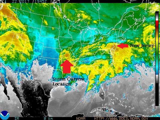
The picture below is a colored IR satellite shot from about an hour ago. I have marked the two large water masses in the atmosphere, the storm and the wet airmass around us. The storm will swing east across Tenn, Kty, Virginia, and NC before heading north up the coast this evening and smacking into the wet airmass here.
Thanks, Max - changed our reservations. You are so incredibly helpful! I even told a friend who lives at the shore but travels a lot and uses Newark Int'l. about your threads. You're famous!
Thanks Max! I always appreciate and enjoy reading your forecasts. You've become my go-to guy when bad weather hits!
Flood Watch
FLOOD WATCH
NATIONAL WEATHER SERVICE NEW YORK NY
349 PM EST SUN JAN 22 2017
...HEAVY RAIN MONDAY AFTERNOON AND MONDAY NIGHT...
CTZ009-NJZ004-006-103>108-NYZ069>075-176>179-231000-
/O.NEW.KOKX.FA.A.0001.170123T1800Z-170124T1100Z/
/00000.0.ER.000000T0000Z.000000T0000Z.000000T0000Z.OO/
SOUTHERN FAIRFIELD-EASTERN PASSAIC-HUDSON-WESTERN BERGEN-
EASTERN BERGEN-WESTERN ESSEX-EASTERN ESSEX-WESTERN UNION-
EASTERN UNION-ROCKLAND-NORTHERN WESTCHESTER-SOUTHERN WESTCHESTER-
NEW YORK (MANHATTAN)-BRONX-RICHMOND (STATEN ISLAND)-
KINGS (BROOKLYN)-NORTHERN QUEENS-NORTHERN NASSAU-SOUTHERN QUEENS-
SOUTHERN NASSAU-
349 PM EST SUN JAN 22 2017
...FLOOD WATCH IN EFFECT FROM MONDAY AFTERNOON THROUGH LATE
MONDAY NIGHT...
THE NATIONAL WEATHER SERVICE IN UPTON HAS ISSUED A
* FLOOD WATCH FOR PORTIONS OF SOUTHERN CONNECTICUT...NORTHEAST
NEW JERSEY AND SOUTHEAST NEW YORK...INCLUDING THE FOLLOWING
AREAS...IN SOUTHERN CONNECTICUT...SOUTHERN FAIRFIELD. IN
NORTHEAST NEW JERSEY...EASTERN BERGEN...EASTERN ESSEX...
EASTERN PASSAIC...EASTERN UNION...HUDSON...WESTERN BERGEN...
WESTERN ESSEX AND WESTERN UNION. IN SOUTHEAST NEW YORK...
BRONX...KINGS (BROOKLYN)...NEW YORK (MANHATTAN)...NORTHERN
NASSAU...NORTHERN QUEENS...NORTHERN WESTCHESTER...RICHMOND
(STATEN ISLAND)...ROCKLAND...SOUTHERN NASSAU...SOUTHERN QUEENS
AND SOUTHERN WESTCHESTER.
* FROM MONDAY AFTERNOON THROUGH LATE MONDAY NIGHT
* LOW PRESSURE WILL DEVELOP AND STRENGTHEN OFF THE MID-ATLANTIC
COAST ON MONDAY...AND THEN SLOWLY TRACK JUST SOUTH AND EAST OF
THE REGION MONDAY NIGHT INTO TUESDAY. MODERATE TO HEAVY RAIN
WILL DEVELOP ACROSS THE REGION MONDAY AFTERNOON AND CONTINUE
INTO MONDAY NIGHT. RAINFALL AMOUNTS OF 1 TO 3 INCHES, WITH
LOCALLY HIGHER AMOUNTS APPROACHING 4 INCHES ARE EXPECTED. THE
HIGHEST AMOUNTS ARE EXPECTED CLOSER TO THE COAST.
* IMPACTS: IF THE HIGH END RAINFALL AMOUNTS ARE REALIZED, THIS
WILL RESULT IN MODERATE URBAN FLOODING AND MINOR SMALL STREAM
FLOODING IN NORTHEASTERN NJ AND THE LOWER HUDSON VALLEY.
ADDITIONALLY...THE COINCIDENCE OF HIGH TIDE WITH THE HEAVY RAIN
MONDAY EVENING WILL EXACERBATE FLOODING ALONG THE COASTAL
WATERFRONT AND SHORELINE ROADS. THIS INCLUDES ALONG TIDALLY
AFFECTED RIVERS...SUCH AS THE PASSAIC...HACKENSACK...AND HUDSON
RIVER.
PRECAUTIONARY/PREPAREDNESS ACTIONS...
A FLOOD WATCH MEANS THERE IS A POTENTIAL FOR FLOODING BASED ON
CURRENT FORECASTS. YOU SHOULD MONITOR LATER FORECASTS AND BE
ALERT FOR POSSIBLE FLOOD WARNINGS. THOSE LIVING IN AREAS PRONE TO
FLOODING SHOULD BE PREPARED TO TAKE ACTION SHOULD FLOODING
DEVELOP.

Will all tomorrow's recycles be floating down the street before complete pick up?
Although the general outline of the forecast has not changed, models have shown a slower development now for several runs, so some adjustments are in order.
1) Forecast wind timing and speed remain unchanged. See previous posts for wind details.
2) Rain will still develop overnight, but heavier rains now expected to arrive Monday afternoon, and persist into Monday night. Slower progress means heavier rains will be around longer, so revising total rainfall to the higher end of the range: 2 - 3".
3) Sleet enters our forecast. The later arrival of the rain will allow more mixing down of colder upper level air. Although surface temps will remain above freezing, colder air at levels between the cloud deck and the rain could cause prolonged periods of sleet.
The winter weather component has been north west of us all along, and has been creeping closer with each run now for the last 24 hours. Sleet is not freezing rain, and at this time ice accumulation is still not likely, but slick areas could develop, and it could be a very unpleasant evening commute.
NWS has issued a Wind Advisory and a Flood Watch for our area. More significant Watches and Warnings will be in effect north and west, and especially in coastal areas. Check local forecasts before making travel plans.
cramer said:
Thanks, Max - changed our reservations. You are so incredibly helpful! I even told a friend who lives at the shore but travels a lot and uses Newark Int'l. about your threads. You're famous!
Apparently United just grounded all flights within the US due to some IT failure. Lucky you got your change in when you did. Storm or no storm, tomorrow is going to be a horrible day to be flying.

How risky will it be driving back to Maplewood from Bergen County after rush hour Monday night? Is there any risk of a travel emergency shutting down the roads? Will this just be a lot of rain, or reach close to a hurricane type of cancel everything and stay at home situation?
Wind Advisory remains in effect.
Flood Watch remains in effect.
As of this morning, the storm continues its slow walk up the coast.
Some slight adjustments to the forecast bring the rain in later, as you have probably noticed. Heavy rains this afternoon and tonight now trending towards 1 - 2" here with possible areas of 3 - 4". Rain continues into Tuesday morning.
Sleet is now much less likely in the MAPSO area, but north and west may still see significant winter weather and caution should be taken if traveling today.
The main story for this storm remains the wind, currently 15 - 20 steady with 30 mph gusts here, higher at the airport and closer to the shore.
Winds this afternoon are forecast to be 25 - 30 mph today and tonight with gusts to 50. Areas nearer the coast, as well as north and especially east, could experience gusts to 60+ mph.


Jasmo said:
How risky will it be driving back to Maplewood from Bergen County after rush hour Monday night? Is there any risk of a travel emergency shutting down the roads? Will this just be a lot of rain, or reach close to a hurricane type of cancel everything and stay at home situation?
Biggest risk will be accidents. Other than that, roads will not be closed. Parkway has pretty good drainage. Not excellent as there is some puddling on left passing lanes.

Sponsored Business


Promote your business here - Businesses get highlighted throughout the site and you can add a deal.
For Sale


Advertisement


Watching a developing system that is likely to drop a lot of rain on us -- on the entire Northeast, in fact -- along with some brisk winds.
The energy that will comprise this multi-headed system is still offshore in the Pacific at this time, not landing until late today or tomorrow, then moving quickly across the southern half of the country before turning up the coast and slowing. Details to timing are still changing from model to model, but it looks like it could go 24 hours and drop 2 - 3" of rain.
There is little to no chance of snow with this system. Moderate winds likely, in the 20+ mph range per current guidence.
Current models put the timing from late Sunday night through Tuesday morning inclusive (that is, this is not a range but a duration). Look for flash flood advisories if the forecast holds up.
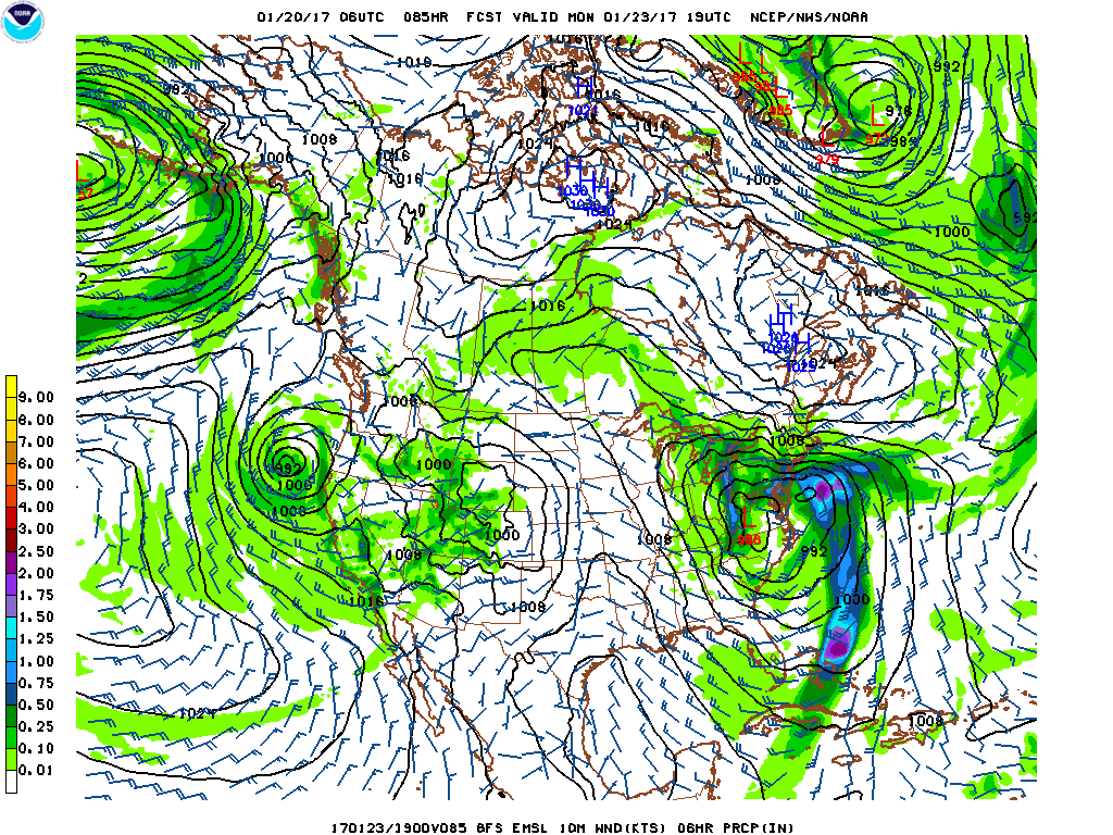
Below is this morning's GFS run, hour 85, which is Monday midafternoon, showing the heavy rain, the (at that point) two central low pressures, winds of 15 - 20 knots, and even heavier rain and winds just off the coast.