Hurricane Harvey -- not a hyperlocal weather post

Max, can I persuade you that it would be more convenient for older people like me that it would be helpful to add the date to the subject line because we get confused easily? A headline applying to "today" does not apply after today, but the headline persists.
Thank you
The NYT Sunday Review Oct 7, 2016 - "When the Next Hurricane Hits Texas."
https://www.nytimes.com/2016/10/09/opinion/sunday/when-the-hurricane-hits-texas.html

mrmaplewood said:
Max, can I persuade you that it would be more convenient for older people like me that it would be helpful to add the date to the subject line because we get confused easily? A headline applying to "today" does not apply after today, but the headline persists.
Thank you
Good point, and when I am talking about events here, I try to remember to do that. I also update the headlines with current information when writing about weather warnings and such. If have have slacked off recently, well, thanks for the heads-up and I will be more careful.
This is going to be a five day event, at least, though, so I think I will let this one ride.


From Tropical depression to major hurricane in two days. Amazing but not surprising. All those additional tera-joules of energy in the water.
But lets keep on making believe global warming is simply a Chinese plot. And if something should happen to come our way, we'll ask our fine evangelicals friends to pray it away.

Thank you Max. Please post all info you can. My daughter is in Houston, and of course, I'm worried.


A large chunk of the U.S.'s refining capacity is along the gulf coast. If some or all of that shuts down you will see gas prices jump. Gas futures are already up.
This will likely be the third massive flood event to hit Houston in as many years. Both the 2015 and 2016 floods were caused by roughly 15-20 inches of rain over 2 days, and NOAA's precip predictions for the area are between 15-25 inches over the same time frame.
NOAA's Harvey briefing page: http://www.weather.gov/akq/Harvey
NHC's predicted precip: http://www.nhc.noaa.gov/refresh/graphics_at4+shtml/212153.shtml?rainqpf#content
There is uncertainty with where Harvey will stall and how the two high pressure systems will steer it until it dissipates. If Houston is lucky, the heavy precip will stall further south, but it is anyone's guess at this point.


I'm a Houston native and still have many friends and family members there and in central Texas who are in it's path. Thanks for the info!


Thread drift - just drove thru VA and saw a historical marker about Hurricane Camille laying waste to Nelson County. Had to look it up. 40" of rain (unofficial since the gauges didn't hold that much) in one night. Fascinating and terrifying on so many levels.
Max, I live in San Antonio but am in NC until Monday. Very happy to have your commentary.
Can't have a weather thread without requests for travel advice. Do you think my Monday evening flight from RDU to SAT will be delayed?
Just kidding. Too soon to tell. Besides, the house might be gone. We live by a river.


NASA Video from the International Space Station of Hurricane Harvey. Terrifying. I pray for the safety of those in its path.
Published on Aug 24, 2017
The National Hurricane Center (NHC) upgraded the remnants of tropical storm Harvey to a tropical depression on August 23, 2017 at 11 a.m. EDT (1500 UTC). Harvey became better organized and was revived after moving from Mexico's Yucatan Peninsula into the Bay of Campeche. The warm waters of the Gulf of Mexico and favorable vertical wind shear promoted the regeneration of the tropical cyclone. This video includes views from The International Space Station recorded on August 24, 2017 at 6:15 p.m. Eastern Time. This video is available for download from NASA's Image and Video Library: https://images.nasa.gov/#/details-NHQ...

what are the chances of states beyond Texas and Louisiana (?) being affected? I'm thinking:
A) this 'storm' is sooooooooo powerful - we know how that feels....
B) systems that big are also a little unpredictable as they unleash, and I have a hazy mental map of the States with their names. (Running now to consult online map)
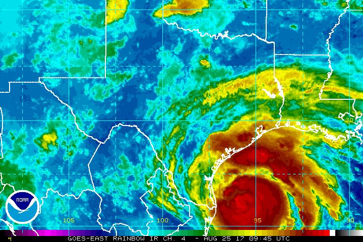
Hurricane track has shifted south the last few model runs, with a good consensus for landfall late tonight or early Saturday as a cat 3 hurricane (winds over 110mph) between Corpus Christi and Victoria, Texas. Then moves slowly along the coast towards Houston and Galveston through Wednesday, gradually losing strength.
Rain of 15 - 35" over this time period will cause extensive and dangerous flooding. Rains of up to 7" will extend well inland into the Texas Hill Country and Mississippi Valley. Storm surge could exceed 10' above mean high tide in areas near landfall.
If Harvey stays on this track, Houston will experience some flooding and several very high tides, but will avoid the massive damage that would come from a direct hit. The strength of the consensus in the models is somewhat reassuring this morning (if you live in Houston, this will be a near miss, not a direct hit), and Texas seems to be taking this seriously and taking appropriate precautions.
kthnry said:
Can't have a weather thread without requests for travel advice. Do you think my Monday evening flight from RDU to SAT will be delayed?
Just kidding. Too soon to tell. Besides, the house might be gone. We live by a river.
I'd get the dogs out of the river tonight.
DottyParker said:
NASA Video from the International Space Station of Hurricane Harvey. Terrifying. I pray for the safety of those in its path.
Very cool. I had not seen that.
joanne said:
what are the chances of states beyond Texas and Louisiana (?) being affected? I'm thinking:
A) this 'storm' is sooooooooo powerful - we know how that feels....
B) systems that big are also a little unpredictable as they unleash, and I have a hazy mental map of the States with their names. (Running now to consult online map)
This is a very slow moving system. By the time it gets past Houston, we are out of the most accurate range of the forecast models. That said, right now they expect the system, as a post-tropical depression, to run up the Mississippi Valley through Louisiana and Arkansas.
thank you for your lovely, clear details! And so early in the day.
Our last, scary cyclone was a truly slow mover (seemingly staying put for a day or three, then doubling back a bit as she weakened, then slowly drifting down the coast); loads of damage from which we're still cleaning up. We're glad to read communities are taking such good precautions.
(I'm also glad to read D's relatives in Florida aren't so likely to be affected this time)
Harvey has powered up to a Cat 4.
Catastrophic damage will occur: Well-built framed homes can sustain severe damage with loss of most of the roof structure and/or some exterior walls. Most trees will be snapped or uprooted and power poles downed. Fallen trees and power poles will isolate residential areas. Power outages will last weeks to possibly months. Most of the area will be uninhabitable for weeks or months.
It will feel as if a nuke went off nearby, absent the radiation. Horrible.
My friends and family in the hill country around Austin and San Antonio are bracing for a LOT of rain, as I believe there is an expectation that the system will stall. But the winds probably won't be so bad in those areas, which are well over 100 miles inland.
I'd worry about the rain.
Many times I've seen TV stories of flooding with 2 - 3" of rain; people being pulled from cars, etc.
Now we are told some places they'll be seeing 10x as much.
If the ground can't absorb the water will flow. If you have a 3,000 sq ft house and there is 10 inches of rain then the house will be hit with 18,700 gallons of water. A 156,000 lbs of water flowing onto your property. And this doesn't include the water which falls directly on your land.
If you're lucky, you're not a the low neighborhood elevation and the water will flow off. If you're in a low elevation, the water will accumulate, including all the water from other higher elevation properties. You could be at one end of the street which is 3 feet lower. Or your property may just provide the flow channel from the higher to the lower elevations. You will have a front door river.
BG9, wouldn't local government have appropriate advice in easy-to-access Disaster Preparedness pages on their sites and take-home booklets? Especially after Wilma and Katrina etc? Ours do, and they're constantly updated.
So people already know they're living in flood plains, surge areas, etc; they've tied up loose items, raised items off floors to the highest possible levels, checked insurance for flood/stormwater damage conditions and are hoping it'll go as quietly as possible.
Three days of your house shaking, roof shaking, water and wind attempting to get through any opening around your walls or under your doors/floors isn't comforting, but for some of us it's just the prospect of late summer's Wet Season (especially the last decade or so, when they've been saying 'it's once-in-a-century')... What matters isn't so much your house and property. It's how quickly the rest of the city's infrastructure comes back to normal.
This is the kind of content/advice/response I mean:
http://www.goldcoast.qld.gov.au/council/disaster-management-120.html
joanne said:
BG9, wouldn't local government have appropriate advice in easy-to-access Disaster Preparedness pages on their sites and take-home booklets? Especially after Wilma and Katrina etc? Ours do, and they're constantly updated.
The only site I know about is the national hurricane what-to-do sites.
http://www.nws.noaa.gov/om/hurricane/index.shtml
http://www.nws.noaa.gov/om/hurricane/plan.shtml
Locally there isn't much advice. Its either not so bad, stock up on supplies, shutter your house and stay put or stock up with supplies needed for your evacuation.
oh. From a community development perspective, that seems really odd! Even our Red Cross has the Ready Plan page...
http://www.redcross.org.au/prepare.aspx
nypost.com: Houston Man goes hand-fishing in his home flooded by Hurricane Harvey
http://nypost.com/2017/08/27/man-goes-fishing-in-flooded-house-after-hurricane-harvey/

Relatives in Austin close enough to the center of things to take a drenching. Seen pictures of the flooding there. Sad to say Houston is devastated. Wish I had something thing optimistic to say. Time for prayers,
there is still power in the old ways.
Author, the true effect won't be felt for a few days - the upstream effect has to flow down and amplify local flooding. People always forget about that , and think it's 'over' or 'safe'...

Sponsored Business


Promote your business here - Businesses get highlighted throughout the site and you can add a deal.
Featured Events
-
Stephen Whitty Presents - Hometown Movie Stars: The Celebrated Actors Of CHS
May 6, 2024 at 7:00pm


Advertisement


Hurricane Harvey: Let's talk.
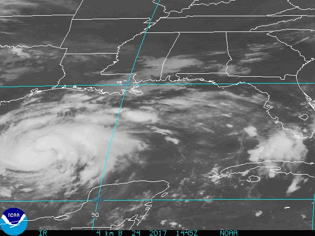
First, this weather system will not effect MAPSO. In fact, at this time, there are no tropical systems on the map that I foresee affecting our area.
But Harvey is going to cream Texas.
20+ inches of rain from Corpus Christi to St. Charles, La; inland as far as San Antonio and Austin. 110mph+ winds at landfall, with a possible direct hit on Houston and Galveston. Tropical force winds and rain for as much as FIVE CONSECUTIVE DAYS.
At this time Harvey is forecast to make landfall on the Texas Gulf Coast during the day Friday as a Major Hurricane. A major hurricane is defined as one where the wind speeds are greater than 110mph. Harvey is then forecast to stall just inland for several days, remaining at hurricane strength for 24 hours and then as a tropical storm, pumping water from the Gulf onto south Texas.
This is a major catastrophic forecast, with hundreds of millions of dollars in potential damages and hundreds of thousands displace from their homes.
I normally limit these posts to hyperlocal weather, but this portends to be a weather event with national repercussions that I think is being underreported this morning, so I wanted to raise your awareness.