Flood Watch Ended, some rain possible Sunday.


So, saying I have no reason to celebrate Father's Day, it would be a fine time to hunker down?


Great - all day lacrosse tournament (in Boonton)...and my father flying in that night...le sigh
Thanks for the heads up though


Naturally, because we're celebrating Father's Day at Yankee Stadium

So not a good day to go to the track? It would stink to drive all the way there to have the races be canceled. (If they do that, I have no idea.

Kids organized a great Fathers Day outing to Coney Island. Grrrrr!! On to Plan B

One of my former neighbors in the old country put together this tool for measuring the gallons of water which fell in a given space...i.e., your yard.
http://water.usgs.gov/edu/activity-howmuchrain.html
Of course it is going to rain buckets on my day off from my summer job! :-(
Is there any chance this becomes less of an issue as we get closer to Sunday? We're supposed to have a backyard birthday party for my turning-7 year old, and I would really love to keep the 30 kids outside!!

Heaviest rain will probably be in the morning and early afternoon. There is a slight chance this doesn't happen, but it is a very slight chance.


Max, our ROCK To Defeat ALS fundraiser is tonight at the Elk's Lodge (all very welcomed). It looks like a pretty gloomy forecast. What are the chances that it holds off til after midnight?
Thanks so much for all you do! Rock on! ;-)
Light showers now, and likely increasing during the afternoon. Possibility of a thundershower.
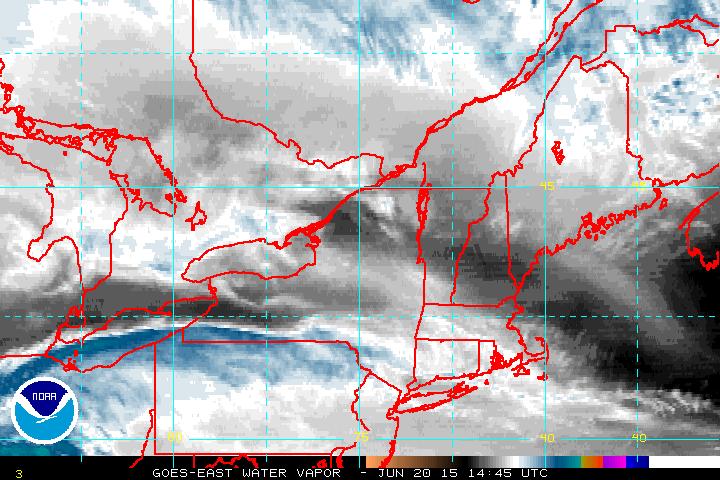
As the moisture from the remnants of TS Bill are pulled east ahead of the front, rain will increase (See first image below. You can see the moisture from Bill, which is west of Pittsburgh now, riding the warm front along the NY/PA border).
Rain increases overnight, with the possibility of a thunderstorm during the early morning hours. There is a FLOOD WATCH (posted below) in effect for our area from 8:00 tonight until 8:00 Monday.
Although Bill per se moves out by midafternoon Sunday, there is a second system behind it that will bring more rain late Sunday afternoon and evening. This will be a lighter rain.
FLOOD WATCH NATIONAL WEATHER SERVICE NEW YORK NY 322 AM EDT SAT JUN 20 2015
...HEAVY RAIN POSSIBLE FROM THE REMNANTS OF BILL TONIGHT THROUGH SUNDAY AFTERNOON
... NJZ002-004-006-103>108-NYZ069>075-176>179-202115-
WESTERN PASSAIC-EASTERN PASSAIC-HUDSON-WESTERN BERGEN- EASTERN BERGEN-
WESTERN ESSEX-EASTERN ESSEX-WESTERN UNION- EASTERN UNION-ROCKLAND-
NORTHERN WESTCHESTER-SOUTHERN WESTCHESTER- NEW YORK (MANHATTAN)-
BRONX-RICHMOND (STATEN ISLAND)- KINGS (BROOKLYN)-NORTHERN QUEENS-
NORTHERN NASSAU-SOUTHERN QUEENS- SOUTHERN NASSAU-

322 AM EDT SAT JUN 20 2015

...FLOOD WATCH REMAINS IN EFFECT FROM THIS EVENING
THROUGH SUNDAY EVENING...
THE FLOOD WATCH CONTINUES FOR
* PORTIONS OF NORTHEAST NEW JERSEY AND SOUTHEAST NEW YORK

 * FROM THIS EVENING THROUGH SUNDAY EVENING
* HEAVY RAINFALL FROM THE REMNANTS OF BILL IS EXPECTED TO IMPACT THE AREA TONIGHT
THROUGH SUNDAY EVENING. THE HEAVIEST RAIN IS EXPECTED TO OCCUR DURING THE
OVERNIGHT HOURS TONIGHT INTO SUNDAY MORNING...AND COULD LEAD TO WIDESPREAD
URBAN AND SMALL STREAM FLOODING. STORM TOTAL RAINFALL AMOUNTS ARE EXPECTED
TO RANGE BETWEEN 1 TO 2 INCHES...ALTHOUGH AMOUNTS OF UP TO 3 INCHES WILL BE
POSSIBLE WITH AREAS OF HEAVIER RAIN...AND IN THUNDERSTORMS. THE HEAVY RAINFALL
SATURDAY NIGHT COULD FALL WITHIN A SHORT PERIOD OF TIME...LEADING TO SHARP RISES
ON SMALL STREAMS AND CREEKS IN NORTHEAST NEW JERSEY AND SIGNIFICANT POOR DRAINAGE
FLOODING IN URBAN AREAS. PRECAUTIONARY/PREPAREDNESS ACTIONS

... A FLOOD WATCH MEANS THERE IS A POTENTIAL FOR FLOODING BASED ON CURRENT FORECASTS.
YOU SHOULD MONITOR LATER FORECASTS AND BE ALERT FOR POSSIBLE FLOOD WARNINGS.
THOSE LIVING IN AREAS PRONE TO FLOODING SHOULD BE PREPARED TO TAKE ACTION SHOULD
FLOODING DEVELOP.
I just want to emphasize that we are not getting a tropical storm per se, and that the only wind with this event is the gusts you would normally expect if there is a thunderstorm. The rain will be spread over several hours, with luck. Just watch the creeks and the low places that are prone to flooding.
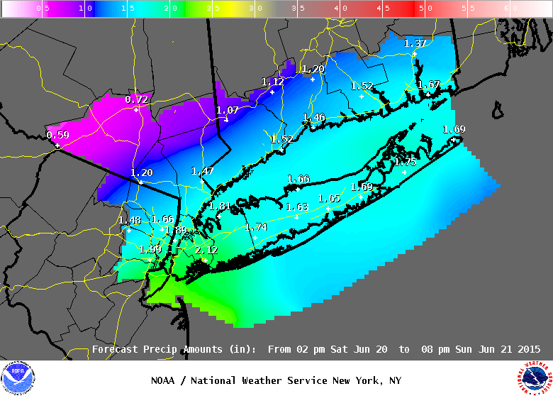
Slight adjustment in the afternoon precipitation map, but the net result for the immediat MAPSO area is the same, 1.5 - 2.0" over 24 hours.
The leading edge of the precipitation looks to be at least a couple of hours away still. I think the heaviest precipitation will come between 3:00am and early afternoon tomorrow, a general inch or so, with up to an inch more in thunderstorms. The NWS, who are smarter than I am, think the general rainfall will be slightly higher. The heaviest rain is currently west of Philly but east of Gettysburg, with some embedded thunderstorms. The leading edge of showers is expanding east as the main line of rain moves east as well. There is a smaller, less intense system behind the main one which will come through tomorrow evening. Most of the models have us right in the bulls-eye for heaviest rainfall. Winds remain modest except, as expected, for gusting within storms.
The NWS has Severe Thunderstorm Watches posted over the whole Philly area and up north as far as Princeton now, with warnings over NE Maryland and Delaware. Expect ours will come just after midnight.

Just took a quick look at the forecast and it looks like it changed for the better. Only a 20 percent chance of rain to day with clearing in the afternoon. No watches or warnings anymore.
Is this correct, Max?
Yes, things moved through more quickly than anticipated, although this morning the chance of showers is 60% (NWS) although I don't see much on the radar. By mid-morning chance drops below 50%, but as it get hot & humid today cannot rule out late-day showers or a storm. Flood watch has been lifted.


Sponsored Business


Promote your business here - Businesses get highlighted throughout the site and you can add a deal.
Rentals


Advertisement


The models are converging on a path just to our south for the remnants of tropical storm Bill, which are currently dousing the area around Branson, Missouri. At the high end, we could see 2.25" of rain, although a more likely track puts us in the 1.25 - 1.75" zone. This could cause small stream and road flooding.
Most likely, this would be an all-day rain.